- Buchanan Field Airport
-
For the other uses, see Concord Airport (disambiguation).
Buchanan Field Airport 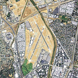
USGS Orthophoto, 2006 IATA: CCR – ICAO: KCCR Summary Airport type Public Operator Contra Costa County Location Contra Costa County, near Concord, California Elevation AMSL 26 ft / 7.9 m Coordinates 37°59′23″N 122°03′25″W / 37.98972°N 122.05694°WCoordinates: 37°59′23″N 122°03′25″W / 37.98972°N 122.05694°W Runways Direction Length Surface ft m 1L/19R 5,001 1,524 Asphalt/Concrete 1R/19L 2,770 844 Asphalt 14L/32R 4,602 1,403 Asphalt/Concrete 14R/32L 2,799 853 Asphalt 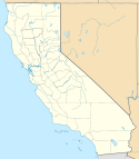
 Buchanan Field AirportLocation of Buchanan Field Airport, California
Buchanan Field Airport (IATA: CCR, ICAO: KCCR) is located in Concord and Pacheco, California, USA, 27 nautical miles (50 km) northeast of San Francisco International Airport, in Contra Costa County.[1] The airport has a control tower and a high volume of general aviation traffic, with over 500 aircraft based on the field (mostly single-engine).
Contents
History
In 1942 Contra Costa County, California purchased land to build an airport in Central County for $88,000. The airport was being developed by the County when World War II broke-out and the United States Army Air Forces Fourth Air Force expropriated the site. The Army added additional land and built the airport facilities. They also built a training base for pilots and the base was known as Concord Army Airfeld.[2]
In 1946 the War Assets Administration (WAA) returned the airport to the County for public use. In August 1946 the airport was renamed after County Supervisor William J. Buchanan, who served was a board member for more than forty years. The airport continued to be used on occasion by the U.S. Army to transport troops, especially during the Korean War.[2]
In 1977 Buchanan Field reached its peak of activity with 357,000 total operations; by that criterion Buchanan Field was the 16th busiest airport in the nation, ahead of San Francisco International Airport, John F. Kennedy International Airport, and LaGuardia Airport. During this time noise became a concern and in 1988 the county Board of Supervisors instituted a county noise restriction ordinance restricting certain aircraft from operating at Buchanan Field.[2]
Beginning in the 1990s, the Board of Supervisors updated the Buchanan Field Airport Master Plan. Commercial development of adjacent property such as Sams Club, Taco Bell, Sports Authority, and Jiffy Lube was allowed in 1992.[2] The future direction of this airport is always in question because of its location on prime property in the middle of the city of Concord with no room to grow, and noise concerns. The County has developed a new airport in Byron in the eastern part of the county.[2]
Accidents
On the evening of December 23, 1985, a Beechcraft Baron N1494G, executing a missed instrument approach procedure from an approach to runway 19R, lost control and crashed into the roof of the Macy's Department Store at nearby Sunvalley Mall, killing the pilot and two passengers and seriously injuring 84 Christmas shoppers in the crowded mall below, mainly by spraying them with burning fuel. Four of the victims on the ground later died from their injuries. The accident brought increased local opposition to the airport, and caused Pacific Southwest Airlines to delay scheduled passenger service that had been planned to start in January 1986.
Another plane crashed on April 13, 2004, shortly after leaving Buchanan Field. The plane landed on a minivan traveling down nearby Interstate 680 in Pleasant Hill and nearly severed the left leg of a 12-year-old girl (Her leg was successfully reattached and she has made a near full recovery). Officials determined the crash was the fault of a mechanic who had worked on the plane.[3]
On December 21, 2006, at approximately 1900 Zulu, a Piper Malibu (PA46) crashed while flying the LDA (Localizer Directional Aid) approach into CCR. The aircraft was flying too low to terrain and impacted obstructions on the ground. The plane hit the median of Highway 4, crashing between the highway and Marsh Drive just directly north of the runway. Three passengers were killed instantly one died after surgery.[4]
Airlines and destinations
Buchanan Field does not currently have scheduled commercial air service.
Commuter airline flights to San Francisco (Beech 99s, Islanders) started in 1969, but were gone by 1980. Pacific Southwest Airlines (PSA) offered service from Buchanan Field to Los Angeles International Airport, beginning May 1, 1986. PSA offered four to five daily roundtrips on the route with 100-seat BAe 146 aircraft. USAir continued the service after purchasing PSA in 1987, but replaced the 146s with Dash 8s in 1991. That year USAir announced that it was dismantling most of the West Coast network that it had acquired from PSA, including Concord, where flights ended in 1992. Buchanan Field has had no airline flights since.
See also
References
 This article incorporates public domain material from websites or documents of the Air Force Historical Research Agency.
- ^ "Buchanan Field". Geographic Names Information System, U.S. Geological Survey. http://geonames.usgs.gov/pls/gnispublic/f?p=gnispq:3:::NO::P3_FID:1653363. Retrieved 2009-05-04.
- ^ a b c d e The History of Contra Costa County Airports, Contra Costa County Airports. Retrieved 2007-08-14.
- ^ http://www.sfgate.com/cgi-bin/article.cgi?f=/c/a/2004/04/14/MNGGV64RA21.DTL
- ^ http://findarticles.com/p/articles/mi_qn4176/is_20061222/ai_n17075973
External links
- Buchanan Field Airport (official web site)
- The Airport Coalition
- Sunvalley Mall Crash
- Airport Master Record (FAA Form 5010), also available as a pdf: printable form
- FAA Airport Diagram (PDF), effective 20 October 2011
- Resources for this airport:
- AirNav airport information for KCCR
- ASN accident history for CCR
- FlightAware airport information and live flight tracker
- NOAA/NWS latest weather observations
- SkyVector aeronautical chart, Terminal Procedures for KCCR
Airports in the San Francisco Bay Area International Federal General aviation (tower) Concord/Buchanan (KCCR) · Hayward (KHWD) · Livermore (KLVK) · Napa (KAPC) · Palo Alto (KPAO) · San Jose/Reid-Hillview (KRHV) · San Carlos (KSQL) · Santa Rosa/Sonoma County (KSTS)General aviation (non-tower) Angwin-Parrett (2O3) · Byron (C83) · Cloverdale (O60) · Marin County/Gnoss (KDVO) · Half Moon Bay (KHAF) · Healdsburg (O31) · Hollister (KCVH) · Vacaville/Nut Tree (KVCB) · Petaluma (O69) · Rio Vista (O88) · Sonoma Skypark (0Q9) · Sonoma Valley (0Q3) · San Martin/South County (E16) · Watsonville (KWVI)Historical Airfields Group Training Stations · Replacement Training Stations · Tactical Airfields
Units Commands IV Bomber Command · IV Fighter Command · IV Air Support CommandWings 21st Bombardment · Los Angeles Fighter · San Diego Fighter · San Francisco Fighter · Seattle FighterGroups Bombardment 12th Bombardment · 30th Bombardment · 41st Bombardment · 42d Bombardment · 47th Bombardment · 380th Bombardment · 385th Bombardment · 389th Bombardment · 392d Bombardment · 399th Bombardment · 449th Bombardment · 450th Bombardment · 451st Bombardment · 453rd Bombardment · 454th Bombardment · 455th Bombardment · 456th Bombardment · 461st Bombardment · 463d Bombardment · 465th Bombardment · 466th Bombardment · 470th Bombardment · 483rd Bombardment · 486th Bombardment · 491st Bombardment · 492d BombardmentFighter 1st Fighter · 14th Fighter · 20th Fighter · 35th Fighter · 51st Fighter · 55th Fighter · 78th Fighter · 81st Fighter · 82d Fighter · 328th Fighter · 329th Fighter · 339th Fighter · 354th Fighter · 360th Fighter · 363rd Fighter · 364th Fighter · 369th Fighter · 367th Fighter · 372d Fighter · 412th Fighter · 473d Fighter · 474th Fighter · 478th Fighter · 479th FighterReconnaissance 68th Reconnaissance · 69th ReconnaissanceTroop Carrier Categories:- Airports in the San Francisco Bay Area
- 1942 establishments
- USAAF Fourth Air Force Replacement Training Stations
- Airfields of the United States Army Air Forces in California
- Concord, California
- Airports in Contra Costa County, California


Wikimedia Foundation. 2010.