- Autoroutes of France
-
 Map (government-owned autoroutes are in black and privately-Owned autoroutes are in blue)
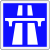
The Autoroute system in France consists largely of toll roads, except around large cities and in parts of the north. It is a network of 12,000 km (7,500 mi) worth of motorways. Autoroute destinations are shown in blue, while destinations reached through a combination of autoroutes are shown with an added autoroute logo. Toll autoroutes are signalled with the word péage (toll).
Contents
 The French Autoroute A1
 A French motorway.
Naming and numbering
Unlike other highway systems, there is no systematic numbering system, but there is a clustering of Autoroute numbers based on region. A1, A3, A4, A5, A6, A10, A13, A14, A15, A16 radiate from Paris with A2, A11, and A12 branching from A1, A10, and A13, respectively. A7 begins in Lyon, where A6 ends. A8 and A9 begin respectively near Aix-en-Provence and Avignon. The 20s are found in northern France. The 30s are found in Eastern France. The 40s are found near the Alps. The 50s are near the French Riviera. The 60s are found in southern France. The 70s are found in the centre of the country. The 80s are found west of Paris.
Some of the autoroutes have their own name in addition to a number: for instance, A6 and A7 are autoroute du Soleil (sun motorway), for they lead from northern to southern France and its sunny beach resorts. The A13 is named the autoroute de Normandie as it traverses Normandy. The A29 is part of the route des Estuaires, a chain of motorways crossing the estuaries of the English Channel. Additionally, the A40 is named the autoroute blanche (white motorway) because it is the road that goes to Chamonix and other French winter resort towns, and the N104, one of Paris's beltways, is also known as La Francilienne because it circles the region of Ile-de-France.
Administration
The status of motorways in France has been subject of debate through years, from their construction until recently. Originally, the Autoroutes were built by private companies mandated by the French government, and followed strict construction rules as described below. They are operated and maintained by mixed companies held in part by private interests and in part by the state. Those companies hold concessions, which means that Autoroutes belong to the French state and their administration to semi-private companies. The different companies are as follows:
- ALIS (SEM, SAPN 8%, Bouygues 20.2%, Ixis 26%, DTP Terrassement 13.44%), concessionnaire de l'A28 Rouen-Alençon 125 km, Alis, official site
- SAPRR (Autoroutes Paris-Rhin-Rhône), 1801 km, SAPRR, official site
- AREA (Société des Autoroutes Rhône-Alpes, SAPRR Subsidiary at 99.82%), 381 km, AREA, official site
- ASF (Autoroutes du sud de la France), 2325 km, ASF, official site
- ATMB Autoroutes et tunnels du Mont-Blanc, 107 km, ATMB, official site
- CEVM (Viaduc de Millau, groupe Eiffage), 2.5 km, CEVM, official site
- Cofiroute (Compagnie Industrielle et Financière des Autoroutes, private company part of Vinci group), 896 km, Cofiroute, official site
- Escota (Société des Autoroutes Esterel-Côte d'Azur, ASF group), 460 km, Escota, official site
- Sanef (Société des autoroutes du Nord et de l'Est de la France), A.C.S. group (Spain), 1317 km, SANEF, official site
- SAPN (Société des autoroutes Paris-Normandie, SEM, groupe Sanef), 366 km, SAPN, official site
- SFTRF, Société française du tunnel routier du Fréjus, 67 km, SFRTF, official site
Only in the Brittany region do most of the autoroutes belong to the government. They are operated by the regional council and are free from tolls.
Safety on French autoroutes
France has the following speed limits for limited access roads:
- Under normal conditions - 130 km/h (80 mph)
- In rain or wet road conditions - 110 km/h (70 mph)
- In heavy fog or snowy/icy conditions - 50 km/h (30 mph)
In normal conditions, there is a minimum speed of 80 km/h (50 mph) in the lane most left (no minimum speed on the others' right lanes, but speed should be adapted for each situation : not too slow).
The autoroutes are designed to increase the safety of drivers; this allows a higher speed limit (130 km/h or 80 mph) than on the normal roads (90 km/h or 55 mph) with an acceptable risk of accident.
 Dynamic information panel used on the French Autoroute.
The safety measures are:
- one way driving: the lanes driving in the opposite direction are separated by at least a crash barrier which is designed to resist the oblique impact of a car at up to 180 km/h (110 mph); no intersecting roads but bridges and tunnels;
- larger lanes, at least 2 (often 3) lanes driving in the same direction, with a larger turning radius - some recently built autoroutes have one-lane-only sections;
- long acceleration and slowing lanes to get in or out of the autoroute without disturbing the traffic;
- presence of an additional emergency lane where it is forbidden to drive (except for the emergency services) and to park (except in case of emergency);
- presence of emergency call boxes every 2 km (1.2 mi) on each side, that allow to call for help with the possibility to locate the call; some call boxes have flashing light that warn when there is a problem ahead;
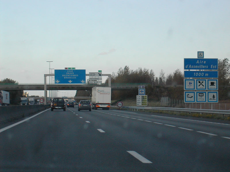
- presence every 10 km (6.2 mi) (4–6 minutes of driving) of resting zones (aire de repos, i.e. car parks with public toilets), and every 40 km (25 mi) (20–30 minutes of driving) of a resting zone with a restaurant and a gas station - on most recently built autoroutes these distances are longer;
- regular patrols of the security services, to clear any obstacle and protect drivers in trouble (usually a breakdown or a flat tyre) with appropriate warning signs and beacons;
- dynamic information panels which warn about possible difficulties ahead (accident, men at work, traffic jam);
- an FM radio station (107.7 MHz) dedicated to information about traffic conditions on most of the network;
- on heavy traffic days (e.g. beginning and end of school holidays): organisation of specific information and recreation events at rest areas;
- radars automatiques (speed cameras) currently being installed in many locations.
Economics
The toll roads were granted as concessions to mixed-economy corporations; the freeways roads are directly administered by the national government. Tolls are either based on a flat-rate for access to the road or on the distance driven. The latter case is the most common for long distances; users take a ticket from an automatic machine when they enter the autoroute, and pay according to the distance when exiting; toll booths accept debit cards, credit cards, as well as cash.

In 2005, the Villepin government proposed a controversial plan to sell all of the state's holdings in autoroute companies to private investors. Critics contend that the price announced is well below the profit forecasts for these companies, and thus that the government sacrifices the future to solve current budgetary problems.[1]
List of Autoroutes
A1 - A9
- A1 : Autoroute du Nord Paris Porte de la Chapelle - Lille
- A2 : Combles - Belgium
- A3 : Paris Porte de Bagnolet - Paris-Nord
- A4 : Autoroute de l'Est Paris Porte de Bercy - Strasbourg
- A5 : Vert-Saint-Denis (Seine-et-Marne) - Langres
- A6 E15 : Autoroute du Sud and Autoroute du Soleil : Paris - Lyon
- A7 E15 : Autoroute du Soleil : Lyon - Marseille
- A8 La Provençale : La Fare-les-Oliviers - Italy
- A9 La Languedocienne/La Catalane Orange - Narbonne - Spain
A10 - A20
 A10 autoroute near Paris
- A10 L'Aquitaine : Rungis - Orly - Bordeaux
- A11 L'Océane : Saint-Arnoult-en-Yvelines - Nantes
- A12 : A13 (Rocquencourt) - Trappes
- A13 Autoroute de Normandie : Paris (Porte d'Auteuil) - Caen (Porte de Paris)
- A14 : Orgeval - La Défense
- A15 : Gennevilliers - Cergy (and formerly - Pont de Tancarville - Le Havre)
- A16 L'Européenne : L'Isle-Adam - Beauvais - Amiens - Abbeville - Boulogne-sur-Mer - Calais - Dunkerque - Belgium
- A19 : Orléans (A10 at Artenay) - Sens
- A20 L'Occitane : Vierzon - Montauban
A21 - A29
- A21 Rocade Minière : Lens - Douai - Denain
- A22 : Lesquin - Belgium
- A23 : Lesquin - Valenciennes
- A24 : Amiens - Lille - Belgium (proposed)
- A25 : Lesquin - Dunkerque
- A26 Autoroute des Anglais : Troyes - Calais
- A27 : Lesquin - Lille - Belgium
- A28 Autoroute des Estuaires : Abbeville - Tours
- A29 : A13 - Pont de Normandie - Amiens – Saint-Quentin
A30 - A39
- A 30 : Uckange - Bassompierre
- A 31 : Beaune - Luxembourg
- A 32 : Freyming-Merlebach - Germany
- A 33 : Nancy - Hudiviller (local autoroute around Nancy)
- A 34 : Reims - Charleville-Mézières - Belgium
- A 35 : Lauterbourg - Switzerland (Basel)
- A 36 La Comtoise : (A 31) Ladoix-Serrigny - Germany
- A 38 : Pouilly-en-Auxois - Dijon
- A 39 Autoroute Verte : Dijon - Bourg-en-Bresse
 Motorways A40-A49
A40 - A49
- A40 E62 Autoroute Blanche, Autoroute des Titans : Mâcon - Mont Blanc Tunnel
- A41 : Switzerland (Geneva) - Grenoble
- A42 E611 : Lyon - Bourg-en-Bresse
- A43 : Lyon - Italy
- A44 : (project) bypassing Lyon by west
- A45 : Lyon - Saint-Étienne
- A46 : Anse - Givors (bypassing Lyon by east)
- A47 E70 : Lyon - Saint-Étienne
- A48 : Lyon - Grenoble
- A49 : Grenoble - Valence
 Motorways A50-A59
A50 - A59
- A50 : Marseille - Toulon
- A51 : Marseille - Grenoble
- A52 : Autoroute link between A8 and A50
- A54 : Nîmes - Salon Sud
- A55 : Martigues - Marseille
- A57 : Toulon – Vidauban
 Motorways A60-A69
A60 - A69
- A61 E80 Autoroute des Deux Mers: Toulouse - Narbonne
- A62 E72 Autoroute des Deux Mers: Bordeaux - Toulouse
- A63 E05 Autoroute de la Côte Basque : Bordeaux - Biriatou
- A64 E80 La Pyrénéenne : Toulouse - Bayonne
- A65 E7 : Bordeaux - Pau
- A66 : Toulouse - Pamiers
- A68 : Toulouse – Albi
A70 - A79
- A71 : L'Arverne Orléans - Clermont-Ferrand
- A72 : Saint-Étienne - Clermont-Ferrand
- A75 La Méridienne : Clermont-Ferrand - Pézenas (Béziers in 2009)
- A77 Autoroute de l'Arbre Poligny (A6) - Nevers - Challuy
A80 - A99
 A86 (blue), A104 (green) and the Périphérique (orange).
- A81 : Le Mans - La Gravelle
- A82 : Brest - Nantes (Proposed)
- A83 : Nantes - near Niort
- A84 : Rennes - Caen
- A85 : Angers - Vierzon
- A86 : the second ring road around Paris
- A87 : Mûrs-Erigné - La Roche-sur-Yon
- A88 : Caen - Falaise - Sées
- A89 : Lyon - Arveyres
Others
 A13 in the outskirts of Caen
- A104 : The Francilienne around the Île-de-France (Paris) region
- A105 : Combs-la-Ville
- A110 : Ablis - Tours (proposed)
- A115 : A15 (Sannois) - Méry-sur-Oise
- A131 : Bourneville (A13 exit 26) - Le Havre
- A132 : A13 / Pont-L'Évêque - Canapville
- A154 : A13 - Louviers
- A199 : Torcy - Champs-sur-Marne (downgraded into RD 199)
- A203 : Charleville-Mézières - Glaire
- A260 : Boulogne-sur-Mer - A26
- A320 : A4 - Germany
- A330 : Nancy - Richardménil
- A404 : Saint-Martin-du-Frêne - Oyonnax - Arbent
- A406 : Mâcon
- A430 : Chamousset - Gilly-sur-Isère
- A432 : Saint-Laurent-de-Mure - Montluel
- A508 : Tunnel (access to Monaco)
- A630 : Lormont - Bègles
- A631 : Bègles
- A660 : Mios - Gujan-Mestras
- A680 : Castelmaurou - Verfeil
- A711 : Lempdes - Pont-du-Château
- A719 : Gannat - Monteignet-sur-l'Andelot
- A750 : A75 to Clermont-l'Hérault - Montpellier
- A810 : La Rochelle - A10
- A831 : Rochefort - La Rochelle - Fontenay-le-Comte
- A837 Autoroute des Oiseaux : Rochefort - Écurat (A10)
See also
References
External links
- ASFA Official website ASFA (Federation of French motorway and toll facility companies)
- Motorway numbers in France (route log)
- The automatic tollting system in France: Liber-t
Autoroutes of France 
A 1 | A 2 | A 3 | A 4 | A 5 | A 6 | A 7 | A 8 | A 9 | A 10 | A 11 | A 12 | A 13 | A 14 | A 15 | A 16 | A 19 | A 20 | A 21 | A 22 | A 23 | A 25 | A 26 | A 27 | A 28 | A 29 | A 30 | A 31 | A 32 | A 33 | A 34 | A 35 | A 36 | A 38 | A 39 | A 40 | A 41 | A 42 | A 43 | A 44 | A 45 | A 46 | A 47 | A 48 | A 49 | A 50 | A 51 | A 52 | A 54 | A 55 | A 57 | A 61 | A 62 | A 63 | A 64 | A 65 | A 66 | A 68 | A 71 | A 72 | A 75 | A 77 | A 79 | A 81 | A 83 | A 84 | A 85 | A 86 | A 87 | A 89 | A 103 | A 104 | A 105 | A 110 | A 115 | A 131 | A 132 | A 139 | A 150 | A 151 | A 154 | A 186 | A 199 | A 203 | A 330 | A 390 | A 404 | A 406 | A 430 | A 432 | A 501 | A 520 | A 570 | A 630 | A 660 | A 680 | A 711 | A 719 | A 750 | A 831 | A 837
Categories:- Autoroutes in France


Wikimedia Foundation. 2010.