- Paro Airport
-
Paro Airport 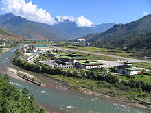
IATA: PBH – ICAO: VQPR Location of airport in Bhutan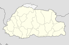
 Paro
Paro
AirportSummary Airport type Public Operator Department of Civil Aviation Location Paro District Elevation AMSL 7,300 ft / 2,230 m Coordinates 27°24′31.75″N 89°25′14.09″E / 27.4088194°N 89.4205806°ECoordinates: 27°24′31.75″N 89°25′14.09″E / 27.4088194°N 89.4205806°E Runways Direction Length Surface ft m 15/33 6,445 1,964 Asphalt Paro Airport (IATA: PBH, ICAO: VQPR) is the only international airport of Bhutan. The airport is located 6 km (3.7 mi) from Paro in a deep valley on the bank of the Paro river at an elevation of 7,300 ft (2,200 m).
With surrounding peaks as high as 18,000 ft (5,500 m) it is considered one of the world's most challenging airports,[1] and as of October 2009, only eight pilots in the world are certified to land at the airport.[2] Flights at Paro are allowed under visual meteorological conditions only and are restricted to daylight hours from sunrise to sunset.[3]
Yongphulla Airport in Trashigang District is the only other airstrip in the country, which is yet undergoing re-construction.[4] The Royal Bhutanese Government's 10th Five Year Plan (which covers 2008-2013) includes the building of at least two further domestic airstrips at Bathpalathang in Bumthang District, and at Gelephu in Sarpang District.[5]
The second international airport project, which was planned for construction at the Gelephu site, was downgraded to a domestic airport project in October 2008.[6] The Bhutanese Department of Civil Aviation indicated in January 2010, that the domestic airport at Gelephu may have provisions to be expanded into an 'all weather' airport, capable of receiving international traffic in the future. Construction is due to start in late 2010, with the airport is due to start operations in June 2011.[7][8]
Contents
Facilities
The airport has a single strip, asphalt runway which is 6,445 feet (1,964 m) in length. There is 1 passenger terminal, 1 cargo terminal and 2 aircraft hangars. There are also 4 check-in desks and 1 gate.
In 2002, the airport handled 37,151 passengers and 90,983 tonnes of cargo.
Airlines and destinations
Druk Air is the national flag carrier airline of Bhutan and has its base at Paro Airport. Buddha Air became the first international airline to operate regularly at Paro.
Airlines Destinations Druk Air Bagdogra, Bangkok-Suvarnabhumi, Delhi, Dhaka, Gaya, Guwahati, Kathmandu, Kolkata Buddha Air Charter: Kathmandu See also
- List of airports in Bhutan
- Yongphulla Airport
References
- ^ Cruz, Magaly; Wilson,James; Nelson, Buzz (July 2003). "737-700 Technical Demonstration Flights in Bhutan". Aero Magazine (3): 1; 2. http://www.boeing.com/commercial/aeromagazine/aero_23/737-700Bhutan.pdf. Retrieved 12 February 2011.
- ^ Farhad Heydari (October 2009). "The World's Scariest Runways". Travel & Leisure. http://www.travelandleisure.com/articles/the-worlds-scariest-runways. Retrieved 12 February 2011.
- ^ "Paro Bhutan". Air Transport Intelligence. Reed Business Information. 2011. http://www.rati.com/APLANDING_14062.htm. Retrieved 12 February 2011.
- ^ Tshering Palden (30 August 2010). "DYT approves quarry without community clearance". Kuensel. http://www.kuenselonline.com/modules.php?name=News&file=article&sid=16565. Retrieved 12 February 2011.
- ^ Tshering Palden (1 September 2009). "Domestic air service to take wing soon". Kuensel. http://www.kuenselonline.com/modules.php?name=News&file=article&sid=13325. Retrieved 12 February 2011.
- ^ Tenzing Lamsang (9 October 2008). "Gelephu Int'l Airport - Now A Domestic One". Kuensel. http://www.kuenselonline.com/modules.php?name=News&file=article&sid=11282. Retrieved 12 February 2011.
- ^ Sonam Pelden (8 January 2010). "Groundwork begins for taking to the air". Kuensel. http://www.kuenselonline.com/modules.php?name=News&file=article&sid=14428. Retrieved 12 February 2011.
- ^ Tashi Dema (25 June 2010). "Land hurdle crossed". Kuensel. http://www.kuenselonline.com/modules.php?name=News&file=article&sid=15876. Retrieved 12 February 2011.
External links
- Druk Air official site
- Airport information for VQPR at World Aero Data. Data current as of October 2006.
Categories:- Airports in Bhutan


Wikimedia Foundation. 2010.