- Church Stretton
-
Coordinates: 52°32′20″N 2°48′25″W / 52.5389°N 2.807°W
Church Stretton 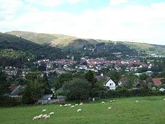
Church Stretton viewed from the Ragleth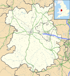
 Church Stretton
Church Stretton shown within ShropshirePopulation 2,789 OS grid reference SO453937 - London 158 miles (254 km) Parish Church Stretton Unitary authority Shropshire Ceremonial county Shropshire Region West Midlands Country England Sovereign state United Kingdom Post town CHURCH STRETTON Postcode district SY6 Dialling code 01694 Police West Mercia Fire Shropshire Ambulance West Midlands EU Parliament West Midlands UK Parliament Ludlow List of places: UK • England • Shropshire  Church Stretton viewed from Nover's Hill; the Hazler and Ragleth hills are behind
 The northern parts of the town from the Burway; the entrance to Carding Mill Valley is below on the left.
Church Stretton is a small town and civil parish in Shropshire, England. The population of the town was recorded as 2,789 in 2001,[1] whilst the population of the wider parish (including the adjacent settlements of All Stretton and Little Stretton) was recorded as 4,186.[2] The town lies entirely in the Shropshire Hills AONB, on the A49 road approximately 13 miles (21 km) south of Shrewsbury, the county town, and 15 miles (24 km) north of Ludlow.
The area has been settled since the Iron Age, during which a hillfort was constructed on Caer Caradoc hill.[3] The town was nicknamed Little Switzerland during the Victorian and Edwardian periods, due to its landscape and development as a health resort.[4] The local geology is complex and incorporates some of the oldest rocks in England - a notable fault is named after the town.[5] Today Church Stretton is a market town as well as being a destination for visitors to the surrounding natural landscape, with the Long Mynd situated on the western side of the town.
Contents
History
People have lived in the Stretton Gap for thousands of years; an Iron Age hillfort on Caer Caradoc[3] overlooks the town. The name "Stretton" is derived from the Old English words stræt meaning "Roman Road" and tun meaning "settlement"; a Roman road, Watling Street runs through the Stretton valley, though the town (and adjacent settlements) were not historically located on this road — during the "Dark Ages" the settlements grew a short distance away from the old thoroughfare, for defensive purposes. Today the modern A49 road, which was constructed on its current alignment through the Stretton Gap in the late 1930s, runs along a similar course to the Roman Road.
The town was granted a market charter by King John in 1214,[6] and the market is still held every Thursday and Saturday, in the square on the High Street. Much of the town centre was destroyed by fire in 1593[6] and many of the present half timbered buildings in the town centre date from the time of the rebuilding.[6]
The High Street was for many centuries known instead as the Bristol Road, being the road from Shrewsbury to Bristol. It was once a much wider street within the town, with the churchyard of St Laurence bordering directly onto the street. Over time buildings were erected on the street, in a similar fashion to other English market towns, such as in Ludlow. The High Street, which is a narrow street, is effectively only the eastern side of the original Bristol Road thoroughfare through the town. It was made more open when the old market hall was demolished to form the present town square.[7]
18th century
During the 18th century, Church Stretton began to develop as a spa town[citation needed]. Historically the town was known for its textiles, specifically in Carding Mill Valley. Carding Mill was built in the 18th century, and named after a stage in making cloth, the three stages being carding, spinning and weaving. Carding would have been done by children, and involved using a hand-card that removed and untangled short fibres from the mass of raw material. The cards were wooden blocks with handles and covered in metal spikes, which were angled, (to make it easier to untangle) and set in leather. When untangled, the material would be spun, and then weaved into the final product.
The carding mill closed at the beginning of the 20th century. The mill is still in the valley today, but has been converted into luxury flats. The valley it was in took the name "Carding Mill Valley", and is now a tourist attraction owned by the National Trust.
Victorian and Edwardian times
Church Stretton was nicknamed "Little Switzerland" during its growth in the late Victorian and Edwardian periods, because of the way many houses hug the hillside, the surrounding mountainous landscape,[4] and because the town is said to have been run like clockwork.[citation needed]
Church Stretton railway station opened on 20 April 1852 as part of the newly created Shrewsbury and Hereford Railway. It was originally situated to the north of (what is now known as) Sandford Avenue and the old station building still remains, but is no longer in railway use. Sandford Avenue had been for centuries called Lake Lane and became Station Road with the arrival of the railway in the town, before becoming Sandford Avenue in 1884.[7]
In 1914 the station was relocated just to the south of the Sandford Avenue road bridge, where it continues to the present day. New station buildings were erected, but these were demolished in 1970, the station having become unstaffed in 1967.[7]
The Long Mynd Hotel on Cunnery Road was built in 1900[citation needed], originally as the Hydro, at a time when the town was popular as a spa. Today it continues as a hotel and has its own swimming pool and woodland trails; it is a wedding and conference venue.[8]
Local property developer Ralph Beaumont Benson (1862–1911), who lived at Lutwyche Hall in nearby Easthope, is responsible for the naming of Easthope Road, Essex Road (after his wife), Beaumont Road and Lutwyche Road, all in the centre of the town and part of the town's expansion in the early 20th century.[9]
Mid-20th century
During the Second World War, from 1940 to 1946, St Dunstan's was based in the town. The charitable service (for blinded armed forces personnel) was relocated from Sussex as Church Stretton was thought to be a safe location. Some 700 people were trained during this period in Church Stretton.[10] The Long Mynd Hotel, the Brockhurst Estate, and Tiger Hall were the most notable buildings taken over by St Dunstan's in the town.[11] A residential cul-de-sac is named St Dunstan's Close in recognition of the charity's place in the town's history. Although Church Stretton avoided the aerial bombing of the war, the Long Mynd was considered to be a potential landing place for German parachutists.[12]
Late 20th century
 The hills and woodland to the west/southwest of the town, as seen from the slope of the Ragleth hill. The Edwardian Long Mynd Hotel is the large, white building amongst the woodland to the left.
A small market hall stood on the High Street but was demolished in July 1963 and the site has become a town square, and is still used to hold markets on. The first market hall — a timber-framed construction — was built in 1617; this was replaced by the second market hall (called the Town Hall) in 1839, which was a stone and red-brick construction.[13] Today the Silvester Horne Institute (extended and refurbished in 2011)[14] is the town's main meeting place for societies, public meetings & exhibitions and polling, and the town council have their offices nearby on the High Street. Additionally there is the Mayfair Community Centre on Easthope Road and the St Laurence's Parish Hall on Church Street.
Geography
 View of The Lawley hill (looking north) from the top of Caer Caradoc.
Church Stretton is located approximately 13 miles (21 km) south of Shropshire's county town, Shrewsbury. The town is dominated by the surrounding hills, including the huge Long Mynd massif to the west, and Caer Caradoc Hill and the adjacent hills (Hazler, Ragleth, et al.) to the east.
Church Stretton effectively lies at a saddle point - the railway station lies roughly at this position, which is at 187m above sea level. The High Street through the town centre runs at an elevation of 194 to 195m. Because of its position at a saddle point, water drains away from the town in two directions - to the north (to the Cound and then the Severn) and to the south (to the Onny and then the Teme) - roughly Sandford Avenue in the town centre forms the watershed. Parts of the town are subject to flooding after heavy rain and in 2000 serious flooding closed the railway line through the town.
Localities
The historic core of the town lies around the church and along the High Street. With the building of the railway line and station in 1852, the town began to grow towards the new station, along what is today Sandford Avenue. Since the first half of the 20th century the two main streets of the town centre are the High Street and Sandford Avenue.
Cunnery is a hillside and collection of houses to the west of the town centre and includes the Long Mynd Hotel. World's End is where the Ludlow Road curves round the foot of the hillside to the south of the Long Mynd Hotel. To the north of the town centre is an area called Ashbrook; here the Carding Mill Valley meets the town, with the stream (known as the Ashbrook as it runs through the town) running between the town's two main recreation fields (named Russell's Meadow and Richard Robinson Field). Two other notable areas of public parkland are Rectory Field & Wood, situated to the west of the town centre off Church Street, and the town's formal park between the A49 and the railway line, which is managed by the town council and includes tennis courts and a bowling green.
On the eastern side of the A49 road are the areas of Battle Field (or Battlefield) and Hazler; on Hazler Hill is a transmitter for local radio (BBC Radio Shropshire broadcast from here on 90FM). Battle Field is named for the legend that Caer Caradoc was the site of the last stand of Caractacus against the Roman legions during the Roman conquest of Britain, and that after the battle he hid in the cave near its summit.
Governance
The town is located within the civil parish of Church Stretton, and is administered by a town council, which also manages the neighbouring villages of All Stretton, Little Stretton, and the hamlets of Minton and Hamperley.[15] At the 2001 census, the parish's population was 4,186.[2] The parish is divided into four wards: Church Stretton North (represented by four councillors on the town council), Church Stretton South (represented by five councillors), All Stretton and Little Stretton (each represented by two councillors).[16]
Sometimes the parish is referred to as "Church Stretton and Little Stretton"; the parish was formed from the merger of the former Little Stretton and Church Stretton parishes, together with part of All Stretton parish (the remainder still exists as a separate parish).[17]
Church Stretton is part of the Shropshire Council electoral division of Church Stretton and Craven Arms.
On a national level, Church Stretton is located within the Ludlow constituency, and the current MP for that constituency is Philip Dunne, a Conservative MP.[18]
Geology
See also: Geology of ShropshireThe local geology is complex; the area lies astride the Church Stretton Fault[5] and atop some of the oldest rocks in England - formed over 560 mya. On 2 April 1990, another nearby fault - the Pontesford-Linley Fault - registered an earthquake with a magnitude of 5.1 on the Richter scale, known as the Bishop's Castle earthquake.[5] The area also plays a part in the history of geology: the three major subdivsions of the Lower Paleozoic are named for local celtic tribes - Cambrian, Ordovician & Silurian. Also, Comley Quarry is about 2.5 miles (4 km) from the town and the first site in the British Isles where trilobites were recorded.
Transport
 A Minsterley Motors bus turning off Beaumont Road onto Sandford Avenue
The A49 runs through the Stretton valley, from Shrewsbury in the north towards Ludlow and Hereford to the south. The B5477 runs through the villages of All Stretton and Little Stretton, as well as the historic core and town centre of Church Stretton. The B4371 starts at the B5477 in the town centre and heads east, having a crossroads junction with the A49, then up to Hazler and on towards Much Wenlock. The B4371 in the town (on both sides of the A49) is known as Sandford Avenue and is partially lined with lime trees.
The B5477 was, until renumbered in 2004, the northern section of the B4370. The renumbering to B5477 is inexplicable in two ways - the number does not comply with the Great Britain road numbering scheme (it is "out-of-zone") and is already in use in Wallasey.
The Welsh Marches Line runs through the town[19] and there is a station, situated off Sandford Avenue just east of the town centre, near the junction of the A49 and B4371. The railway was originally built as the Shrewsbury and Hereford Railway in 1852. Trains on the Heart of Wales Line also call at the station. Today there are direct train services to Shrewsbury, Chester, Holyhead, Crewe, Manchester, Ludlow, Hereford, Newport, Cardiff and Swansea.
The town is served by the 435 bus route (the Shrewsbury-Ludlow service), run by Minsterley Motors, which runs Monday-Saturday.[20] This connects the town with All Stretton, Dorrington and Condover towards Shrewsbury, and Little Stretton, Craven Arms and Bromfield towards Ludlow. In addition there is a Shropshire Hills Shuttles service (route 780) that operates during the spring/summer, which runs over the Long Mynd to Ratlinghope & Bridges, Stiperstones, Habberley, Pulverbatch, Minsterley and Pontesbury. This operates at the weekends and on Bank Holiday Mondays.[21]
Regional Cycle Route 32/33 runs through the town, on its way from Shrewsbury to Craven Arms. The route avoids cycling along the busy A49 main road, with the exception of a stretch north of Craven Arms.
Education
 Shrewsbury Road (the B5477), looking south towards the town centre
Church Stretton has two schools, both run by Shropshire Council: a secondary school with 750 pupils[22] and a primary school (named "St Lawrence") with 210 pupils.[23] The two schools neighbour one other and are situated just off Shrewsbury Road, on the northern edge of Church Stretton. The Council also operates a public library, on Church Street, situated in former, Victorian school buildings, which is also the town's visitor centre.[24]
Economy
The mineral water bottling plant on Shrewsbury Road is a notable local employer.[25] Another notable employer is the technology laboratories off Essex Road, currently owned by Agilent Technologies[26] (until 2009 by Varian). There is a designated industrial estate/business park area between the A49 and the railway line, with a number of small businesses operating.
The town benefits from tourism, which is a growth industry in the area, as well as attracting local trade. A recent survey showed that the town has some fifty retail outlets, 44 of which are independently-owned, with a high diversity of shop types.[27] The offer in the town centre includes two butchers, several outdoor activities shops, bakers and delicatessens, several clothes and shoe shops, three banks, and a Co-op supermarket. There is a large antiques market, situated in a former malthouse on the corner of Sandford Avenue and Easthope Road. There are four pubs, as well as a number of cafes and small restaurants. In June 2011 the town was officially declared to be a "Fairtrade Town" with 34 businesses selling fair trade products.[28] A small art gallery exists in the former hotel on the corner of Shrewsbury Road and Sandford Avenue. The town also has a number of professional services, such as solicitors, accountants and estate agents, confirming its status as a local centre of business.
As of the 2001 census, in the north ward of Church Stretton, 50.6% of residents are in employment, and 32.2% are retired; unemployment is at 2%. In Church Stretton's south ward, the rate of employment is higher, at 57.5%, with 24.9% of residents retired; the rate of unemployment is 1.9%.[29]
Culture and sport

The novelist Henry Kingsley (1830–1876) wrote "Stretton" based around this area, and Oliver Sandys' book, "Quaint Place" is set in Church Stretton.[30] Mary Webb's works also made reference to the town, under the name "Shepwardine". The Lone Pine Club series of children's books by Malcolm Saville is also partly set in the area.
Church Stretton is a major centre for the sport of archery,[31] and there is also a gliding air field and station atop the Long Mynd, owned by the Midland Gliding Club. As well as gliding, the activities of paragliding, hang gliding and similar aerial pursuits take place from the Long Mynd. In the town itself, sports facilities are provided adjacent to the schools, just off Shrewsbury Road, which include a swimming pool and fitness centre,[32] and the town council provide facilities (such as tennis courts, a bowling green and a croquet pitch) at the town park.[33]
Summer festival
In recent times, every year on a June Saturday the town holds a summer festival ("summerfest"), organised by the town's chamber of trade. The town centre's streets and car parks are closed to traffic, as stalls, entertainment and activities take place throughout the town, including a classic car and steam rally. In the evening there is a concert in Rectory Field.[34]
Churches
The town has four churches: the historic Anglican parish church dedicated to St Laurence, situated on the corner of Churchway and Church Street; the United Reformed Church on Ludlow Road; a Roman Catholic church dedicated to St Milburga (a local saint), situated on the corner of Sandford Avenue and Watling Street; and a Methodist church situated on the corner of Crossways and Watling Street.[35]
Golf course
 Aerial photo of part of the town in 2008, showing the entrance to Carding Mill Valley and the Golf Club's clubhouse
There is a 18-hole golf course about a km from the town centre, the Church Stretton Golf Club. The course is 5,030 yards long and has a par of 66.[36] It is one of the highest golf courses in the country, being located on the side of the Long Mynd hill range (the course is situated on the slopes of Stanyeld Hill and Bodbury Hill). The clubhouse is at approximately 230m (755 ft) above sea level and the hilly links course rises up to around 375m (1,230 ft). Apart from the clubhouse, putting green and first hole, the course is situated on common land owned by the National Trust (who own most of the Long Mynd upland area).
The town's golf course is the oldest 18-hole course in Shropshire, with the club starting in 1898 and the final holes being completed around 1904. The course was primarily designed by John (Jack) Morris and James Hepburn. James Braid and Harry Vardon later made changes to the course.[37]
Open Champions James Braid, Harry Vardon and J. H. Taylor (together referred to as the Great Triumvirate) all played at the course many times, albeit at different times, during the pre-World War I years of the club's existence.[37]
Football
 The town centre viewed across Russell's Meadow; the Long Mynd is on the right
Church Stretton Town F.C. are a football team who currently play in the Shropshire County Premier Football League's Premier Division.[38] Home games are played at Russell's Meadow, located near the centre of the town off Lutwyche Road (grid reference SO455939). In the 2009-10 season, Church Stretton were winners of the Sentinel News First Division Cup, convincingly beating Brown Clee 5-1 in the final.[39] In the 2010-11 season, Church Stretton finished 2nd in Division One, gaining promotion to the Premier Division for 2011-12. Having completed the season, the side then won the SFA Williams & Picken Junior Cup, beating Premier Division side Ellesmere Rangers Reserves at Shrewsbury Town's ground, the New Meadow.[40]
There has been a football field at Russell's Meadow since the 1930s, though the pavilion moved (c. 1950s) from the other side of the Ashbrook to its present location near Lutwyche Road.[41] There is a community project on-going to raise funds and then build a new pavilion at Russell's Meadow.[42] A number of junior teams play at Russell's Meadow whilst during the summer the Meadow and its pavilion are used to play cricket.
Notable people
Residents of the town did include Pete Postlethwaite, who used to live in Minton, near Little Stretton, which was the home of Oliver Sandys. Also, the Olympic bronze-medal archer, Alison Williamson lives in All Stretton.[43] In the 1930s, E. M. Almedingen, the biographer and children's writer, lived in the town,[44] and, following retirement, the writer Kenneth Bird moved to Church Stretton.
The 'White House' nursing home on Sandford Avenue was demolished in 2006 to make way for a housing development, and it was previously the family home of Charles Silvester Horne a congregationalist minister, Liberal MP for Ipswich, and father of the BBC broadcaster Kenneth Horne. The town's Silvester Horne Institute, on Ludlow Road, commemorates his name.
Hesba Stretton came to Church Stretton often before moving away from Shropshire, becoming an established author. There is a plaque to her memory in St. Laurence's Church together with a window depicting the figure of "Jessica" from her immensely popular story Jessica's First Prayer.[45]
Stephen Laurie, a notable amateur astronomer, lives in the area and has discovered a number of asteroids from observatories at Church Stretton and nearby Ragdon (the area not suffering from much light pollution). One of the asteroids discovered has been named after the town — 11626 Church Stretton.[46]
References
- ^ Office for National Statistics 2001 Census, key statistics using the 2004 Urban and Rural definition. Information provided by the Sustainability Group, Economy and Environment department, Shropshire County Council.
- ^ a b "2001 Census Profile". Shropshire County Council. http://www.shropshire.gov.uk/factsfigures.nsf/viewAttachments/DOC-D8BE2C42FAFC3D1F80256FAC0040D5A5/$file/P01_39UF015.htm. Retrieved 2008-07-02.
- ^ a b "Megalithic site". http://www.megalithic.co.uk/article.php?sid=4931. Retrieved 20 November 2007.
- ^ a b "Church Stretton". Shropshire Tourism. http://www.shropshiretourism.info/church-stretton/. Retrieved 2008-07-04.
- ^ a b c "Official Town site". http://www.churchstretton.co.uk/visitors/index.php?page=geology. Retrieved 20 November 2007.
- ^ a b c "Been there done that site". http://www.beenthere-donethat.org.uk/shropshire/churchstretton.html. Retrieved 20 November 2007.
- ^ a b c Crowe and Raynor (2011) Church Stretton through the ages
- ^ Long Mynd Hotel
- ^ Crowe and Raynor (2011) Church Stretton through the ages p 149
- ^ St Dunstan's History
- ^ Shropshire's War (publication by Shropshire Archives) p 32
- ^ Shropshire's War (publication by Shropshire Archives) p 13
- ^ Crowe and Raynor (2011) Church Stretton through the ages pages 52-54
- ^ Shropshire Council Silvester Horne Institute relaunch (2 November 2011)
- ^ "Church Stretton Town Council". Church Stretton Area. http://www.churchstretton.co.uk/clubs-societies/index.php?page=church-stretton-town-council. Retrieved 2010-04-10.
- ^ "Statutory Instrument 2000 No. 1420". Office of Public Sector Information. http://www.opsi.gov.uk/si/si2000/20001420.htm. Retrieved 2008-07-04.
- ^ Shropshire Council Council tax (parish precepts) 2010/11
- ^ "Local Area". Up My Street. http://www.upmystreet.com/local/my-council-reps/my-reps/l/church+stretton.html. Retrieved 2008-07-02.
- ^ "Ride the Marches line with Arriva Trains Wales". Arriva Trains Wales. http://www.arrivatrainswales.co.uk/Marches_Line2.aspx. Retrieved 2008-07-04.
- ^ Minsterley Motors 435 timetable
- ^ Shropshire Hills AONB Shuttle bus service
- ^ "Church Stretton School". http://www.churchstretton.shropshire.sch.uk/. Retrieved 24 April 2011.
- ^ "St Lawrence School". http://www.st-lawrence.shropshire.sch.uk/. Retrieved 24 April 2011.
- ^ Shropshire Council - Church Stretton library
- ^ "Food Agency". Archived from the original on 9 June 2007. http://web.archive.org/web/20070609172755/http://www.food.gov.uk/enforcement/applicense/mineralwaters. Retrieved 20 November 2007.
- ^ "Agilent". http://www.agilent.com/. Retrieved 20 November 2010.
- ^ Church Stretton Town Council Church Stretton - voted a home town (April 2011)
- ^ Church Stretton Town Council Church Stretton - A Fairtrade Town! (June 2011)
- ^ "Statistical Profile" (PDF). Church Stretton Area Website. pp. 3. http://www.churchstretton.co.uk/images/library/documents/AppendixII_StatisticalProfile-FINAL.pdf. Retrieved 2008-07-04.
- ^ "County Council". Archived from the original on 8 October 2007. http://web.archive.org/web/20071008134753/http://www3.shropshire-cc.gov.uk/churchst.htm. Retrieved 20 November 2007.
- ^ "Shrewsbury Council". http://www.shrewsbury.gov.uk/Public/Sport/Activities/Archery.htm. Retrieved 20 November 2007.
- ^ Teme Leisure Church Stretton
- ^ Church Stretton Town Council - Town Park
- ^ Church Stretton Chamber of Trade — Events
- ^ Church Stretton town website - Churches and services
- ^ Church Stretton Golf Club The Course
- ^ a b Church Stretton Golf Club History
- ^ Full-Time League Websites (The FA) Shropshire County Premier
- ^ Full-Time League Websites Brown Clee 1 - 5 Church Stretton
- ^ Full-Time League Websites Ellesmere Rangers Reserves 0 - 1 Church Stretton
- ^ Ordnance Survey of Great Britain (historic maps)
- ^ Church Stretton Pavilion
- ^ "BBC Sport". BBC News. 2004-08-17. http://news.bbc.co.uk/sport1/hi/olympics_2004/archery/3572290.stm. Retrieved 20 November 2007.
- ^ "County Council". Archived from the original on 8 October 2007. http://web.archive.org/web/20071008134753/http://www3.shropshire-cc.gov.uk/churchst.htm. Retrieved 20 November 2007.
- ^ "County Council". Archived from the original on 8 October 2007. http://web.archive.org/web/20071008134753/http://www3.shropshire-cc.gov.uk/churchst.htm. Retrieved 20 November 2007.
- ^ "JPL Small-Body Database Browser". NASA. http://ssd.jpl.nasa.gov/sbdb.cgi?sstr=11626. Retrieved 2008-05-24.
Further reading
- My Story of St Dunstan's (1961) by Lord Fraser of Lonsdale
External links
- Church Stretton - Official Town Council website
- Extract from A History of the County of Shropshire: Volume 10 (1998)
- Geograph - SO4593
- Annual Arts Festival
Destinations from Church Stretton 
Picklescott, Pulverbatch, Minsterley Shrewsbury
All Stretton, DorringtonTelford
Cardington, Acton Burnell, Much WenlockLong Mynd, Bishop's Castle, Montgomery 
Hope Bowdler, Rushbury, Bridgnorth  Church Stretton

Cwm Head, Clun Little Stretton, Craven Arms, Ludlow Ticklerton, Munslow, Clee Hills Ceremonial county of Shropshire Boroughs or districts Major settlements Bishop's Castle • Bridgnorth • Broseley • Church Stretton • Cleobury Mortimer • Clun • Craven Arms • Ellesmere • Ludlow • Market Drayton • Much Wenlock • Newport • Oswestry • Shifnal • Shrewsbury • Telford (Dawley • Madeley • Oakengates • Wellington) • Wem • Whitchurch
See also: List of civil parishes in ShropshireRivers Topics Categories:- Market towns in Shropshire
- Towns of the Welsh Marches
- Spa towns in England
- Visitor attractions in Shropshire
- Towns in Shropshire
- Geology of Shropshire
- Civil parishes in Shropshire


Wikimedia Foundation. 2010.