- Mount Washington (Pittsburgh)
-
Coordinates: 40°25′41″N 80°00′40″W / 40.428°N 80.011°W
Mount Washington 
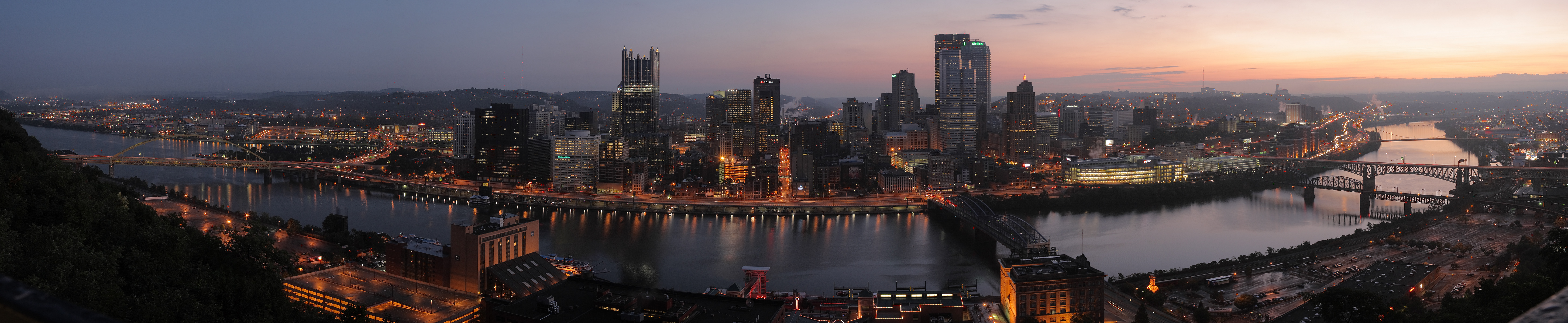
Mount Washington's famous view of downtown Pittsburgh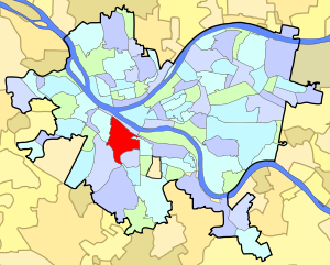
Neighborhood in Pittsburgh, PennsylvaniaCoordinates: 40°25′41″N 80°00′40″W / 40.428°N 80.011°W Population (1990): 10700[1] Population (2000): 9878[1] Area: 1.139 sq mi (2.95 km2)[1] Mount Washington is a neighborhood in Pittsburgh, Pennsylvania's south city area. It has a zip code of 15211 and has representation on Pittsburgh City Council by both the council members for District 3 (Central South Neighborhoods) and District 2 (West Neighborhoods).
It is known for its steep hill overlooking the Pittsburgh skyline, which was rated the second most beautiful vista in America by USA Weekend (and the best urban vista);[2] its funiculars, the Duquesne and Monongahela Inclines, which are the oldest continuous inclines in the world; and for the row of upscale restaurants paralleling the crest of Mount Washington, the hill the community sits upon. The neighborhood is also known as the home of Autumn House Press, one of the leading literary publishers in the United States.
Contents
History of Mount Washington
 A view of Mount Washington from Bigbee Street
In the early history of Pittsburgh, Mount Washington was known as Coal Hill, but Coal Hill was actually on the south bank of the Monongahela River.[3] Easy access to the Pittsburgh coal seam's outcrop near the base of Mt. Washington allowed several mines to operate there. Also, rock was quarried from the hill. Gray sandstone, for example, was quarried at Coal Hill for the second Allegheny County Courthouse.
By 1876, the name had been changed to Mount Washington,[4] and a year later, the view of the City of Pittsburgh was first drawn from Mt. Washington.[5] Almost all photos of the Pittsburgh skyline are from Mt. Washington, because of the view.[6]
Inclines
The meager roads that wound up the steep slopes of Mt. Washington were barely passable to a team of horses pulling a loaded wagon. Immigrants, predominantly from Germany, settled Mount Washington and worked in the plants adjacent to the Monongahela River. They became weary of climbing steep footpaths and steps to their homes, from the river valley, after work. They remembered the Seilbahns (inclines) of their former country, and proposals were advanced to construct one or more of them along Coal Hill. The Monongahela Incline was the first of these to be built in 1869–1870. The Duquesne Incline opened to the public in May 1877, and it was one of four inclined planes climbing Mount Washington that carried passengers and freight to the residential area that had spread along the top of the bluff. As the hilltop communities were virtually inaccessible by any other means, many of Pittsburgh's inclines carried horses and wagons as well as foot passengers. All carried some light freight. The last Pittsburgh-area incline to close was the Castle Shannon Incline, which closed in 1964. This incline also served Mount Washington, with a lower station at the corner of East Carson Street and Arlington Avenue, just east of the present Station Square Light Rail Station. This incline was closed by its owner, the Pittsburgh Railways Company, just prior to all of their streetcar and bus routes being taken-over by the Port Authority of Allegheny County.
The Monongahela and Duquesne Inclines allow access to Mt. Washington's overlook of the downtown area of Pittsburgh. Tourists marvel at the view while riding two of only a few remaining inclines in the country. The inclines remain the best way for thousands of Pittsburghers on Mt. Washington to get to their jobs, entertainment and shopping in downtown Pittsburgh and Station Square.
Chatham Village
One of the most famous examples of the early-twentieth century Garden City Movement communities is on Mt. Washington. Chatham Village is a compact neighborhood of townhomes and gardens on the far south end of Mt. Washington.
Services
The area is served by the Pittsburgh Bureau of Fire house number 27, equipped with a new 75-foot (23 m) Pierce Quint engine.[7]
Surrounding Pittsburgh neighborhoods
Allentown, Beechview, Beltzhoover, Duquesne Heights, South Shore
Beneath Mt. Washington
The first tunnel through Mt. Washington was the Pittsburgh and Castle Shannon Tunnel, which began life as a coal mine but was extended through from the Mt. Washington Coal Incline to Saw Mill Run in 1861. This was followed by the Mount Washington Transit Tunnel for Pittsburgh Railways and Wabash Tunnel for the Wabash Pittsburgh Terminal Railway, both in opening in 1904. The former continues in use by Pittsburgh Light Rail and the latter as an High Occupancy Vehicle tunnel.
The Liberty Tunnel through Mt. Washington opened in 1928.
The Fort Pitt Tunnel beneath and through Mt. Washington opened September 1, 1960.
Gallery
 Another view of the Pittsburgh skyline from the Mount Washington neighborhood.
 View of the Pittsburgh city from Grandview Avenue at Dawn
References
- ^ a b c Census: Pittsburgh. Pittsburgh Department of City Planning. January 2006. http://www.city.pittsburgh.pa.us/cp/assets/census/2000_census_pgh_jan06.pdf. Retrieved 2007-07-19.
- ^ "The 10 Most Beautiful Places in America". USA Weekend. May 18, 2003. http://www.usaweekend.com/article/99999999/LIVING01/91015001. Retrieved 2009-08-01.[dead link]
- ^ 1787 PLAN OF THE LOTS LAID OUT AT PITTSBURG AND THE COAL HILL http://www.mapsofpa.com/pittsburgh.htm
- ^ OUTLINE PLAN OF ALLEGHENY COUNTY http://www.mapsofpa.com/pitts/1876_0568a.jpg
- ^ 1877 BIRDSEYE VIEW OF PITTSBURGH http://www.mapsofpa.com/pitts/1877_1963.jpg
- ^ 1908 Panoramic photo http://www.mapsofpa.com/pitts/locphoto1908.jpg
- ^ "Firehouse No. 27 - Mt. Washington – Zone 4 – 27 Engine (Quint)/XQ27". http://www.pittsburghfire.net/news/?page_id=177. Retrieved December 8, 2009.
See also
External links
 Media related to Mount Washington (Pittsburgh) at Wikimedia Commons
- The MWCDC - Mount Washington Community Development Corporation
- Interactive Pittsburgh Neighborhoods Map
- 15211.org - A Community Blog About Mt. Washington
Categories:- Neighborhoods in Pittsburgh, Pennsylvania
- Economy of Pittsburgh, Pennsylvania
- Pittsburgh History & Landmarks Foundation Historic Landmarks
- Visitor attractions in Pittsburgh, Pennsylvania


Wikimedia Foundation. 2010.