- Vosges Mountains
-
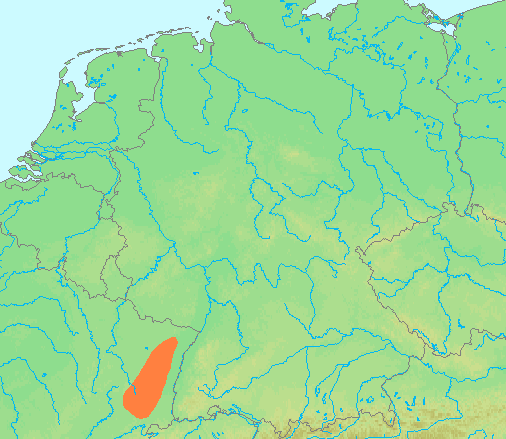
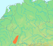 Location of the Vosges
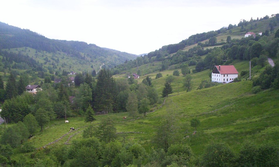
 Typical landscape of the Vosges (Chajoux valley, La Bresse, France)
 Waterfall in the eastern Vosges
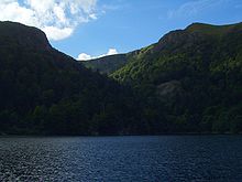 Lac de Schiessrothried, a glacial lake in the Vosges
For the department of France of the same name, see Vosges.
The Vosges (French pronunciation: [voːʒ]) (German: Vogesen, German pronunciation: [foˈgeːzn̩]) are a range of low mountains in eastern France, near its border with Germany. They extend along the west side of the Rhine valley in a northnortheast direction, mainly from Belfort to Saverne. The Grand Ballon is the highest peak at 1424m.
Contents
Geography
The elongated massif is divided south to north into three sections:
- the Higher Vosges (Hautes Vosges), extending in the southern part of the range from Belfort to the valley of the Bruche. The rounded summits of the Hautes Vosges are called ballons in French or "balloons".
- the sandstoned Vosges (50 km, or 31 miles), between the Permian Basin of Saint-Die including the Devon-Dinantian volcanic massif of Schirmeck-Moyenmoutier and the Col de Saverne
- the Lower Vosges (48 km, or 30 miles), between the Col de Saverne and the source of the Lauter.
In addition, the term "Central Vosges" is used to designate the various lines of summits, especially those above 1000 metres in elevation. The French department of Vosges is named after the range.
From a geological point of view, a graben in the beginning of the Tertiary area caused the formation of Alsace and the uplift of the plates of the Vosges now in eastern France and the Black Forest now in Germany. Strictly speaking scientifically, the Vosges Mountains are not mountains as such, but rather the western edge of the unfinished Alsatian graben, stretching continuously as part of the larger Tertiary formations. Erosive glacial action was the primary means by which the representative highland massif feature developed.
Geographically, the Vosges Mountains are located wholly in France far above the Col de Saverne separating them from the Palatinate Forest in Germany, which logically continues the same Vosges geologic structure but traditionally receives this different name for historical and political reasons.
The Vosges in their southern and central parts are called the Hautes Vosges. These consist of a large Carboniferous mountain eroded just before the Permian era with gneiss, granites, porphyritic masses or other volcanic intrusions. but in the north, south and west, there places less eroded by glaciers, and here Vosges Triassic and Permian red sandstone remains in large beds. The grès vosgien, (a French name for a Triassic rose sandstone) are embedded sometimes up to more than 500 metres in thickness. The Lower Vosges in north are dislocated plates of various sandstones, ranging from 300 to 600 metres (1000 to 1850 ft.) high.
The highest points are located in the Hautes Vosges: the Grand Ballon in ancient times called Ballon de Guebwiller or Ballon de Murbach rises to 1424 m (4,670 ft), the Storckenkopf to 1366 m (4,481 ft), the Hohneck to 1364 m (4,475 ft), and the Ballon d'Alsace to 1247 m (4,091 ft). The Col de Saales, between the Higher and Central Vosges, reaches nearly 579 m (1,900 ft), both lower and narrower than the Higher Vosges, with Mont Donon (1008 m, 3307 ft.) being the highest point of this Nordic section.
There is a remarkable similarity between the Vosges and the corresponding range of the Black Forest on the other side of the Rhine: both lie within the same degrees of latitude, have similar geological formations and are characterized by forests on their lower slopes, above which are open pastures and rounded summits of a rather uniform altitude; furthermore, both exhibit steeper slopes towards the Rhine and a more gradual descent on the other side. This occurs because both the Vosges and the Black Forest were formed by isostatic uplift, in a response to the opening of the Rhine Graben. The Rhine Graben is a major extensional basin. When such basins form, the thinning of the crust causes uplift immediately adjacent to the basin. The amount of uplift decreases with distance from the basin, causing the highest range of peaks to be immediately adjacent to the basin, and the increasingly lower mountains to stretch away from the basin.
Climate
Meteorologically, the difference between the eastern and western mean slopes of the range is very marked. The main air streams come generally from the west and south-west, so the Alsatian central plains just under the Hautes-Vosges receive much less water than the south-west front of the Vosges Mountains. The highlands of the arrondissement of Remiremont receive as annual rainfall or snowfall more than 2 metres of water yearly, whereas some dry country near Colmar receives less than 500 mm of water in the event of insufficient storms. The temperature is much lower in the west front of the mountains than in the low plains behind the massif, especially in summer. On the eastern slope economic vineyards reach to a height of 400 metres (1300 ft.); on the other hand, in the mountains, it is a land of pasture and forest.
The only rivers in Alsace are the Ill coming from south Alsace (or Sundgau), and the Bruche d'Andlau and the Bruche which have as tributaries other, shorter but sometimes powerful streams coming like the last two from the Vosges Mountains. The Moselle, Meurthe and Sarre rivers and theirs numerous affluents all rise on the Lorraine side.
In the High Moselle and Meurthe basins, moraines, boulders and polished rocks testify to the existence of ancient glaciers which formerly covered the top of the Vosges. The mountain lakes caused by the original glaciation phenomena are surrounded by pines, beeches and maples, and green meadows provide pasture for large herds of cattle, with views of the Rhine valley, the Black Forest and the distant, snow-covered Swiss mountains.
History
The massif known in Latin as Vosago mons or Vosego silva, sometimes Vogesus mons, was extended to the vast woods covering the region. Later, German speakers referred to the same region as Vogesen or Wasgenwald.
On the lower heights and buttresses of the main chain on the Alsatian side are numerous castles, generally in ruins, testifying the importance of this crucial crossroads of Europe, violently contested for centuries. At several points on the main ridge, especially at Sainte Odile above Ribeauvillé (German: Rappoltsweiler), are the remains of a wall of unmortared stone with tenons of wood, about 1.8 to 2.2 meters (6 to 7 ft.) thick and 1.3 to 1.7 meters (4 to 5 ft.) high, called the Mur Païen (Pagan Wall). It was used for defence in the Middle Ages and archaeologists are divided as to whether it was built by the Romans, or before their arrival.
From 1871 to 1918, the Vosges formed the main border line between France and the German Empire. The demarcation line stretched from the Ballon d'Alsace to Mont Donon with the lands east of it being incorporated into Germany as part of Alsace-Lorraine.
During the French Revolutionary Wars, on 13 July 1794, the Vosges were the scene of the Battle of the Vosges. During the First World War, they were the scene of severe and almost continuous fighting.[1] And during the Second World War, in autumn 1944, they were the site of brief but sharp fighting between Franco-American and German forces.
References and notes
- ^
 "Vosges Mountains". Collier's New Encyclopedia. 1921.
- Chisholm, Hugh, ed (1911). "Vosges (mountains)". Encyclopædia Britannica (11th ed.). Cambridge University Press.
Bibliography
General Texts :
- René Bastien, Histoire de Lorraine, éditions Serpenoise, Metz, 1991, 224 pages. ISBN 2-87692-088-3 (simple historic approach for children)
- Etienne Julliard, Atlas et géographie de l'Alsace et de la Lorraine, Flammarion, 1977, 288 pages ( a geogropher's view of this part of France who gives theirs waters to Rhin)
- Robert Parisot, Histoire de Lorraine (Meurthe, Meuse, Moselle, Vosges), Tome 1 à 4 et index alphabétique général, Auguste Picard éditeur, Paris, 1924. Anastaltic impression in Belgium by the éditions Culture et Civilisation, Bruxelles, 1978. (large and more sophisticated evenemential history)
- Yves Sell (dir.), L'Alsace et les Vosges, géologie, milieux naturels, flore et faune, La bibliothèque du naturaliste, Delachaux et Niestlé, Lausanne, 1998, 352 pages. ISBN 2-603-01100-6 (global view of nature and land)
- Jean-Paul von Eller, Guide géologique Vosges-Alsace, guide régionaux, collection dirigée par Charles Pomerol, 2° édition, Masson, Paris, 1984, 184 pages. ISBN 2-225-78496-5 (a precise geologic description)
List of majors periodicals concerning Lorraine and South Lorraine:
- Annales de l'Est (et du Nord), Nancy.
- Annales de la Société d'Émulation des Vosges, Epinal, from 1826.
- Bulletin de la Société Philomatique Vosgienne, Saint-Dié, from 1875 to 1999 (nowadays Mémoire des Vosges Histoire Société Coutumes)
- Publications of the Société d'Histoire et d'Archéologie lorraine, Metz (from 1890, nowadays Les Cahiers Lorrains, trimestrial review).
- Publications of the Société d'Histoire de la Lorraine & Musée Lorrain, Nancy (Lotharingist wrintings since 1820, nowadays trimestrial périodical, Le Pays Lorrain)
On the First World War :
- Guide des sources de la Grande Guerre dans le département des Vosges, Conseil général de Vosges, Epinal, 2008, 296 pages. ISBN 978-2-86088-062-6
- Isabelle Chave (dir.) avec Magali Delavenne, Jean-Claude Fombaron, Philippe Nivet, Yann Prouillet, La Grande Guerre dans les Vosges : sources et état des lieux, Actes du colloque tenu à Epinal du 4 au 6 septembre 2008, Conseil général des Vosges, 2009, 348 pages. ISBN 978-2-86088-067-1
- "La guerre aérienne dans les Vosges. 1914-1919", Mémoire des Vosges H.S.C. édité par la Société Philomatique Vosgienne, [hors série n°5, septembre 2009], 68 pages. ISSN 1626-5238
External links
Alps · Armorican Massif · Ardennes · Corsica · Jura Mountains · Massif Central · Morvan · Pyrenées · Vosges Mountains
 Categories:
- Mountain ranges of France
- Biosphere reserves of France


Wikimedia Foundation. 2010.