- Chaddesley Corbett
-
Coordinates: 52°21′39″N 2°09′35″W / 52.360725°N 2.159672°W
Chaddesley Corbett 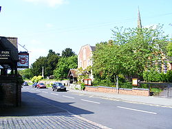
Chaddesley Corbett from The Talbot showing the Church and school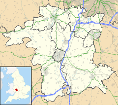
 Chaddesley Corbett
Chaddesley Corbett shown within WorcestershireParish Chaddesley Corbett District Wyre Forest Shire county Worcestershire Region West Midlands Country England Sovereign state United Kingdom Post town Kidderminster Postcode district DY10 EU Parliament West Midlands List of places: UK • England • Worcestershire Chaddesley Corbett is a village and civil parish in the Wyre Forest District of Worcestershire, England. The civil parish also includes the settlements of Bluntington, Brockencote, Mustow Green, Cakebole, Outwood, Harvington, and Drayton.
Contents
Location, geography, history, demographics
Chaddesley Corbett is situated on the north side of the A448 approximately mid-way between the north Worcestershire towns of Bromsgrove and Kidderminster. The village was named Chad Lea, or the place of Chad, in Saxon times,[1] and is recorded in the Domesday Book of 1086-7 as Cedeslai, when it was held by a woman, Eadgifu, who also held it in the time of King Edward before the Norman Conquest of 1066.[2] It consisted of eight berewicks and 25 hides of which 10 were free of geld and had the value of £12.[2] The area was subject to forest law for around a century to 1301, as part of Feckenham Forest.[3]
Chaddesley Corbett had a population of 1343 persons and 280 houses in 1821.[4]
The parish had a population of 1,440 persons and 607 households in 2001.[5]
Village general description and features
Within the village urban area is the Church of England church of St Cassian. There is also a Methodist Chapel in Bluntington and a Catholic chapel associated with Harvington Hall. The three village pubs, The Talbot, The Swan and The Fox were named in the 2007 Good Beer Guide.[6]
There is also a Post Office and General Store named Samuel Jukes after a previous owner, a butcher, hairdresser and beauty salon, a flower shop and a delicatessen. Local services include a GP surgery and two schools, one being Chaddesley Corbett Primary School, the other being the independent Winterfold House School. The primary school caters for Reception to Year 6 and replaced the previous Chaddesley Corbett Endowed First School under the Wyre Forest education review. Each school has an associated pre-school nursery.
Chaddesley Corbett Sports Club is located in Fox Lane and has rugby, football and cricket sections, all of which play in one or more local leagues.
The village is the location for the Lady Dudley Cup, a point to point race that was first run in 1897.[7]
Chaddesley Woods is an area of woodland and nature reserve to the east of the village, thought to be a remnant of the medieval Feckenham Forest. It is under the care of the Worcestershire Wildlife Trust, founded in 1968 to conserve, protect and restore the county's wildlife. The main section of the woods has a network of public footpaths to facilitate access. [8]
St Cassian's Church
 Chaddesley Corbett Church from lytch gate
 Interior of Chaddesley Corbett Church
While references in the Domesday Book imply that there was a church at Chaddesley Corbett before that date, the present nave dates from the 12th century with later additions. [9] Additions and alterations followed in succeeding centuries. For example, the St Nicholas Chapel added in the 13th century; chancel, north aisle and south aisle added in the 14th century; vestry (probably) added in the 16th century when the south aisle and St Nicholas Chapel were also altered; the tower and spire added in the 18th century; north aisle widened and vestry altered in the 19th century. [10]
20th and 21st century alterations include repairs, improvements, and other memorials. Amongst these are a large Roll of Honour, listing those who served in World War I, housed in the tower which is also the main entrance to the nave, and two windows commemorating soldiers killed during World War II. The pipes of the organ were relocated to a gallery at the west end of the nave when the St Nicholas Chapel was refurnished. There is now a small kitchen in the choir vestry, and a toilet meeting modern standards under the D.D.A. The pipe organ, currently 3 manuals plus pedals, was first built in 1817 and relocated from a west gallery during major restoration and alterations in 1863-4. [11]
The monuments begin with those to members of the Corbett family, local lords of the manor and benefactors of the church. A wide variety of other people are also commemorated. The set of three tablets listing the Wheelers and Harwards of Winterfold is an interesting example. Other memorials are in stained glass windows, of which the south chancel window is a fine example. The south aisle wall leans significantly, and is supported by a substantial flying buttress. This happens to be located the other side of the wall from the Wheeler-Harward tablets.
The Norman stone font is thought to be the work of the Herefordshire School of sculptors, active c.1125-1150, which drew on Romanesque models from southern Europe. It features a main motif of interlaced dragons—symbolising, perhaps, the evil of original sin which is washed away in baptism—with other interlacing patterns along the rim and base. The dragons resemble Romanesque north Italian models, especially the pulpit of San Giulio abbey in Piedmont, but their interlacing is a motif of indigenous Anglo-Irish origin.[12]
-

Chaddesley Corbett Church, Norman font
-

Chaddesley Corbett Church, WWI roll of honour
-

Chaddesley Corbett Church, Wheeler-Harward memorials
-

Chaddesley Corbett Church, south chancel window
-

Chaddesley Corbett Church, flying buttress
Famous residents
- Jim Yardley was born in Chaddesley Corbett and played cricket for Chaddesley Corbett CC before going on to play first-class cricket for Worcestershire, and Northamptonshire. [13]
- Ernest Perry, first-class cricketer, was born in Chaddesley Corbett.
References
- ^ Noake, John (1868). J Noake's Guide to Worcestershire. London: Longman. p. 82. ISBN 9780141439945. http://www.users.totalise.co.uk/~fortroyal/NoakeGuide/82.html.
- ^ a b Williams, Ann; G H Martin (2002). Domesday Book: A Complete Translation. London: Penguin. pp. 492; 1326. ISBN 9780141439945.
- ^ Humphreys FSA, John. "Forest of Feckenham". Transactions and proceedings (Birmingham and Warwickshire Archaeology Society) 44-45: 115–132. (page 120)
- ^ Tymm, Samuel (1834). The Family Topographer: Being a Compendious Account of the Antient and Present State of the Counties of England. London: J.B. Nichols and Son. p. 280. http://books.google.co.uk/books?id=qcouAAAAMAAJ&pg=PA280&dq=%22Chaddesley+Corbett%22&lr=&ei=HNQvSOfcOoGuywTTjYTXAw#PPA280,M1. Retrieved 2008-05-18.
- ^ United Kingdom Census 2001. "Chaddesley Corbett CP (Parish)". Office for National Statistics. http://www.neighbourhood.statistics.gov.uk/dissemination/LeadTableView.do?a=7&b=800969&c=Chaddesley+Corbett&d=16&e=15&g=500425&i=1001x1003x1004&m=0&r=1&s=1201312146842&enc=1&dsFamilyId=779. Retrieved 2008-01-26.
- ^ Smith, Adam (2006-09-26). "Village is hailed for its great ale". Birmingham Mail. http://www.highbeam.com/doc/1G1-151899270.html. Retrieved 2008-01-07.
- ^ Connaughton, Mick (2006-04-01). "Horse Racing: Cannon Bridge to extend winning run in Cup". The Independent. http://findarticles.com/p/articles/mi_qn4158/is_20060401/ai_n16204243. Retrieved 2008-01-07.[dead link]
- ^ Surveyed in August 2008 for Open Street Map, Chaddesley Wood.
- ^ Roper, John S., A History of St Cassian's Church Chaddesley Corbett,2006, The Friends of St Cassian's Church (£2, May 2009), p.3
- ^ Roper, op. cit., p.36
- ^ Roper, op. cit., pp. 19, 31
- ^ G. Zarnecki, "Germanic Animal Motifs in Romanesque Sculpture", Artibus et historiae 22 (1990), pp. 189-203
- ^ Wisden Cricketers' Almanack
Towns Villages Areley Kings • Astley Cross • Axborough • Blakedown • Blakeshall • Bliss Gate • Broome • Caunsall • Chaddesley Corbett • Churchill • Clows Top • Cookley • Drayton • Franche • Heightington • Kingsford • Ribbesford • Rock • Rushock • Shenstone • Stone • Tanwood • Upper Arley • WolverleyCivil parishes Categories:- Villages in Worcestershire
-


Wikimedia Foundation. 2010.