- Olympic Coast National Marine Sanctuary
-
Olympic Coast National Marine Sanctuary IUCN Category IV (Habitat/Species Management Area)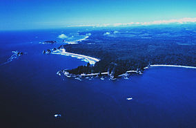
Aerial view of Teahwhit Head and James IslandLocation Western Washington state Coordinates 48°00′N 124°48′W / 48°N 124.8°WCoordinates: 48°00′N 124°48′W / 48°N 124.8°W Area 3,189 sq mi (8,260 km2)[1] Established 1994 Governing body National Oceanic and Atmospheric Administration The Olympic Coast National Marine Sanctuary is one of 14 marine sanctuaries administered by the National Oceanic and Atmospheric Administration (NOAA), an agency of the U.S. Department of Commerce. It is located along the Olympic Peninsula of Washington state. The sanctuary was declared in 1994 and encompasses 3,189 square miles (8,260 km2) of the Pacific Ocean from Cape Flattery in the north, to the mouth of the Copalis River, a distance of about 162.5 miles (261.5 km).[1] Extending 25 to 40 miles (40 to 64 km) from the shore, it includes most of the continental shelf, as well as parts of three important submarine canyons, the Nitinat Canyon, the Quinault Canyon and the Juan de Fuca Canyon. For 64 miles (103 km) along the coast, the sanctuary shares stewardship with the Olympic National Park.[1] The sanctuary overlays the Flattery Rocks, Quillayute Needles, and Copalis Rock National Wildlife Refuges.[2]
References
- ^ a b c "Mapping". Olympic Coast National Marine Sanctuary. http://olympiccoast.noaa.gov/living/maps.html.
- ^ "Sanctuary Fact Sheet". Olympic Coast National Marine Sanctuary. http://olympiccoast.noaa.gov/AboutUs/factsheet.html.
External links
 Map of the sanctuary
 Olympic Coast National Marine Sanctuary
Protected Areas of Washington Federal National ParksNational MonumentsEbey's Landing National Historical Reserve · Fairhaven Historic District · Pioneer Square Historic District · Vancouver National Historic Reserve Historic District
National Recreation AreasNational Wildlife RefugesColumbia · Conboy Lake · Copalis · Dungeness · Flattery Rocks · Franz Lake · Grays Harbor · Julia Butler Hansen Refuge for the Columbian White-Tailed Deer · Lewis and Clark · Little Pend Oreille · McNary · Nisqually · Pierce · Protection Island · Quillayute Needles · Ridgefield · Saddle Mountain · San Juan Islands · Steigerwald Lake · Toppenish · Turnbull · Umatilla · Willapa
National WildernessAlpine Lakes · Boulder River · Brothers · Buckhorn · Clearwater · Colonel Bob · Glacier Peak · Glacier View · Goat Rocks · Henry M. Jackson · Indian Heaven · Juniper Dunes · Lake Chelan-Sawtooth Ridge · Mount Adams · Mount Baker · Mount Rainier · Mount Skokomish · Noisy-Diobsud · Norse Peak · Olympic · Pasayten · Salmo-Priest · San Juan · Stephen Mather · Tatoosh · Trapper Creek · Washington Islands · Wenaha–Tucannon · Wild Sky · William O. Douglas · Wonder Mountain
Olympic Coast National Marine Sanctuary · Padilla Bay National Estuarine Research Reserve
State Alta Lake · Anderson Lake · Battle Ground Lake · Bay View · Beacon Rock · Belfair · Birch Bay · Blake Island · Blind Island · Bogachiel · Bottle Beach · Bridgeport · Bridle Trails · Brooks Memorial · Cama Beach · Camano Island · Camp Wooten Environmental Learning Center · Cape Disappointment · Centennial Trail · Clark Island · Columbia Hills · Columbia Plateau Trail · Conconully · Crawford · Curlew Lake · Cutts Island · Damon Point · Daroga · Dash Point · Deception Pass · Dosewallips · Doug's Beach · Eagle Island · Fay Bainbridge · Federation Forest · Fields Spring · Flaming Geyser · Fort Casey · Fort Columbia · Fort Ebey · Fort Flagler · Fort Okanogan · Fort Simcoe · Fort Townsend · Fort Ward · Fort Worden · Ginkgo Petrified Forest · Goldendale Observatory · Grayland Beach · Griffin Bay · Griffiths-Priday · Harstine Island · Hope Island (Mason County) · Hope Island (Skagit County) · Ike Kinswa · Illahee · Iron Horse · James Island · Jarrell Cove · Joemma Beach · Jones Island · Joseph Whidbey · Kanaskat-Palmer · Kinney Point · Kitsap Memorial · Kopachuck · Lake Chelan · Lake Easton · Lake Sammamish · Lake Sylvia · Lake Wenatchee · Larrabee · Leadbetter Point · Lewis and Clark · Lewis and Clark Trail · Lime Kiln Point · Lincoln Rock · Manchester · Maryhill · Matia Island · McMicken Island · Millersylvania · Moran · Mount Pilchuck · Mount Spokane · Mystery Bay · Nine Mile Recreation Area · Nolte · Ocean City · Olallie · Olmstead Place · Osoyoos Lake · Pacific Beach · Pacific Pines · Palouse Falls · Paradise Point · Patos Island · Peace Arch · Pearrygin Lake · Penrose Point · Peshastin Pinnacles · Pleasant Harbor · Posey Island · Potholes · Potlatch · Rainbow Falls · Rasar · Reed Island · Riverside · Rockport · Sacajawea · Saint Edward · Saltwater · Scenic Beach · Schafer · Seaquest · Sequim Bay · Shine Tidelands · Skagit Island · Skull Island · South Whidbey · Spencer Spit · Squak Mountain · Squilchuck · Steamboat Rock · Steptoe Battlefield · Steptoe Butte · Stretch Point · Stuart Island · Sucia Island · Sun Lakes · Tolmie · Triton Cove · Turn Island · Twanoh · Twenty-Five Mile Creek · Twin Harbors · Upright Channel · Wallace Falls · Wanapum Recreational Area · Wenatchee Confluence · Westport Light · Yakima Sportsman
Ahtanum · Capitol · Elbe Hills · Green Mountain · Loomis · Loup Loup · Tahoma · Tahuya · Tiger Mountain · Yacolt Burn
Admiralty Inlet · Badger Gulch · Bald Hill · Barker Mountain · Bone River · Camas Meadows · Carlisle Bog · Castle Rock · Charley Creek · Chehalis River Surge Plain · Chopaka Mountain · Clearwater Bogs · Cleveland Shrub Steppe · Columbia Falls · Columbia Hills · Cypress Highlands · Dabob Bay · Dailey Prairie · Davis Canyon · Entiat Slopes · Goose Island · Gunpowder Island · Kahlotus Ridgetop · Kennedy Creek · Kings Lake Bog · Kitsap Forest · Little Pend Oreille River · Marcellus Shrub Steppe · Methow Rapids · Mima Mounds · Monte Cristo · Niawiakum River · North Bay · Oak Patch · Olivine Bridge · Pinecroft · Point Doughty · Riverside Breaks · Rocky Prairie · Sand Island · Schumacher Creek · Selah Cliffs · Skagit Bald Eagle · Skookum Inlet · Snoqualmie Bog · Spring Creek Canyon · Trout Lake · The Two-Steppe · Upper Dry Gulch · Washougal Oaks Natural Area · Whitcomb Flats · Willapa Divide
Cattle Point · Clearwater Corridor · Cypress Island · Devils Lake · Dishman Hills · Elk River · Ellsworth Creek · Granite Lakes · Hat Island · Hendrickson Canyon · Klickitat Canyon · Lake Louise · Loomis · Lummi Island · Merrill Lake · Morning Star · Mount Si · Rattlesnake Mountain Scenic Area · Shipwreck Point · South Nemah · South Nolan · Stavis · Table Mountain · Tahoma Forest · Teal Slough · Washougal Oaks Natural Area · West Tiger Mountain · White Salmon Oak · Woodard Bay
Other Former state parksLyons Ferry Park · Mukilteo Lighthouse Park · Wenberg County Park
Blanchard Forest · Cascadia Marine Trail · The Enchantments · Goose Island · Sehome Hill Arboretum · Withrow Moraine · Yellow Island
Categories:- IUCN Category IV
- Protected areas of Clallam County, Washington
- Protected areas of Grays Harbor County, Washington
- Protected areas of Jefferson County, Washington
- National Marine Sanctuaries of the United States


Wikimedia Foundation. 2010.