- Old Sodbury
-
Coordinates: 51°32′01″N 2°21′22″W / 51.533601°N 2.356147°W
Old Sodbury 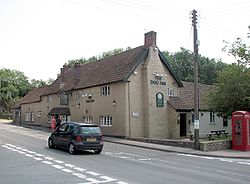
The Dog Inn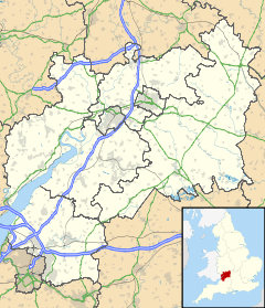
 Old Sodbury
Old Sodbury shown within GloucestershireOS grid reference ST726822 Unitary authority South Gloucestershire Ceremonial county Gloucestershire Region South West Country England Sovereign state United Kingdom Post town BRISTOL Postcode district BS37 Dialling code 01454 Police Avon and Somerset Fire Avon Ambulance Great Western EU Parliament South West England UK Parliament Northavon List of places: UK • England • Gloucestershire  The church of St. John the Baptist
 The Church of England School
Old Sodbury is a small village in the valley of the River Frome just below and to the west of the Cotswold escarpment and to the east of Chipping Sodbury and Yate in South Gloucestershire, England. The village extends from Chipping Sodbury in the West to the Cotswold Edge in the East and is on the Cotswold Way. The Badminton Road (A432) winds eastwards through the village, up to its junction with the A46, which broadly follows the line of the Fosseway and runs along the top of the Cotswold escarpment (from Bath to Stroud).
The village lies on an old coaching route, and is much more ancient than its westerly neighbour, Chipping Sodbury: hence the name 'Old' Sodbury.
Contents
Name and fort
The name of the village is recorded in Anglo-Saxon (in the dative case) as Soppanbyrig = "Soppa's fort" and in Domesday Book as Sopeberie. The name may refer to the Iron Age hill fort just to the north-east of the village. The fort, perched on the edge of the Cotswold escarpment, is enclosed on three sides by two parallel earthworks, and is open to the west, commanding an impressive view of the Frome Valley, Severn Vale and the Welsh mountains. The earth walls enclose an area of 11 acres (45,000 m2), and are usually kept mown by the local farmer (the fort is in private hands, but accessible). The fort can be reached by footpath from the A46 road, and through the village from below via the Cotswold Way. Below the fort are a group of ancient pillow mounds which are supposed to have been created by people who hoped rabbits would develop warrens there - providing a source of meat.
The Romans strengthened the fort for use as a camp to support their western frontier. In AD 577 the Saxon army used the fort as a camp before the battle of Dyrham, a few miles to the south. King Edward IV camped here in 1471 before attacking the army of Margaret of Anjou at the Battle of Tewkesbury.
Church
The Church of Saint John the Baptist is late Norman or Transitional, and is some 900 years old. It has two effigies of knights: one is late 14th century, carved in wood; and the other is dated to 1240, carved in stone, featuring a very large shield. These two are considered to have been lords of the local manor.
In the churchyard at Old Sodbury are a number of old bale-tombs; these were tombs for rich merchants. Some of the gravestones date back to the early 19th century. Just outside the churchyard on the hillside is a topograph (a large stone with an engraving), installed to commemorate the second millennium, that shows Old Sodbury in relation to its geographical surroundings.
Other buildings
There are two primary schools (Old Sodbury CofE Primary School, and the privately run Overndale School), two hotels, and two pubs, The Bell Hotel and The Dog Inn. The village has a petrol station, a football pitch and a playground, but sadly no longer a post office since the last round of closures in 2008, although the village shop still survives in the same premises on the Badminton Road. The historic Cross Hands Hotel stands on the North-Eastern corner of the A46 crossroads, and there is a farm shop (Cotswold Edge) opposite the hotel.
There is a crenellated tower on the escarpment immediately above and to the East of the village, resembling a rook chesspiece, visible from the main road, that performs the function of a ventilation shaft (the first of six) for the Chipping Sodbury Tunnel, on the main railway line from South Wales, via Bristol Parkway to London Paddington). These shafts were designed by Isambard Kingdom Brunel for the Great Western Railway, which runs through the village and under the hill above it. The line originally ran between Chipping Sodbury and Badminton stations, which were closed around the time of the Beeching axe. Now, the nearest station is Yate on the main line from Bristol to Birmingham, which intersects the Great Western Railway to the South of Yate.
Lyegrove House is 17th century in origin, altered in the 19th and 20th centuries. The Lodge is Gothic of 1835 by Charles Dyer of Bristol.
References
- David Verey, Gloucestershire: the Cotswolds, The Buildings of England edited by Nikolaus Pevsner, 2nd ed. (1979) ISBN 0-14-071040-X, p. 351-353
External links
- Sodbury Players - local amateur dramatics group in the Yate and Chipping Sodbury Area
Categories:- Villages in South Gloucestershire


Wikimedia Foundation. 2010.