- Carloway
-
Coordinates: 58°16′N 6°46′W / 58.27°N 6.77°W
Carloway Scottish Gaelic: Càrlabhagh 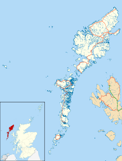
 Carloway
Carloway shown within the Outer HebridesPopulation 500 (approx.) Language Scottish Gaelic English Council area Na h-Eileanan Siar Lieutenancy area Western Isles Country Scotland Sovereign state United Kingdom Post town STORNOWAY Postcode district HS2 Dialling code 01851 Police Northern Fire Highlands and Islands Ambulance Scottish EU Parliament Scotland UK Parliament Na h-Eileanan an Iar Scottish Parliament Western Isles List of places: UK • Scotland • 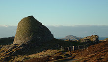
Carloway (Scottish Gaelic: Càrlabhagh) is a district situated in the parish of Uig on the west coast of the Isle of Lewis, in the Outer Hebrides. The district has a population of around 500.
Contents
The District
Carloway is very attractive for tourism, with many historic sites to see, such as the Garenin Blackhouse Village or Doune Carloway Broch.
The Carloway Bridge is said to be one of Scotland's oldest flyovers, being built in the mid-19th century. The bridge crosses the Carloway River and the Pentland Road, which leads to the Carloway Pier and Harbour or to Stornoway the other way.
The district of Carloway (after the village of that name) which hitherto had fallen partly within the parishes of Lochs and Uig, became a separate civil registration district in 1859.
The district is divided into eight townships: Knock Carloway, Park Carloway, Doune Carloway, Upper Carloway, Garenin, Borrowston, Kirivick and Dalmore. The Estate starts at the cattle grid between Garynahine and Callanish and ends at the Bragar cattle grid, just leaving Shawbost towards Bragar.
Carloway has a few historical sites. A pictish Broch in Doune Carloway, a Blackhouse Village in Garenin and many others, including a standing stone called "Clach an Tursa" in Upper Carloway.
Public services include a primary school, a youth hostel, a police station, hotels, restaurants, a newly renovated Harris Tweed mill, a pier, a surgery and day centre, a museum, a community centre, two churches (The Free Church of Scotland and The Church of Scotland), a football pitch, a war memorial and a historical society. Plans for a petrol station and convenience store have been proposed.
The district is known throughout the Western Isles for it's Agricultural Show and Highland Games, held annually on the first Wednesday of August at the Show Ground, behind Carloway School in the centre. In 2011, the 58th Agricultural Show took place with 2,500 people attending, more than the previous year's attendance. It is the longest running agricultural show on the island, first held in 1911 and officially the oldest since Beinn-na-Driobh agricultural show stopped in Stornoway. It is locally known as the island's "Premiere Show".
There are three routes that connect Carloway with the main town of Stornoway. The first route is the main road heading north, which passes through Shawbost, Bragar and Barvas, where it splits one way going to Stornoway and another way going to Ness. The second route is the main road heading south which passes through Breasclete, Callanish and Leurbost, which again splits one way to Stornoway and another way to both Balallan and Tarbert, Harris. The third and most popular, faster route from Carloway to Stornoway is the single track Pentland road, which goes to Stornoway straight across the island's Pentland Moor.
Climate
Climate data for Carloway Month Jan Feb Mar Apr May Jun Jul Aug Sep Oct Nov Dec Year Average high °C (°F) 8
(46)8
(46)8
(46)10
(50)13
(55)14
(57)16
(61)16
(61)15
(59)12
(54)10
(50)8
(46)11.5
(52.7)Average low °C (°F) 2
(36)1
(34)1
(34)3
(37)4
(39)7
(45)8
(46)8
(46)6
(43)4
(39)3
(37)1
(34)4.0
(39.2)Rainfall mm (inches) 143
(5.63)117
(4.61)109
(4.29)78
(3.07)62
(2.44)72
(2.83)72
(2.83)86
(3.39)93
(3.66)127
(5)131
(5.16)114
(4.49)1,204
(47.4)[citation needed] Religion
The district has two churches, both of which are located near the Carloway Bridge in the Knock Carloway township. The Free Church of Scotland was built in 1884 and has a congregation of up to 100 people. Services are conducted in both English and Scottish Gaelic by Rev. Kenneth MacLeod. The Church of Scotland is next door to the Free Church and was built in 1908. It has a congregation with just over 50 people, with services conducted in English by Rev. Stephen MacDonald.
Football
Football is by far the most favoured sport in the area. Carloway FC was founded in 1933 and first constituted in 1946 after the Second World War, playing their games on turf at Altan Feirigro in Garenin, before relocating to land near Cnoc a'Chailich in Upper Carloway. The club's catchment area covers communities between Dalmore and Breanish, more or less being the Parish of Uig. The club won its first trophy in 1952 after beating league champions Point 5-1 to win the Stornoway Cup. Between 1955 and 1957, Carloway won several more trophies; 5-1 against Back to win the D'Oyle Carte Cup and 4-1 against Point to win the Tormod Mor Tankard, both in 1956. The following year they defeated Stornoway United to win the Stornoway Cup for the second time. During that period it was rare to see a final without the involvement of the club, with the Eilean Fhraoich Cup Final seeing Carloway three years in a row, despite the club failing to win. Since this successful period in the 1950s the club has not won another trophy, despite taking part in several finals. Today, the club stands in a promising position of achieving the aim of winning another trophy, having secured a high place in the league in every year since 2008. The club boasts the largest support in the Western Isles and indeed the best playing surface for an amateur team in the Highlands and Islands, which was opened in 1991 with a friendly against Rangers reserves. The match attracted 1100 spectators to the newly-built pitch, which had been renovated twice (1949–51 and 1991) since it was built in 1935. Two players who have played for Carloway went on to play football at professional level; Ronnie MacKinnon who played for Rangers and Scotland, and his brother Donnie, who played for Partick Thistle.
The club has a website: http://www.carlowayfc.co.uk
Carloway Townships
The District of Carloway Sgìre Chàrlabhaigh Townships Bailtean Borrowston Borghastan Dalmore Dail Mòr Doune Carloway Dùn Chàrlabhaigh Garenin Na Gearrannan Kirivick Cìrbhig Knock Carloway Cnoc Chàrlabhaigh Park Carloway Pairc Chàrlabhaigh Upper Carloway Mullach Chàrlabhaigh Notable Carlowegians and people connected with the district
- Lord Carloway (Colin John Maclean Sutherland) - one of Scotland's top judges
- Norrie MacIver - member of Scottish band Bodega
- Christine Primrose - singer, disc jockey, actress and music producer
- Alex MacDonald - Convenor of the Western Isles and Comhairle nan Eilean Siar (Western Isles Council)
- Neen MacKay (Neen NicAoidh) - Gaelic TV presenter
- Angus MacInnes - actor, plays Sonny Munro in the Scottish soap River City, mother comes from Borrowston, Carloway.
- John MacKay - main anchor on Central edition of STV News at Six (STV), mother comes from Garenin, Carloway.
- Willie MacKay - football agent, father comes from Kirivick, Carloway.
- Ronnie MacKinnon - ex-Rangers, Scotland National Football Team and Carloway player - 1960s (twin brother of Partick Thistle player, Donnie MacKinnon). Their mother was from Upper Carloway.
- Donnie MacKinnon - ex-Partick Thistle player (twin brother of Ronnie McKinnon).
- Finlay MacNeil - Gaelic singer, otherwise known as "Fionnlaigh Mor" in Gaelic.
Categories:


Wikimedia Foundation. 2010.