- South Road, Adelaide
-
South Road 

South Road Underpass beneath Anzac Highway Length 115 km (71 mi) Direction North–South From  Salisbury Highway /
 Port River Expressway, Wingfield, Adelaide
via Croydon, Hindmarsh, Mile End, Reynella, Morphett Vale, Old Noarlunga, Aldinga, Sellicks Hill, Yankalilla To  Cape Jervis-Noarlunga Road, Cape Jervis, South Australia
via Ferry to Kangaroo IslandAllocation  Wingfield - Old Noarlunga
 Old Noarlunga - Cape Jervis
Major junctions Grand Junction Road,
Port Road,
Sir Donald Bradman Drive,
Anzac Highway,
Cross Road,
Southern Expressway,
Victor Harbor Road, Yankalilla-Victor Harbor Road The Southern Expressway's northern end joins Main South Road. The direction of the expressway alternates to ease congestion on South Road.
South Road (route A13, B23) is a major north–south conduit in Adelaide, South Australia. Also known as Main South Road, it is Adelaide's most important arterial road.
Contents
Route
South Road carries much of the road traffic from the southern suburbs towards the Adelaide city centre. This traffic completes its journey to the city centre via Anzac Highway.
From Anzac Hwy, South Road continues north as a western bypass of the city across many arterials, the major ones being Port Road, Regency Road and Grand Junction Road, to the junctions with the Port River Expressway and the Salisbury Highway. Until the Port River Expressway opened in 2005, the sections of South Road and Salisbury Highway between Grand Junction Road and Port Wakefield Road were known as the South Road Extension, built in the early 1990s.
To the south of Anzac Hwy, the name changes to Main South Road at the intersection of Ayliffes and Shepherds Hill Roads at Clovelly Park, and continues past McLaren Vale (where the Victor Harbor road branches off) and runs parallel to the west coast of Fleurieu Peninsula all the way to Cape Jervis at its southern tip. The town of Old Noarlunga, South Australia was bypassed in 1978.[1] The fully reversible Southern Expressway (M2) runs roughly parallel to South Road for 18 km from Darlington to Noarlunga and carries through traffic to reduce peak congestion.
Congestion and upgrades
South Road suffers from traffic congestion due to its importance as Adelaide's main arterial road. Traffic has also increased in line with the growth and development of Adelaide's southern suburbs.
An overpass was built over Cross Road and the train line between 1982 and 1984 to reduce a major bottleneck.
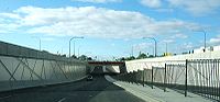
The current Labor state government has completed an underpass at Anzac Highway, and an overpass of the Adelaide-Glenelg Tram, in 2009 and 2010. The underpass model used is a diamond interchange. Further plans exist to construct a tunnel under Grange Road, Port Road and the Outer Harbor–Grange railway line to further reduce congestion.
In November 2005, the Royal Automobile Association (RAA) released their recommendations to the South Australian government in regards to the road network. South Road was found to be the poorest road in the state, registering a 2/10 on the RAA's scale. The recommendations given included $6 billion of funds to upgrade the roads of South Australia – with $1.5–2 billion to be spent on South Road alone. The RAA's plan for the road included a 6 km tunnel from Port Road all the way to the Anzac Highway underpass and over/underpasses at six other major intersections and two rail crossings. PDF
On 18 August 2007, the then Prime Minister John Howard announced that South Road was to be included in the AusLink National Road Network, and also pledged $1 billion in funding for the project between 2007 and 2020.[2]
In October 2009, both the Premier of South Australia and the Prime Minister of Australia released plans for the South Road Superway- a 3–4 km section of elevated freeway running from the Port River Expressway to the intersection of Regency Road at a cost of $800million. The project is expected to start in 2010 and be completed by 2014. The elevated part will avoid crossing Grand Junction, Cormack Roads, and the Port Adelaide-Dry Creek railway. Unfortunately, this will duplicate what is already one of the best parts of South road, (3 lanes each direction), while other parts remain in urgent need of an upgrade, (between Port and Regency roads, for example).
Major intersections (north–south)
South Road / Main South Road

Southbound Northbound Start South Road 
from Salisbury HighwayEnd South Road
continues as Salisbury Highway
to &
& 
no access. Port River Expressway 

PORT FLAT FREIGHT RAIL LINE
grade separation proposed [3]PORT FLAT FREIGHT RAIL LINE
grade separation proposed [3]Cormack Road 
grade separation proposed [3]Cormack Road
grade separation proposed [3]Grand Junction Road
National Eastbound
grade separation proposed [3]Grand Junction Road
State Westbound
grade separation proposed [3]Days Road Days Road Regency Road Regency Road Torrens Road Torrens Road OUTER HARBOR RAIL LINE
grade separation proposed [4]OUTER HARBOR RAIL LINE
grade separation proposed [4]Port Road 
grade separation proposed [4]Port Road
grade separation proposed [4]Manton Street
grade separation proposed [4]Grange Road
grade separation proposed [4]Henley Beach Road Henley Beach Road Sir Donald Bradman Drive 

Sir Donald Bradman Drive Richmond Road Richmond Road Anzac Highway 
Anzac Highway GLENELG TRAM LINE [5]GLENELG TRAM LINE [5]Cross Road/NOARLUNGA RAIL LINE 
Cross Road/NOARLUNGA RAIL LINE Daws Road Daws Road Ayliffes Road Ayliffes Road Shepherds Hill Road Shepherds Hill Road Sturt Road
grade separation proposed [6]Sturt Road
grade separation proposed [6]Flinders Drive
EastboundOnly Eastbound Access to FMC. Southern Expressway 
Southbound Entry Onlyno access. Flagstaff Road 
Marion Road Majors Road Majors Road Black Road Black Road Chandlers Hill Road Chandlers Hill Road Panalatinga Road Southern Expressway
Northbound Entry OnlyPimpala Road
EastboundSherriffs Road
WestboundBains Road
EastboundO'Sullivan Beach Road
WestboundWheatsheaf Road
EastboundFlaxmill Road
WestboundDoctors Road
EastboundBeach Road
Westboundno exit. Honeypot Road
WestboundPennys Hill Road
EastboundLocal Access Only. no access. Southern Expressway Victor Harbor Road Victor Harbor Road Start Route
Continues as Main South Road
to Cape JervisEnd Route
Continues as RouteGallery
-

Looking south from the Cross Road Overpass, Edwardstown.
-

South Road overpass at Cross Road / Emerson Station..
See also
References
- ^ Old Noarlunga
- ^ Media Releases
- ^ a b c d e f "Federal Labor announces Support for South Australia road projects". Australian Labor Party. 2007-11-09. Archived from the original on 2008-03-12. http://web.archive.org/web/20080312145837/http://www.alp.org.au/media/1107/mslootran090.php. Retrieved 2008-05-26.
- ^ a b c d e f "Port Road Upgrade". South Australian Department for Transport, Energy and Infrastructure. 2007-08-17. http://www.dtei.sa.gov.au/infrastructure/south_road_upgrade/content/anzac_highway.html. Retrieved 2008-05-26.[dead link]
- ^ a b "Glenelg Tram Overpass". South Australian Department for Transport, Energy and Infrastructure. 2008-06-19. http://www.dtei.sa.gov.au/infrastructure/south_road_upgrade/content/glenelg_tram_overpass. Retrieved 2009-03-28.
- ^ a b "BUDGET: Transport infrastructure investment". Premier & Ministers of South Australia. 2006-09-21. http://www.ministers.sa.gov.au/news.php?id=640. Retrieved 2009-03-28.
 Road Infrastructure in Adelaide
Freeways Adelaide–Crafers Highway · Port River Expressway · South Eastern Freeway · Southern Expressway · Northern Expressway · Northern Connector (proposed) · South Road Superway (proposed) · North-South Corridor (proposed)
Highways and major roads Anzac Highway · Gawler Bypass Road · Glen Osmond Road · Grand Junction Road · Main North Road · Main South Road · Mount Barker Road · North East Road · Port Wakefield Road · Portrush Road · Salisbury Highway · Sir Donald Bradman Drive · South RoadOther roads City Ring Route · Cross Road · Daws Road · Fullarton Road · Goodwood Road · Greenhill Road · Hampstead Road · Kensington Road · Kings Road · McIntyre Road · Magill Road · Marion Road · Montacute Road · Montague Road · Tapleys Hill Road · The Parade · Regency Road · Torrens Road · Victoria RoadCity streets Grote Street · King William Street · Morphett Street · North Terrace · Pulteney Street · Wakefield Street · West Terrace
State Route A13: Elizabeth Vale to Victor Harbor
via Salisbury, Regency Park, Mile End, Reynella and Mount CompassJohn Rice Avenue Single carriageway - 4 lanes Salisbury Highway Joint Between Port Wakefield Rd & South RdDual carriageway - 4 lanes South Road Joint Between Salisbury Hwy & Grand Junction RdSingle and Dual carriageway - 4 to 6 lanes Victor Harbor Road Dual carriageway - 4 lanes Categories:- Roads in Adelaide
- Freeways and highways in Adelaide
-


Wikimedia Foundation. 2010.