- North Shore Mountains
-
North Shore Mountains Range  A view of the North Shore Mountains as seen looking west from the Mount Seymour alpine area in March. The obvious sharp-pointed peak near the upper right is Crown Mountain
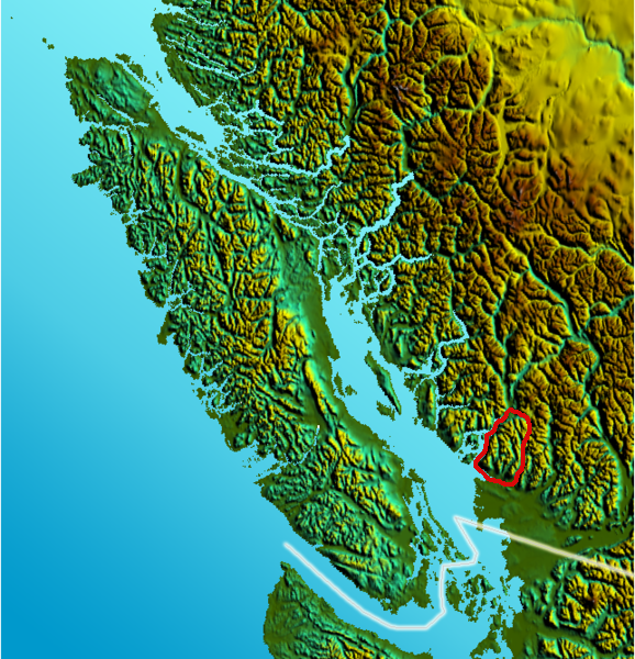
Country Canada Province British Columbia Part of Pacific Ranges Highest point Brunswick Mountain - elevation 1,788 m (5,866 ft) Area 939 km2 (363 sq mi) 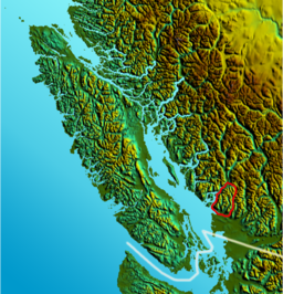 Location map of North Shore Mountains
The North Shore Mountains are a mountain range overlooking Vancouver in British Columbia, Canada. Their southernmost peaks are visible from most areas in Vancouver and form a distinctive backdrop for the city.
The steep southern slopes of the North Shore Mountains limit the extent to which the municipalities of Greater Vancouver's North Shore (West Vancouver, the District of North Vancouver, and the City of North Vancouver) can grow. In many places on the North Shore, residential neighbourhoods abruptly end and rugged forested slopes begin. These forested slopes are crisscrossed by a large network of trails including the Baden-Powell Trail, the Howe Sound Crest Trail, and a wide variety of mountain biking trails.
The North Shore Mountains are a small subrange of the Pacific Ranges, the southernmost grouping of the vast Coast Mountains. They are bounded on the south by Burrard Inlet, on the west and north-west by Howe Sound, and on the north and north-east by the Garibaldi Ranges. To the east the bounds are defined by Indian Arm (a branch of Burrard Inlet). The ridge running north from Mount Seymour has its own name, the Fannin Range, while the bulk of the range and most of the Howe Sound-flanking portion of it is officially known as the Britannia Range.
Although not particularly high, these mountains are rugged and should not be underestimated. Severe weather conditions in the North Shore Mountains often contrast dramatically with mild conditions in nearby Vancouver. This is especially true in winter, but even in summer large precipices are hidden very close to popular hiking trails and it is very easy to get lost, despite being in sight of the city. Those who venture into the North Shore Mountains for whatever reason should be well prepared at any time of year.
Three deep valleys divide the North Shore Mountains. These are, in order from west to east:
- Capilano River valley
- The Lynn Headwaters
- Seymour River valley
The Capilano and Seymour rivers emanate from the massive GVRD watershed area. The watershed extends deep into the North Shore Mountains region, but is strictly off-limits to all unauthorized human activities. The Lynn Headwaters, a deep cirque valley drained by Lynn Creek, is no longer part of the GVRD watershed and is now a very popular Regional Park.
There are two Provincial Parks in the area, Cypress Provincial Park and Mount Seymour Provincial Park. Both feature reliable road access, downhill ski areas, and extensive trail networks. Nearby Grouse Mountain features a downhill ski area and tourist attractions which are accessible by the Skyride, an aerial tramway. A very popular hiking trail, the Grouse Grind, climbs up the steep flanks of Grouse Mountain from the tramway parking lot. Before the Grouse Mountain Skyride was built, a chairlift operated from Skyline Drive at the head of North Vancouver's Lonsdale Avenue, and the ski area itself could be accessed via Mountain Highway, which now has a gate at its upper end in the Lynn Valley neighbourhood.
In the Seymour valley, a paved access road called the Seymour Trailway winds for many kilometres into the mountains. It is frequently used for recreation, and occasionally for TV and film productions such as Stargate SG-1.
Mountains
 A panorama view of the mountains
There are literally dozens of individual mountains in the North Shore group. The most familiar are:
Cypress Group
- Black Mountain (1217m) A forested summit overlooking Horseshoe Bay. Ski runs on the northern slopes are managed by the Cypress Mountain Resort.
- Hollyburn Mountain (1325m) A popular hiking destination. Commonly known as Hollyburn Ridge and the location of an old alpine recreation community dating back to the early years of the 20th Century. It is the site of the only groomed cross-country ski trails in the Lower Mainland.
- Mount Strachan (1454m) Ski runs on the southern slopes are managed by the Cypress Mountain Resort.
Grouse Area
- Mount Fromme (1185m) A large forested summit dome, often seen but seldom visited. This mountain is noted for the mountain biking trails on its south slopes.
- Grouse Mountain (1231m) Site of a very popular ski area, and the popular hiking trail Grouse Grind.
- Goat Mountain (1401m) Another popular alpine hiking destination, very conveniently located near the top of the Grouse Mountain aerial tramway.
- Crown Mountain (1504m) An exposed granite pyramid ringed by sheer cliffs.
Cathedral/Lynn Range
- Lynn Peak (1015m) A small forested mountain, nevertheless a popular hiking destination due to ease of access.
- The Needles (1258m) An isolated series of ridge-top summits north of Lynn Peak.
- Coliseum Mountain (1441m) A remote alpine area consisting of a series of gentle granite exposures.
- Mount Burwell (1541m) A remote granite dome located at the limit of legal backcountry access.
- Cathedral Mountain (1737m) Among the tallest and most prominent of the North Shore Mountains, but off-limits due to its location within the GVRD watershed.
Fannin Range
- Mount Seymour (1449m) Good trails and convenient access by road make Seymour a local classic hiking area. Downhill ski area in winter.
- Mount Elsay (1419m) A remote backcountry peak located beyond Seymour.
- Mount Bishop (1509m) A rarely climbed peak in the remote northern region of Mt. Seymour Provincial Park.
Lions Area
- The Lions (1654m) Probably the most famous peaks in the North Shore Mountains. These mountains, a pair of twin granite domes, are visually distinctive and can be seen from much of the Greater Vancouver area.
- Mount Harvey (1652m) An isolated alpine peak located near the Lions.
- Brunswick Mountain (1788m) The highest of the North Shore mountains, located north of Mount Harvey.
See also
- Fannin Range
- Mountains of British Columbia
- Mountain Ranges of British Columbia
- North Shore (Greater Vancouver)
External links
Municipalities of Metro Vancouver Population over 100,000 Population over 50,000 Population over 10,000 Population under 10,000 Unincorporated areas Categories:- Pacific Ranges
- North Vancouver (district municipality), British Columbia
- West Vancouver
- Geography of Vancouver
- Mountain biking venues in Canada


Wikimedia Foundation. 2010.