- Montfermeil
-
Montfermeil
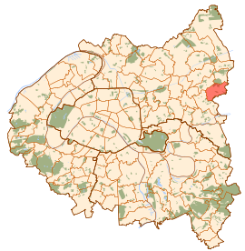
Paris and inner ring departments Location within Île-de-France region
 Montfermeil
Administration Country France Region Île-de-France Department Seine-Saint-Denis Arrondissement Le Raincy Canton Montfermeil Intercommunality Clichy-sous-Bois - Montfermeil Mayor Xavier Lemoine
(2008–2014)Statistics Elevation 116 m (381 ft) avg. Land area1 5.45 km2 (2.10 sq mi) Population2 26,060 (2006) - Density 4,782 /km2 (12,390 /sq mi) INSEE/Postal code 93047/ 93370 1 French Land Register data, which excludes lakes, ponds, glaciers > 1 km² (0.386 sq mi or 247 acres) and river estuaries. 2 Population without double counting: residents of multiple communes (e.g., students and military personnel) only counted once. Coordinates: 48°54′00″N 2°34′00″E / 48.9000°N 2.5667°E
Montfermeil is a commune in the eastern suburbs of Paris, France. It is located 17.2 km (10.7 mi) from the center of Paris.Montfermeil is famous as the location of Thénardier's inn in Les Misérables. It has made the headlines due to troubles in its social estate called "les Bosquets".
Contents
Heraldry
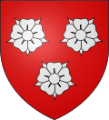
The arms of Montfermeil are blazoned :
Gules, 3 roses argent.Points of interest
- Parc Arboretum de Montfermeil
Transport
Montfermeil is served by two stations of the Paris Métro, RER, or suburban rail network. The closest stations are Villemomble-Le Raincy- Montfermeil and Gagny-Le Chénay.
Notable People From Montfermeil
- Abdoul Diakite footballer
- Larrys Mabiala footballer
- Kamulete Makiese footballer
- Kevynn Nyokas handball player
- Olivier Nyokas handball player
- Johnny Placide footballer
- Mamadou Samassa footballer
- Joel Sami footballer
See also
References
External links
- Official website (in French)
- pictures of Montfermeil housing project called "les bosquets" :[1]
Communes of the Seine-Saint-Denis department  Aubervilliers · Aulnay-sous-Bois · Bagnolet · Le Blanc-Mesnil · Bobigny · Bondy · Le Bourget · Clichy-sous-Bois · Coubron · La Courneuve · Drancy · Dugny · Épinay-sur-Seine · Gagny · Gournay-sur-Marne · L'Île-Saint-Denis · Les Lilas · Livry-Gargan · Montfermeil · Montreuil · Neuilly-Plaisance · Neuilly-sur-Marne · Noisy-le-Grand · Noisy-le-Sec · Pantin · Les Pavillons-sous-Bois · Pierrefitte-sur-Seine · Le Pré-Saint-Gervais · Le Raincy · Romainville · Rosny-sous-Bois · Saint-Denis · Saint-Ouen · Sevran · Stains · Tremblay-en-France · Vaujours · Villemomble · Villepinte · VilletaneuseCategories:
- Communes of Seine-Saint-Denis
- Île-de-France geography stubs


Wikimedia Foundation. 2010.