- Oreland (SEPTA station)
-
Oreland
SEPTA regional rail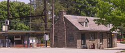
Oreland StationStation statistics Address Bridge Street & Pennsylvania Avenue
Oreland, PA 19075Coordinates 40°07′05″N 75°11′02″W / 40.1181°N 75.1839°WCoordinates: 40°07′05″N 75°11′02″W / 40.1181°N 75.1839°W Lines Lansdale/Doylestown LinePlatforms 2 side platforms Tracks 2 Other information Opened 1931 Owned by SEPTA Fare zone 3 Services Preceding station SEPTA Following station toward 30th Street StationLansdale/Doylestown Line toward DoylestownOreland is a station along the SEPTA Lansdale/Doylestown Line. The station, located at the intersection of Bridge Street and Bruce Road, includes a 99-space parking lot.
The station was built in 1931 by the Reading Railroad,[1] but has a more modern shelter across the tracks.
References
External links
Categories:- SEPTA Regional Rail stations
- Stations along Reading Company lines
- Pennsylvania railway station stubs
- SEPTA stubs

Wikimedia Foundation. 2010.