- Chicago Executive Airport
-
Chicago Executive Airport 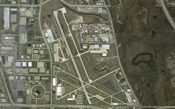
USGS aerial image IATA: PWK – ICAO: KPWK – FAA LID: PWK Summary Airport type Public Owner City of Prospect Heights and Village of Wheeling Serves Chicago Location Wheeling, Illinois Elevation AMSL 647 ft / 197 m Coordinates 42°06′51″N 087°54′06″W / 42.11417°N 87.90167°W Website Runways Direction Length Surface ft m 6/24 3,660 1,116 Asphalt 12/30 4,415 1,346 Asphalt 16/34 5,000 1,524 Asphalt Statistics (2008) Aircraft operations 108,429 Based aircraft 265 Source: FAA[1], airport website[2]  FAA diagram of Chicago Executive Airport
Chicago Executive Airport (IATA: PWK, ICAO: KPWK, FAA LID: PWK), formerly known as Palwaukee Municipal Airport, is a public airport located 18 nautical miles (33 km) northwest of Chicago, in the village of Wheeling in Cook County, Illinois, United States. This airport is publicly owned by the City of Prospect Heights and the Village of Wheeling.[1][2]
This airport logs over 167,000 take-offs and landings each year and is the third busiest airport in Illinois.[2]
Contents
History
The airport opened in 1925 as Gauthier's Flying Field. The airport was named Pal-Waukee in November 1928. That name was derived from its location near the intersection of Palatine Road and Milwaukee Avenue. In 1953, the airport was purchased by George J. Priester. He developed the airport over the next 33 years, installing paved runways, lighting, hangars and an air traffic control tower. In 1986, George's son Charlie negotiated the sale of the airport to Wheeling and Prospect Heights, at which time it was renamed Palwaukee Municipal Airport.[3][4][5]
Charlie Priester kept an FBO at the airport along with a charter company called Priester Aviation. Priester sold the FBO to Signature Flight Support in 2001, and turned over operational control of Priester Charter to his son Andy in 2004.
In August 2006, trustees from the village of Wheeling and alderman from the City Council of Prospect Heights voted to approve a name change. On October 17, 2006, Palwaukee Municipal Airport was officially renamed Chicago Executive Airport.
Facilities and aircraft
Chicago Executive Airport covers an area of 411 acres (166 ha) at an elevation of 647 feet (197 m) above mean sea level. It has three asphalt paved runways: 6/24 is 3,660 by 50 feet (1,116 x 15 m); 12/30 is 4,415 by 75 feet (1,346 x 23 m); 16/34 is 5,000 by 150 feet (1,524 x 46 m).[1]
For the 12-month period ending May 31, 2008, the airport had 108,429 aircraft operations, an average of 297 per day: 87% general aviation, 13% air taxi, and <1% military. At that time there were 265 aircraft based at this airport: 64% single-engine, 16% multi-engine, 19% jet and 1% helicopter.[1]
The airport can comfortably handle executive jet aircraft in the 20-seat range, such as the Grumman Gulfstream and the Bombardier Challenger. Larger aircraft occasionally visit the field. Occasional military transport aircraft, such as the Lockheed C-130, use the airport when transporting service members to local military facilities such as Great Lakes Naval Training Center or the North Chicago V.A. Hospital.
Major tenants of the airport include two national fixed base operators, Atlantic Aviation and Signature Flight Support, who provide fueling and handling for transient aircraft and a significant portion of the locally based aircraft. Priester Air Charter, Palwaukee Flyers, and several smaller firms and aircraft operators are also present.
In 2007 Chicago Executive's management created a public viewing area east of the south end of Runway 16-34 along Palatine Frontage Road. This area provides parking, a picnic table, bleacher seating and a PA speaker to allow visitors to monitor Air Traffic Control radio communications. A bulletin board provides a copy of the current FAA chart, posters for events and educational information. The area is open to the public 24/7.
Incidents
- October 30, 1996, a twin engine Gulfstream IV business jet with three crew members and one passenger lost control upon takeoff and crashed immediately to the north of the airport. All four aboard perished.[6]
- January 30, 2006, an eight-seat twin engine Cessna 421B with four passengers crashed about one mile (1.6 km) south of the airport. The aircraft was heading from Kansas to Palwaukee. There were no survivors.[7]
- January 5, 2010, a Learjet 35A crashed into the Des Plaines River in the Cook County Forest Preserve about a mile south of the airport while on final approach. The jet, operated by Royal Air Freight Inc. of Waterford, Michigan, was empty at the time of the crash. The pilot and co-pilot were killed.[8][9]
References
- ^ a b c d FAA Airport Master Record for PWK (Form 5010 PDF). Federal Aviation Administration. Effective 8 April 2010.
- ^ a b c Chicago Executive Airport, official website
- ^ Chicago Executive Airport: History (official website)
- ^ "Municipal airport experiences whirlwind on changes". Daily Herald. 2007-04-30. http://www.dailyherald.com/news/cookstory.asp?id=307605&cc=c&tc=whe&t=wheeling. Retrieved 2007-05-04.[dead link]
- ^ "Priester Aviation Making History by Looking Ahead". Aviation Business Journal. date unknown. Archived from the original on 2007-09-28. http://web.archive.org/web/20070928074606/http://www.priesterav.com/HTML/pop_press_9.htm. Retrieved 2007-05-04.
- ^ "Official NTSB accident report". http://ntsb.gov/ntsb/brief2.asp?ev_id=20001208X06863&ntsbno=CHI97MA017&akey=1.
- ^ "Official NTSB accident report". http://ntsb.gov/ntsb/brief2.asp?ev_id=20060203X00158&ntsbno=CHI06FA076&akey=1.
- ^ Simmons, Dan; Wronski, Richard; Wang, Andrew L. (January 6, 2010). "Bodies of pilot, co-pilot recovered from river". Chicago Tribune. http://www.chicagobreakingnews.com/2010/01/plane-reported-down-in-forest-preserve-near-wheeling-airport.html. Retrieved January 8, 2010.
- ^ "Preliminary NTSB accident report". http://www.ntsb.gov/ntsb/brief.asp?ev_id=20100105X11839&key=1.
Other sources
- "School's new home forces small airport to shut runway". The Chicago Tribune. 2007-04-19. http://www.chicagotribune.com/business/content/education/chi-0704180924apr19,0,4459935.story. Retrieved 2007-05-04.[dead link]
- "Pilots lobby to block plan to close suburban runway". The Chicago Tribune. 2007-04-25. http://www.chicagotribune.com/news/local/chicago/chi-0704240672apr25,1,6129277.story. Retrieved 2007-05-04.
External links
- Priester Aviation, charter flight services
- Signature Flight Support, fixed base operator (FBO)
- Atlantic Aviation, fixed base operator (FBO)
- Aerial photo as of 10 April 2002 from USGS The National Map
- FAA Airport Diagram (PDF), effective 20 October 2011
- FAA Terminal Procedures for PWK, effective 20 October 2011
- Resources for this airport:
- AirNav airport information for KPWK
- ASN accident history for PWK
- FlightAware airport information and live flight tracker
- NOAA/NWS latest weather observations
- SkyVector aeronautical chart, Terminal Procedures for KPWK
- OpenNav airspace and charts for KPWK
Categories:- Airports in Illinois
- Airports in the Chicago metropolitan area
- Buildings and structures in Cook County, Illinois


Wikimedia Foundation. 2010.