- Nakhon Si Thammarat Province
-
Nakhon Si Thammarat
นครศรีธรรมราช— Province — Phra Boromathat Chedi or Phra That Nakhon

SealMap of Thailand highlighting Nakhon Si Thammarat Province
Country  Thailand
Capital Nakhon Si Thammarat Government - Governor Thira Minthrasak (since October 2009) Area - Total 9,942.5 km2 (3,838.8 sq mi) Area rank Ranked 18th Population (2000) - Total 1,519,811 - Rank Ranked 5th - Density 152.9/km2 (395.9/sq mi) - Density rank Ranked 21st Time zone Thailand Standard Time (UTC+7) ISO 3166 code TH-80 Nakhon Si Thammarat (often in short Nakhon, Thai: นครศรีธรรมราช) is one of the southern provinces (changwat) of Thailand, at the eastern shore of the Gulf of Thailand. Neighboring provinces are (from south clockwise) Songkhla, Phatthalung, Trang, Krabi and Surat Thani.
The name of the province derives from its Pali-Sanskrit name Nagara Sri Dhammaraja (City of the Sacred Dharma King), which in Thai pronunciation becomes Nakhon Si Thammarat.
Contents
Geography
The province is located on the shore of the Gulf of Thailand on the east side of the Malay Peninsula. The terrain is mostly rugged hilly forest area. It contains the highest elevation of southern Thailand, the Khao Luang with 1,835 m, now protected in the Khao Luang national park.
 Nakhon Si Thammarat City Pillar Shrine
History
See also: Nakhon Si Thammarat kingdomThe area around Nakhon Si Thammarat was part (according to some scholars[who?] even the centre) of the Srivijaya kingdom from the 3rd century. The Ramkhamhaeng stele lists it among the areas within the realm of Sukhothai. After the fall of Sukhothai it fell it its successor, the Ayutthaya kingdom and was one of the tributary kingdoms or 1st class provinces.
With the thesaphiban administrative reforms the kingdom was more closely integrated into the Thai state and formed the Monthon Nakhon Si Thammarat. With the abolishment of the monthon system in 1932, the province covering only the central parts of the former kingdom became the top-level administrative subdivision of Thailand.
Symbols
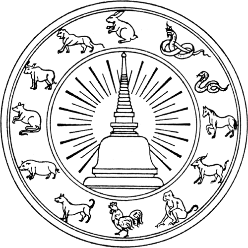
The provincial seal shows the Phra Baromathat Chedi of the Wat Phra Mahathat Voramahavihan, one of the most important historical sites in southern Thailand. According to the city chronicle it was already built in 311, but archaeology dates it to the 13th century. The chedi is surrounded by the animals of the Chinese zodiac in the seal. The twelve animals represent the twelve Naksat cities or city-states which were tributary to the Nakhon Si Thammarat kingdom: the mouse of Saiburi; the ox of Pattani; the tiger of Kelantan; the rabbit of Pahang (actually a city in Pahang which is said to be submerged by a lake now); a large snake of Kedah; a small snake of Phatthalung; a horse of Trang; a goat of Chumphon; a monkey of Bantaysamer (might be Chaiya, or a town in Krabi Province); a cock of Sa-ulau (unidentified city, might be Songkhla, Kanchanadit or Pla Tha); a dog of Takua Pa and a pig of Kraburi.
The provincial flower is the Golden Shower Tree (Cassia fistula), and the provincial tree is Millettia atropurpurea.
The provincial slogan is เมืองประวัติศาสตร์ พระธาตุทองคำ ชื่นฉ่ำธรรมชาติ แร่ธาตุอุดม เครื่องถมสามกษัตริย์ มากวัดมากศิลป์ ครบสิ้นกุ้งปู , which translates to A historical town, the golden Phra That, plentiful minerals, three-metal nielloware, numerous temples, abundant shellfish.
Administrative divisions
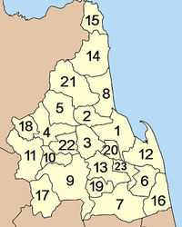
Nakhon Si Thammarat is subdivided into 23 districts (amphoe). The districts are further subdivided into 165 subdistricts (tambon) and 1428 villages (muban).
- Ron Phibun
- Sichon
- Khanom
- Hua Sai
- Bang Khan
- Tham Phannara
- Chulabhorn
- Phra Phrom
- Nopphitam
- Chang Klang
- Chaloem Phra Kiat
Tourism
Sights
Wat Phra Mahathat Woramahawihan (วัดพระมหาธาตุวรมหาวิหาร) This is a royal temple of the first class. Inside the temple are many buildings of importance, especially the royal building which has beautiful architecture from the Ayutthaya period and the Sam Chom building where the Buddha image attired in royal wardrobe Phra Si Thamma Sokarat is housed.
Phra Phutthasihing (พระพุทธสิหิงค์) This sacred image was believed to have been ordered by the king of Lanka in 157 AD and was brought to Thailand during the reign of King Ramkhamhaeng the Great. The hall housing the image was originally the Buddha image hall of the palace of Chao Phraya Nakhon (Noi).
Ho Phra Isuan (หอพระอิศวร) is a historical site of the Brahman religion. It has on display the Shiva Linga which is the symbol of Shiva, the Brahman god. There are also several bronze images such as the Siwa Nattarat image, Phra Uma and Phra Phikkhanet.
Ho Phra Narai (หอพระนารายณ์) is another Brahman place of worship opposite Ho Phra Isuan. A gray sandstone image of the god Narai wearing a hat and holding a conch in the right hand was discovered in the hall.
Phra Wihan Sung (พระวิหารสูง) The building houses plaster images with a fat clay core. The images are either from the 23rd-24th Buddhist century or from the late Ayutthaya period.
The Thai-style monks’ residence of Wat Wang Tawan Tok (กุฏิทรงไทยวัดวังตะวันตก) The 3 houses have a pointed roof connected to the other and there are exquisite Nakhon Si Thammarat designs on the walls, doors, windows, and vents. The Siam Architects Society named these houses the best conservation effort in the area of historical sites and temples in 1992.
Wat Chai Na Meditation Centre (สำนักวิปัสสนากรรมฐานวัดชายนา) Meditation courses are held for Thais and foreigners. The famous monk Phutthathat Bhikkhu established the centre as a branch of his monastery in Surat Thani.
Chinese buildings at Wat Pradu and Wat Chaeng (เก๋งจีนวัดประดู่และวัดแจ้ง) Built in the early Rattanakosin period, they house the ashes of Phraya Nakhon and believed to also have the ashes of King Taksin the Great.
Chedi Yak (เจดีย์ยักษ์) is the province’s second-tallest pagoda after Phra Borom That pagoda. It is said that the pagoda was built by Khotkhiri, a wealthy Mon, and his employees when they took refuge in the city in 1003.
Residence of Ok Ya Sena Phimuk (Yamada Nagamasa) (จวนออกญาเสนาภิมุข – ยามาดา นางามาซา) who was Japanese volunteer soldier living in the Ayutthaya period during the reign of King Songtham. He was rewarded for his many contributions to the palace by being appointed Ok Ya Sena Phimuk and as the lord of Nakhon Si Thammarat in 1629.
City wall (กำแพงเมือง) The wall runs parallel with the city moat from Chai Nuea Gate or Chai Sak Gate to the east for 100 metres.
Nakhon Si Thammarat National Museum (พิพิธภัณฑสถานแห่งชาติ นครศรีธรรมราช) The museum has on display artifacts found in 4 southern provinces, which are Nakhon Si Thammarat, Phatthalung, Surat Thani, and Chumphon. There is a good collection of rare books and important books sent by the National Library in Bangkok for locals to study.
Wirathai Monument (อนุสาวรีย์วีรไทย) is made of blackened copper. The locals call this monument Cha Dam or Chao Pho Dam. It was erected to honor Thai soldiers in southern Thailand who died fighting an invading Japanese force in World War II on December 8, 1941.
Arts and Culture Centre of Nakhon Si Thammarat Rajabhat Institute (สำนักศิลปและวัฒนธรรม สถาบันราชภัฏนครศรีธรรมราช) It is the centre of information on archaeological sites discovered in the province. The most important artifacts here are the stone inscriptions found at Khao Chong Khoi and artifacts from the ancient community at Wat Mok Lan.
Somdet Phra Sri Nakharin 84 Park (สวนสมเด็จพระศรีนครินทร์ 84) Originally part of Ratcharudi Park in the time of King Rama V, the park has an open zoo, a bird park, a health park, and a lake which is home to waterfowls that migrate here during January to March every year.
Bang Pu (บางปู) This is where quality pottery is made. Only bricks and flowerpots used to be made here but villagers from Ban Mok Lan have now set up stores selling their handicrafts in this area.Khao Luang National Park (อุทยานแห่งชาติเขาหลวง) The park has a winding mountain range, with the Khao Luang peak the highest of the peaks in southern Thailand at 1,835 metres above sea level. It is the watershed of more than 15 streams and rivers.
Karom waterfall (น้ำตกกะโรม) The waterfall originated in the Nakhon Si Thammarat mountain range and cascades down 19 levels with names like Nan Phung, Nan Nam Ruang, Nan Dat Fa, and Nan Soi Dao (the highest level at 1,300-1,400 metres). Kings and royal family members have visited this waterfall as evidenced by the initials of King Rama V and King Rama VI carved there.
Ban Khiri Wong (บ้านคีรีวง) is an ancient community which settled at the foot of Khao Luang in Tambon Kamlon, a path up the mountain. This peaceful village is like one big, happy family. The main occupation is growing mixed fruits, such as mangosteen, rambutan, durian, and Sato.
Khao Luang peak (ยอดเขาหลวง) features a trekking activity to enjoy nature on the Ban Khiri Wong-Khao Luang peak route.Mueang Nakhon Reception House (เรือนรับรองเมืองนคร) was built to receive His Majesty the King and H.R.H. Crown Princess Maha Chakri when they visited the city. It is located in an old fruit orchard of the Thongsamak family which built the house for the royal family on behalf of the city’s people.
Wat Khao Khun Phanom and the Khao Khun Phanom Scientific Study Centre (วัดเขาขุนพนมและศูนย์วิทยาศาสตร์เพื่อการศึกษาเขาขุนพนม) Wat Khao Khun Phanom is a temple of historical and archaeological importance. The temple has a cave lined with a brick wall and marked with heart-shaped stones marking the limits of the temple similar to those along the city wall.
Namtok Phrom Lok (น้ำตกพรหมโลก) This is a large waterfall with wide and lovely rock platforms. The source is in Nakhon Si Thammarat mountain range and flows down 4 levels, which are Nan Bo Nam Won, Nan Wang Mai Pak, Nan Wang Hua Bua, and Nan Wang Ai Le.
Namtok Ai Khiao (น้ำตกอ้ายเขียวหรือน้ำตกในเขียว) The source is also from Khao Luang. The surrounding area is still a dense jungle. The locals call the betel Phlu Pak Sai because of its hot flavor and sweet scent.
Ban Plai Uan (บ้านปลายอวน) in Mu 5, Tambon Phrom Lok is at the foot of Khao Luang near Phrom Lok waterfall. Most residents tend fruit orchards.
Namtok Krung Ching (น้ำตกกรุงชิง) Located in Tambon Krung Ching, the waterfall derived its name from Ton Ching which is a kind of palm prevalent in the area. The most breathtaking level is Nan Fon Saen Ha where water drops off a sheer cliff 100 metres high, splashing down creating a mist covering the area like rain unlike other falls.
Rafting on Khlong Klai (ล่องแก่งคลองกลาย) can be done on rubber boats provided by Krung Ching Administration Office in Mu 3, Tambon Krung Ching, near Krung Ching waterfall.
Tham Hong (ถ้ำหงส์) is a medium-sized cave with a stream running through its centre before going subterranean to another stream outside. The most distinctive characteristic of the cave is a waterfall that drops down 3 levels.
Namtok Yot Lueang or Namtok Mueang Mai (น้ำตกยอดเหลืองหรือน้ำตกเมืองใหม่) This medium-sized waterfall has 4 levels, which are Nan Toei, Nan Kradot, Nan Ya Kha, and Nan Plio.Namtok Tha Phae (น้ำตกท่าแพ) This beautiful ten-level waterfall has 3 levels which are accessible to the public; Nan Phae Noi, Nan Nang Khruan and Nan Toei.
Namtok Suan Ai (น้ำตกสวนอาย) is in Mu 5, Tambon Khlong La-ai, Amphoe Chawang.
Waterfall Suan Khan (น้ำตกสวนขัน) Three levels of the waterfall can be accessed.
Wat Tham Thong Phannara (วัดถ้ำทองพรรณรา) It became tradition that on the first full-moon night of the 11th lunar month (October) people would pay homage to the reclining image and the images representing the nuns called Phra Pring and Phra Prang.
Walailak University (มหาวิทยาลัยวลัยลักษณ์) This state university is one of the newest and most complete in the country, incorporating a university city and an education park.
Khao Nan National Park (อุทยานแห่งชาติเขานัน) The main topography is a high mountain range extending from Khao Luang National Park. The main peaks are Khao Nan Yai, Khao Nom and Sunyen. The park itself is a watershed of many waterways. The park’s main attraction is Sunantha.
Ban Nai Thung Handicrafts (หัตถกรรมบ้านในถุ้ง) is a Muslim Thai village near the sea. Aside from fishing, villagers use their spare time to make colored cloth kites in the shape of birds as well as birdcages for sale on both sides of the road.
Wat Mokhlan Archaeological Site (วัดโมคลาน) Items that can be seen here include traces of stone pillars, carvings around doorways, religious stones, an ancient pond, and statue bases. The Fine Arts Department declared this area an archaeological site in 1975.
Pottery Village (หมู่บ้านปั้นหม้อ) The village still adheres to the old technique of making pottery by hand. The pots made here are large and thick and have little design.Hat Sichon (หาดสิชล), or Hua Hin Sichon as known to locals, is a well-known destination of the district. Rocks line the beach all the way to a curved sandy stretch where people can swim.
Hin Ngam Beach (หาดหินงาม) has a unique characteristic in that it is littered with round rocks of various striking colors.
Kho Khao Beach (Piti Beach) (หาดคอเขาหรือหาดปิติ) is a popular beach that connects to Hin Ngam beach.
Si Khit Waterfall (น้ำตกสี่ขีด) This small waterfall originates in the mountains to the west and flows down several levels amidst pristine natural surroundings.
Khao Kha Archaeological Site (แหล่งโบราณคดีเขาคา) Khao Kha is a sacred religious place of the Saiwanikai sect which worships Shiva as its highest god. Many artifacts used in rites have been found here including phallic symbols, holy water pipes, ruins, and an ancient pond.Hat Khanom - Mu Ko Thale Tai National Park (อุทยานแห่งชาติหาดขนอม-หมู่เกาะทะเลใต้) The park incorporates islands, mountains and coastal areas of Amphoe Khanom and some parts of Surat Thani.
Ao Khanom (อ่าวขนอม) is the largest bay in Khanom. Khanom beach is a long beach that connects to other beaches, as follows:
Hat Nai Phlao(หาดในเพลา) is Khanom’s largest. The overall scenery is one that features perfect nature, including a clean, white beach conducive to a day in the sun.
Hat Na Dan (หาดหน้าด่าน) is a long, palm-fringed white beach. From this quiet beach, one can see the beautiful aquamarine water of the Gulf of Thailand.
Hat Nai Praet (หาดในแปร็ด) is a beautiful, long curved beach. This beach is between Hat Na Dan and Hat Nai Phlao and is rocky in some areas.
Ao Thong Yi (อ่าวท้องหยี) Ao Thong Yi is encompassed by Khao Phlao and Khao Klang, making it peaceful and removed from the outside world.
Tham Khao Wang Thong (ถ้ำเขาวังทอง) The cave has many large and small chambers, each with stalagmites and stalactites of odd sizes and shapes, like pagodas, dinosaurs, custard apples, and fried eggs.
Khao Phlai Dam (เขาพลายดำ) is a seaside mountain which borders Khanom and Sichon. The Khao Phlai Dam Wildlife Development and Conservation Office are here in Tambon Thung Sai.
Wat Kradangnga (วัดกระดังงา) is an ancient temple of Khanom that was probably built during the Ayutthaya period. Inside the convocation hall are exquisite murals of Lord Buddha’s life. There is also a magnificent Buddha image from the Ayutthaya period and interesting artifacts, particularly plates and bowls.
Wat That Tharam or Wat Khao That (วัดธาตุธารามหรือวัดเขาธาตุ) is unique in that it has a pagoda made of coral located on Khao That. The entire pagoda is made of coral in the shape of an inverted jar. The pagoda is surrounded by Buddha images of red sandstone.
Wat Chedi Luang (วัดเจดีย์หลวง) This ancient community still shows numerous traces of mounds, ponds, stones from a sanctuary, statue bases, and phallic symbols.
Museum Honouring the King for the Development of Pak Phanang Basin (พิพิธภัณฑ์เฉลิมพระเกียรติเพื่อพัฒนาพื้นที่ลุ่มน้ำปากพนัง) is a museum conceived by the Project to Develop Pak Phanang Basin of His Majesty the King that covers Nakhon Si Thammarat, Phatthalung and Songkhla.
Pak Phanang Coast and Talumphuk Cape (ชายทะเลปากพนังและแหลมตะลุมพุก) are the sites of a severe storm in Nakhon Si Thammarat in 1962. The coast of Pak Phanang is a long beach with the Talumphuk cape to the north jutting out into the Gulf of Thailand like a crescent moon.
Ban Rang Nok (บ้านรังนก) is famous for the nests made by swallows in the town. Several houses and buildings have been closed because of the immense number of swallows inhabiting them.
Wat Nantharam (วัดนันทาราม) used to be called Wat Tai and currently houses Luang Pho Phut, a red sandstone Buddha image from the Ayutthaya period. In addition, the temple houses a giant phallic symbol found at Khao Kha archaeological site and is believed to be around 1,200 years old and from the 12th-14th Buddhist century.Khao Chong Khoi Stone Inscription (ศิลาจารึกเขาช่องคอย) This is the oldest Sanskrit stone inscription found in southern Thailand and dates from the 11th-12th Buddhist century. It tells the story of people asking for shelter from Shiva and jungle spirits.
Fan Making Village (หมู่บ้านทำพัดใบกะพ้อ) The villagers here use their spare time to make Kapho fans for sale nationwide.Namtok Yong National Park (อุทยานแห่งชาติน้ำตกโยง) or locally known as Yong Sai Yai waterfall has a total area of 49,403.25 acres (199.9279 km2). The park’s pristine nature includes the Yong waterfall where streams converge into one giant rope-like waterfall dropping from a high cliff to the large pool below.
Tham Talot (ถ้ำตลอด) The cave can be traversed from one exit to the other. Hence, its name of Talot cave. Inside is a huge reclining Buddha image stretching the length of the cave. This sacred image is decorated with murals of Lord Buddha’s life drawn by Mr. Naep Thichinnaphong, a famous artist of Nakhon Si Thammarat.
Kuan Im Goddess Image (พระโพธิสัตว์กวนอิม) is a large white plaster image. The image is situated in the middle of a large pond surrounded by fountains.Namtok Khlong Chang and Trekking on Khao Men (น้ำคลองจังและเดินป่าเขาเหมน) are must things to see and do in this district. The Khlong Chang waterfall has 7 tiers and is one of southern Thailand’s most beautiful.
Local Products
Nielloware (เครื่องถมนคร) is a famous craft of the province and is well known since the old days. There are two types; black surface with white designs and black surface with gold designs. The Nakhon Si Thammarat College of Arts and Handicrafts teaches this craft. Nielloware of this province is popular for its durability and intricate designs by hand. The finished product is a bright, shiny black object with beautiful patterns.
Brassware (เครื่องทองเหลือง)
Necklaces (สร้อยนะโม สร้อยเงิน สร้อยสามกษัตริย์) have long been the work of local silversmiths who can create gold, silver and mixed (gold, silver and an alloy) necklaces.
Shadow play making (การแกะหนังตลุง) is an art that goes with the popular southern entertainment of shadow play. Thai shadow play figures have been transformed from those found in Java so that they are now very Thai. The hands and feet of the figures are fully movable during performances. The hide used can be either raw cow or goat hide.
Yan Liphao basketry (จักสานย่านลิเภา) is another famous product of the South, particularly in Nakhon Si Thammarat where people have been making it for over 100 years. Yan Liphao is a climbing plant that grows in damp places. It likes to exist among other plants. The trunk is very tough and durable, so locals found a way to make good use of it by making household goods such as handbags, tobacco boxes, tea utensils, etc.Kapho fans (พัดใบกระพ้อ) are made from a kind of palm called Ton Pho by locals. The leaves are dried and then woven into fans. Some are dyed into bright colors and sold at reasonable prices. Kapho fans are well known and sold throughout the country.
Culture
Festivals
Hae Pha Khuen That Festival (ประเพณีแห่ผ้าขึ้นธาตุ) is celebrated at Phra Borom That Chedi. The pagoda is considered to be the representative of Lord Buddha and is believed by locals to possess unsurpassed might of righteousness as it contains holy relics. Every year Buddhists pay homage to the pagoda by organizing a procession bearing a religious cloth to wrap around the pagoda to bring good fortune and success. This festival is held twice a year during Makha Bucha Day (the 15th full-moon night of February) and Wisakha Bucha Day (the 15th full-moon night of May).
Festival of the Tenth Lunar Month (ประเพณีเทศกาลเดือนสิบ) is a grand event of the province and of southern Thailand. This festival is held from the 1st waning-moon night to the 15th waning-moon night every September. It is held to pay respect to deceased ancestors. According to Buddhism beliefs, the dead had many sins and were sent to hell to become a demon. The demons are allowed to come up to meet their relatives for 15 days in September, but must return to hell before sunrise of the 15th day. The living tries to appease the spirits by taking food to temples to make merit. Beginning on the 13th day, people will go shopping for food to be given. The 14th day is spent preparing and decorating the food tray, and the 15th day is the actual merit-making day. The tray presented nowadays has elaborate designs but still retains traditional components. Contests to find the most beautiful tray are held. A magnificent procession proceeds along Ratchadamnoen Road on the 14th day.
Chak Phra or Lak Phra Festival (ประเพณีชักพระหรือลากพระ) is influenced by Indian culture, which expanded into the province a long time ago. The festival signifies the joy that people had when Lord Buddha returned from a star and the Lord was invited to sit on a throne and carried to a palace. In practice, locals would bear a Buddha image holding a bowl in a procession around the city. This is a great way for escape from daily routine and it is a fun competition to find who is the most religious. Held in October, the festival is preceded by activities 7 days before, such as beating drums, playing castanets and decorating the ceremonial throne for the image. The actual ceremony is usually held only on the last day of the Buddhist lent. People would take the image from the temple in the morning and proceed to Benchama Rachuthit School in Amphoe Mueang. This is also done in front of Ron Phibun district office. In addition, there is a water-borne procession on Pak Phanang River in Pak Phanang, which coincides with an annual boat race for a trophy from the Crown Princess.
Cow fighting (กีฬาชนวัว) is an identity of southern Thailand and is an ancient sport of Nakhon Si Thammarat. Many details are involved in staging a contest. Cows selected will have the best breeding and will be trained and carefully looked after. The contest itself is held weekly with districts not far from the city taking turn to host, which are Mueang, Pak Phanang, Chawang, Thung Song, Hua Sai, and Ron Phibun.External links
- Province page from the Tourist Authority of Thailand
- Website of province (Thai)
- Nakhon Si Thammarat provincial map, coat of arms and postal stamp
- Information and interactive map for tourists and residents
- Kha Nan National Park species

Surat Thani Province Krabi Province 
Gulf of Thailand  Nakhon Si Thammarat Province

Trang Province Phattalung Province Songkhla Province Provinces of Thailand Capital: Bangkok North North-East Amnat Charoen · Bueng Kan · Buri Ram · Chaiyaphum · Kalasin · Khon Kaen · Loei · Maha Sarakham · Mukdahan · Nakhon Phanom · Nakhon Ratchasima · Nong Bua Lamphu · Nong Khai · Roi Et · Sakon Nakhon · Sisaket · Surin · Ubon Ratchathani · Udon Thani · YasothonCentral Ang Thong · Chai Nat · Kamphaeng Phet · Lop Buri · Nakhon Nayok · Nakhon Pathom · Nakhon Sawan · Nonthaburi · Pathum Thani · Phetchabun · Phichit · Phitsanulok · Phra Nakhon Si Ayutthaya · Samut Prakan · Samut Sakhon · Samut Songkhram · Saraburi · Sing Buri · Sukhothai · Suphan Buri · Uthai ThaniEast West South Chumphon · Krabi · Nakhon Si Thammarat · Narathiwat · Pattani · Phang Nga · Phatthalung · Phuket · Ranong · Satun · Songkhla · Surat Thani · Trang · Yala


Wikimedia Foundation. 2010.