- New Jersey Route 87
-
Route 87
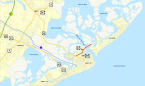
Highways in the Atlantic City area with NJ 87 in red.Route information Maintained by SJTA Length: 1.70 mi[1] (2.74 km) Existed: 1953 – present Major junctions South end:  US 30 in Atlantic City
 Route 187 in Atlantic City
 ACE Conn. in Atlantic City
North end:  CR 638 in Brigantine
Highway system New Jersey State Highway Routes
Interstate and US←  Route 85
Route 88  →
→←  CR 637
CR 640  →
→Route 87 is a state highway located in Atlantic County in the U.S. state of New Jersey. It runs 1.70 mi (2.74 km), heading north from Atlantic City at an intersection with U.S. Route 30 (Absecon Boulevard) to Brigantine, where it terminates at the end of the Brigantine Bridge over the Absecon Channel, continuing as County Route 638 (Brigantine Boulevard). In Atlantic City, the route runs through the Marina District, which contains a few casinos, along Huron Avenue and Brigantine Boulevard. Here, Route 87 intersects with Route 187 (Brigantine Boulevard) and the Atlantic City-Brigantine Connector, the latter providing a limited-access route between Route 87 and the Atlantic City Expressway. Route 87 is the only road to and from Brigantine.
What is now Route 87 was initially proposed as Route S4A in 1927, a spur from Route 4 (now U.S. Route 9) in Tuckerton, Ocean County, south through Brigantine to Atlantic City. The portion of this route south of Little Beach was to be built by Atlantic County; however, the state took over plans of building the road in 1938. Despite this, Route S4A was never completed between Brigantine and Little Beach, and the portion of the road that existed in Ocean County was removed from the state highway system by 1941. In 1945, Route S56, a spur of Route 56 (now U.S. Route 30), was proposed to run from Atlantic City to Brigantine along Brigantine Boulevard. Route 87 was created on its current alignment in 1953 as an unsigned route, replacing Route S4A and the proposed Route S56. Previously, Route 87 split into two alignments in Atlantic City along Huron Avenue and Brigantine Boulevard; the Brigantine Boulevard alignment eventually became Route 187.
Contents
Route description
 Route 87 southbound approaching intersection with Route 187.
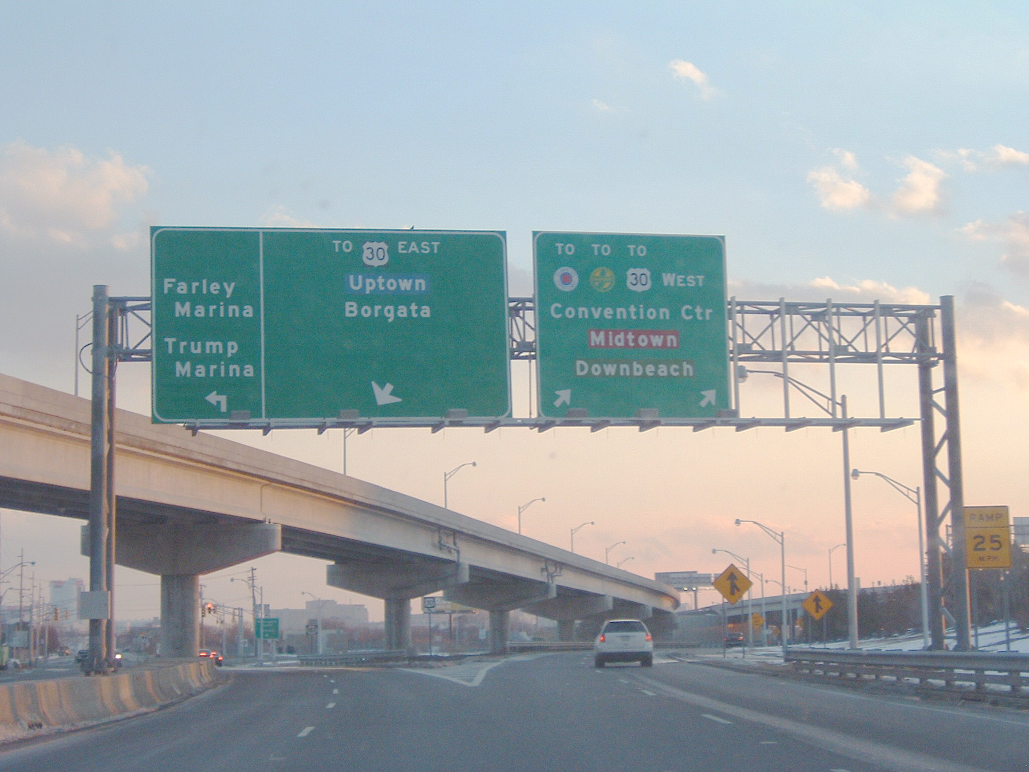
Route 87 begins at an intersection with U.S. Route 30 in Atlantic City, heading to the northeast on Huron Avenue, an undivided road with two northbound lanes and three southbound lanes. Immediately after beginning, it passes under the Atlantic City – Brigantine Connector and comes to a ramp that provides access from southbound Route 87 to the southbound connector.[1][2] From here, the route widens to seven lanes, with two northbound lanes and five southbound lanes. It passes by the Borgata casino, with a ramp from the casino to the northbound direction.[2] The road becomes a four-lane divided highway and passes under a ramp from the Atlantic City – Brigantine Connector to the Borgata before heading under northbound direction of the connector.[1][2] Here, a ramp from the connector provides access to Route 87.[2] A short distance later, the route comes to the northern terminus of Route 187 and turns north to follow Brigantine Boulevard, which is a four-lane divided highway.[1]
The route passes to the west of the Golden Nugget casino and comes to a ramp that provides access from northbound Route 87 to both the Trump Marina and Harrah's Atlantic City casinos before passing under the northbound Atlantic City – Brigantine Connector again. Immediately after, the route has a ramp from the southbound direction that provides access to the connector and westbound U.S. Route 30. The northbound Atlantic City – Brigantine Connector parallels Route 87 to the east as it turns northeast and comes to a right-in/right-out in the southbound direction that serves both Harrah's and Borgata.[2] From here, the route passes to the southeast of Harrah's.[1][2] The northbound Atlantic City – Brigantine Connector merges onto northbound Route 87 before the route comes to a ramp that provides access to the northbound direction of the route from Harrah's.[2] Past here, the route crosses over the Absecon Channel on a bridge and runs along the border of Atlantic City to the northwest and Brigantine to the southeast.[1] After crossing the Absecon Channel, the route arrives on Brigantine Island and passes through wetlands, with U-turn ramps in both directions. A short distance later, Route 87 ends and County Route 638 continues along Brigantine Boulevard through Brigantine.[1][2]
History
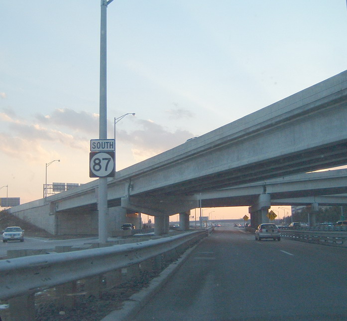
 Signage for Route 87 southbound past Route 187.
 Route S4A (1927-1953)
 Route S56 (1945-1953)
In 1927, a spur of Route 4, Route S4A, was proposed as a route running from Route 4 (now U.S. Route 9) in Tuckerton in Ocean County south to Little Beach.[3][4] In 1929, this route was to continue south through Brigantine to Atlantic City, with the portion south of Little Beach to be built by Atlantic County.[5] The state of New Jersey took over the proposed extension of Route S4A from Little Beach to Atlantic City in 1938.[6] However, the portion of this route between Brigantine and the Atlantic/Ocean County line was never built, and the portion of road that existed in Ocean County was removed from the state highway system by 1941.[7] In 1945, another route called Route S56, a spur of Route 56 (now U.S. Route 30), was proposed to run north along Brigantine Boulevard (present-day Route 187 and Route 87) from Atlantic City to Brigantine.[8] In the 1953 New Jersey state highway renumbering, Route 87 was designated as an unsigned route along the former alignment of Route S4A and the proposed Route S56 between U.S. Route 30 in Atlantic City and Brigantine.[9][10] Following the 1953 renumbering, the southern portion of Route 87 in Atlantic City split into two alignments, with one following Huron Avenue and the other following Brigantine Boulevard.[11] Eventually, the alignment of Route 87 along Brigantine Boulevard between U.S. Route 30 and Huron Avenue became Route 187.[12] In 2001, the Atlantic City – Brigantine Connector was completed, linking Route 87, the casinos in the Marina District, and Brigantine with the Atlantic City Expressway.[13]
Exit list
The entire route is in Atlantic County.
Location Mile[1] Destinations Notes Atlantic City 0.00 US 30 (Absecon Boulevard)Traffic signal; southern terminus 0.13 
 To AC Exwy. to G.S. Pkwy. – Convention Center, Midtown, Downbeach
Atlantic City – Brigantine Connector; southbound exit only 0.46 Renaissance Pointe, Borgata, The Water Club 0.57 US 30 east – Uptown, BorgataNJ 187 south (Brigantine Boulevard); traffic signal; signed southbound only Farley Marina, Trump Marina Huron Avenue; traffic signal; signed southbound only 0.66 Trump Marina, Harrah's Northbound only 0.84 Harrah's, Borgata Southbound only 0.94 Harrah's Northbound only; access only from Atlantic City – Brigantine Connector on-ramp 1.42 Bridge across Absecon Channel Brigantine 1.70 CR 638 north (Brigantine Boulevard)Northern terminus 1.000 mi = 1.609 km; 1.000 km = 0.621 mi See also
 U.S. Roads portal
 New Jersey portal
References
- ^ a b c d e f g h "Route 87 straight line diagram" (PDF). New Jersey Department of Transportation. http://www.state.nj.us/transportation/refdata/sldiag/00000087__-.pdf. Retrieved 2009-08-04.
- ^ a b c d e f g h Google, Inc. Google Maps – overview of New Jersey Route 87 (Map). Cartography by Google, Inc. http://maps.google.com/maps?f=d&source=s_d&saddr=absecon+boulevard+and+huron+avenue+atlantic+city,+nj&daddr=route+87+%40+39.3883,+-74.415&geocode=%3BFYwEWQIdaISQ-w&hl=en&mra=ls&sll=39.380986,-74.427248&sspn=0.027466,0.055017&ie=UTF8&ll=39.381217,-74.427481&spn=0.027466,0.055017&t=h&z=14. Retrieved 2009-08-04.
- ^ State of New Jersey, Laws of 1927, Chapter 319.
- ^ Williams, Jimmy and Sharon. "1927 New Jersey Road Map". 1920s New Jersey Highways. http://www.jimmyandsharonwilliams.com/njroads/1920s/images/1927_routes.gif. Retrieved 2008-10-08.
- ^ State of New Jersey, Laws of 1929, Chapter 126, Page 215, Section 4.
- ^ State of New Jersey, Laws of 1938, Chapter 341, Page 852, Section 1.
- ^ Mid-West Map Co. (1941). Map of Pennsylvania and New Jersey (Map). Cartography by H.M. Gousha. http://www.mapsofpa.com/roadcart/1941_1467m.jpg. Retrieved 2009-03-29.
- ^ State of New Jersey, Laws of 1945, Chapter 1, Page 11, Section 1.
- ^ 1953 renumbering. New Jersey Department of Highways. http://en.wikisource.org/wiki/1953_New_Jersey_state_highway_renumbering. Retrieved July 31, 2009.
- ^ "New Road Signs Ready in New Jersey". The New York Times. December 16, 1952. http://img123.imageshack.us/img123/6933/19521216newroadsignsreaiu6.jpg. Retrieved 2009-07-20.
- ^ Chevron Oil Company (1969). Map of New Jersey (Map). Cartography by H.M. Gousha.
- ^ Rand McNally (1996). United States-Canada-Mexico Road Atlas (Map).
- ^ "Travel Advisory; Marina District Tunnel Is Open in Atlantic City". The New York Times. August 26, 2001. http://www.nytimes.com/2001/08/26/travel/travel-advisory-marina-district-tunnel-is-open-in-atlantic-city.html?scp=1&sq=atlantic+city+brigantine+connector&st=nyt. Retrieved 2009-04-05.
External links
Categories:- State highways in New Jersey
- Transportation in Atlantic County, New Jersey


Wikimedia Foundation. 2010.