- Cabot Trail
-
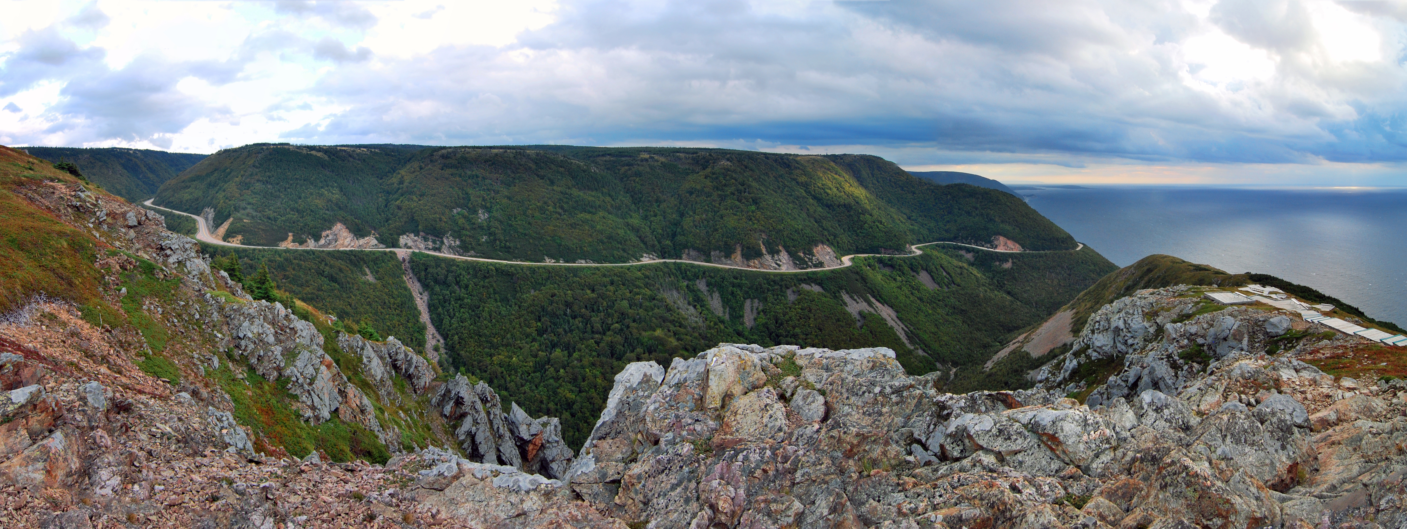
 The Cabot Trail viewed from the Skyline Hiking Trail
The Cabot Trail is a highway and scenic roadway in the Canadian province of Nova Scotia.
It is located in northern Victoria County and Inverness County on Cape Breton Island.
The route measures 298 km (185 mi) in length and completes a loop around the northern tip of the island, passing along and through the scenic Cape Breton Highlands. It is named after the explorer John Cabot who landed in Atlantic Canada in 1497, although most historians agree his landfall likely took place in Newfoundland and not Cape Breton Island. Construction of the initial route was completed in 1932.
The northern section of the Cabot Trail passes through Cape Breton Highlands National Park. The western and eastern sections follow the rugged coastline, providing spectacular views of the ocean. The southwestern section passes through the Margaree River valley before passing along Bras d'Or Lake.
 View of the commercial and residential establishments that exist at Pleasant Bay, along the Cabot Trail's northern-most segment
The Cabot Trail is the only trunk secondary highway in Nova Scotia which does not have a signed route designation. Road signs along the route instead have a unique mountain logo.
The road is internally referred to by the Department of Transportation and Public Works as Trunk 30. The Trunk 30 road named the "Cabot Trail" loops from Exit 7 on Nova Scotia Highway 105 at Buckwheat Corner to Exit 11 on Highway 105 at South Haven. The scenic travelway known as the "Cabot Trail" includes all of Trunk 30, as well as the portion of Highway 105 between exits 7 and 11.
The entire route is open year-round.
Communities
 Sunrise Valley, Cape North in 2010
- Baddeck, the gateway to the Cabot Trail and the location of the Alexander Graham Bell National Historic Site
- St. Ann's, home of the world famous Gaelic College of Celtic Arts and Crafts
- Ingonish, a fishing village and one of the first areas settled on Cape Breton and home to the Keltic Lodge resort, it is the eastern entrance to Cape Breton Highlands National Park
- Belle Cote, a small picturesque fishing village located at the mouth of the Margaree River where it flows into the Gulf of St Lawrence, marks the traditional boundary of the Scottish settlements to the south and the Acadian villages to the north that are located on the western side of Cape Breton Island.
- Chéticamp, an Acadian fishing village famous for its hooked rugs and fiddle music, it is the western entrance to Cape Breton Highlands National Park
- Dingwall, Nova Scotia, a small fishing village located in the highlands of Cape Breton Island
- Cape North, Nova Scotia, the northernmost point of the Cabot Trail and home of the North Highlands Community Museum.
See also
External links
- Cabot Trail official website
- Cabot Trail on Nova Scotia Tourism website
- Hike the Highlands Festival
- Cape Breton Highlands National Park
Roads and highways in Nova Scotia 100-series Trunk Routes Collector roads 201 · 202 · 203 · 204 · 205 · 206 · 207 · 208 · 209 · 210 · 211 · 212 · 213 · 214 · 215 · 216 · 217 · 219 · 221 · 223 · 224 · 236 · 239 · 242 · 245 · 246 · 247 · 252 · 253 · 255 · 256 · 276 · 277 · 289 · 301 · 302 · 303 · 304 · 305 · 306 · 307 · 308 · 309 · 311 · 312 · 316 · 318 · 320 · 321 · 322 · 324 · 325 · 326 · 327 · 328 · 329 · 330 · 331 · 332 · 333 · 334 · 335 · 336 · 337 · 340 · 341 · 344 · 347 · 348 · 349 · 354 · 357 · 358 · 359 · 360 · 362 · 366 · 368 · 374 · 376 · 395Scenic routes Cabot Trail · Ceilidh Trail · Bras d'Or Lakes Scenic Drive · Evangeline Trail · Fleur-de-lis Trail · Fundy Shore Ecotour · Glooscap Trail · Lighthouse Route · Marconi Trail · Marine Drive · Sunrise TrailCoordinates: 46°29′13″N 60°44′46″W / 46.48694°N 60.74611°W
Categories:- Nova Scotia provincial highways
- Scenic travelways in Nova Scotia
- Roads in Victoria County, Nova Scotia
- Roads in Inverness County, Nova Scotia
- Historic trails and roads in Canada


Wikimedia Foundation. 2010.