- Northwest Territory
-
This article is about the historical U.S. territory. For the Canadian territory, see Northwest Territories. For the Hudson's Bay Company territory, see North-Western Territory. For the northwestern corner of the Lower 48, see Northwestern United States. For other related terms, see Northwest (disambiguation).
Territory Northwest of the River Ohio Organized incorporated territory of the United States ← 
1787–1803  →
→
 →
→
 →
→
Flag
Government Organized incorporated territory Governor - 1787-1802 Arthur St. Clair - 1803 Charles Willing Byrd History - Northwest Ordinance July 13 1787 - Affirmed by Congress August 7, 1789 - Indiana Territory created May 7, 1800 - Statehood of Ohio March 1 1803 The Territory Northwest of the River Ohio, more commonly known as the Northwest Territory, was an organized incorporated territory of the United States that existed from July 13, 1787, until March 1, 1803, when the southeastern portion of the territory was admitted to the Union as the state of Ohio. Previously, it was part of the Indian Reserve, a territory under British rule set aside in the Royal Proclamation of 1763 for use by American Indians, which was assigned to the United States in the Treaty of Paris (1783).
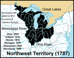
The Congress of the Confederation enacted the Northwest Ordinance in 1787 to provide for the administration of the territories and set rules for admission as a state. On August 7, 1789, the new U.S. Congress affirmed the Ordinance with slight modifications under the Constitution. The territory included all the land of the United States west of Pennsylvania and northwest of the Ohio River. It covered all of the modern states of Ohio, Indiana, Illinois, Michigan, and Wisconsin, as well as the northeastern part of Minnesota. The area covered more than 260,000 square miles (670,000 km2).
Contents
History
European exploration of the region began with French-Canadian voyageurs in the 17th century, followed by French missionaries and French fur traders. French-Canadian explorer Jean Nicolet was the first recorded white entrant into the region, landing in 1634 at the current site of Green Bay, Wisconsin (although Étienne Brûlé is stated by some sources as having explored Lake Superior and possibly inland Wisconsin in 1622). The French exercised control from widely separate posts in the region they claimed as New France, the oldest of which is Detroit, founded in 1701. France ceded the territory to the Kingdom of Great Britain in the Treaty of Paris, which ended the French and Indian War.
A new colony, named Charlotina, was proposed for the southern Great Lakes region. However, facing armed opposition by Native Americans, the British issued the Proclamation of 1763, which prohibited white settlement west of the Appalachian Mountains. This action angered American colonists interested in expansion as well as those who had already settled in the area. In 1774, by the Quebec Act, the region was annexed to the Province of Quebec in order to provide a civil government and to centralize British administration of the Montreal-based fur trade. The prohibition of settlement west of the Appalachians remained and this was a contributing factor to the American Revolution.
In February 1779, George Rogers Clark of the Virginia Militia captured Vincennes from British commander Henry Hamilton. Virginia capitalized on Clark's success by laying claim to the whole of the Old Northwest, calling it Illinois County, Virginia,[1] until 1784, when Virginia ceded its land claims to the federal government.
The Old Northwest Territory included all the then-owned land of the United States west of Pennsylvania and northwest of the Ohio River. It covered all of the modern states of Ohio, Indiana, Illinois, Michigan, and Wisconsin, as well as the northeastern part of Minnesota. The area covered more than 260,000 square miles (670,000 km2) and was a significant addition to the United States. It was inhabited by about 45,000 Native Americans and 4,000 traders, mostly French and British – although both groups included the Metis, a sizeable group descended from Native women married to European or Canadian traders who established a unique culture that ruled the Upper Midwest for more than a century[citation needed].
Britain officially ceded the area north of the Ohio River and west of the Appalachians to the United States at the end of the American Revolutionary War with the Treaty of Paris (1783), but the British continued to maintain a presence in the region as late as 1815, the end of the War of 1812.
 The state cessions that eventually allowed for the creation of the Territories North and South West of the River Ohio
Several states (Virginia, Massachusetts, New York, and Connecticut) then had competing claims on the territory. Other states, such as Maryland, refused to ratify the Articles of Confederation so long as these states were allowed to keep their western territory, fearing that those states could continue to grow and tip the balance of power in their favor under the proposed system of federal government. As a concession in order to obtain ratification, these states ceded their claims on the territory to the U.S. government: New York in 1780, Virginia in 1784, Massachusetts and Connecticut in 1785. So the majority of the territory became public land owned by the U.S. government. Virginia and Connecticut reserved the land of two areas to use as compensation to military veterans: The Virginia Military District and the Connecticut Western Reserve. In this way, the United States included territory and people outside any of the states.
The Land Ordinance of 1785 established a standardized system for surveying the land into saleable lots, although Ohio had already been partially surveyed several times using different methods, resulting in a patchwork of land surveys in Ohio. Some older French communities' property claims based on earlier systems of long, narrow lots also were retained. The rest of the Northwest Territory was divided into roughly uniform square townships and sections, which facilitated land sales and development. American settlement officially began at Marietta, Ohio, on April 7, 1788, with the arrival of forty-eight pioneers.
Difficulties with Native American tribes and with British trading outposts presented continuing obstacles for American expansion until military campaigns of General "Mad" Anthony Wayne against the Native Americans culminated with victory at the Battle of Fallen Timbers in 1794 and the Treaty of Greenville of 1795. Jay's Treaty, in 1794, temporarily helped to smooth relations with British traders in the region, where British citizens outnumbered American citizens throughout the 1780s.
The first governor of the Northwest Territory, Arthur St. Clair, formally established the government on July 15, 1788, at Marietta. His original plan called for the organization of five initial counties: Washington (Ohio east of the Scioto River), Hamilton (Ohio between the Scioto and the Miami Rivers), Knox (Indiana and eastern Illinois), St. Clair (Illinois and Wisconsin), and Wayne (Michigan).
On July 4, 1800, in preparation for Ohio's statehood, the Indiana Territory was decreed by an act of the U.S. Congress, signed into law by President John Adams on May 7, 1800, effective on July 4. The Congressional legislation encompassed all land west of the present Indiana–Ohio border and its northward extension to Lake Superior, reducing the Northwest Territory to present day Ohio and the eastern half of Michigan's Lower Peninsula. Ohio was admitted as a state on March 1, 1803, at the same time the remaining land was annexed to Indiana Territory, and the Northwest Territory went out of existence. Ongoing disputes with the British over the region was a contributing factor to the War of 1812. Britain irrevocably ceded claim to the Northwest Territory when it no longer officially existed, with the Treaty of Ghent in 1814.
Law and government
 Map of the states and territories of the United States as it was on August 7, 1789, when the Northwest Territory was first organized, to May 26, 1790, when the Southwest Territory was organized.Main article: Northwest Ordinance
At first, the territory had a modified form of martial law. The governor was also the senior army officer within the territory, and he combined legislative and executive authority. But a supreme court was established, and he shared legislative powers with the court. County governments were organized as soon as the population was sufficient, and these assumed local administrative and judicial functions. Washington County was the first of these, at Marietta in 1788. This was an important event, as this court was the first establishment of civil and criminal law in the pioneer country.
As soon as the number of free male settlers exceeded 5,000, the Territorial Legislature was to be created, and this happened in 1798. The full mechanisms of government were put in place, as outlined in the Northwest Ordinance. A bicameral legislature consisted of a House of Representatives and a Council. The first House had 22 representatives, apportioned by population of each county.[2] The House then nominated 10 citizens to be Council members. The nominations were sent to the U.S. Congress, which appointed five of them as the Council. This assembly became the legislature of the Territory, although the governor retained veto power.
Article VI of the Articles of Compact within the Northwest Ordinance prohibited the owning of slaves within the Northwest Territory. However, territorial governments evaded this law by use of indenture laws.[3] The Articles of Compact prohibited legal discrimination on the basis of religion within the territory.
The township formula created by Thomas Jefferson was first implemented in the Northwest Territory through the Land Ordinance of 1785. The square surveys of the Northwest Territory would become a hallmark of the Midwest, as sections, townships, counties (and states) were laid out scientifically, and land was sold quickly and efficiently (although not without some speculative aberrations).
Officials
 Wooden Nickel from the 150th Anniversary Celebration of the Northwest Territory, 1938, Marietta, Ohio
Arthur St. Clair was the territory's governor until November 1802, when President Thomas Jefferson removed him from office and appointed Charles Willing Byrd, who served the position until Ohio became a state and elected their first governor, Edward Tiffin, on March 3, 1803.[4] The original supreme court was made up of John Cleves Symmes, James Mitchell Varnum, and Samuel Holden Parsons. There were three secretaries: Winthrop Sargent (July 9, 1788–May 31, 1798); William Henry Harrison (June 29, 1798–December 31, 1799); and Charles Willing Byrd (January 1, 1800–March 1, 1803).
The General Assembly of the Northwest Territory consisted of a Legislative Council (five members chosen by Congress) and a House of Representatives consisting of 22 members elected by the male freeholders in nine counties. The first session of the Assembly was held in September 1799. Its first important task was to select a non-voting delegate to the U.S. Congress. Locked in a power struggle with Governor St. Clair, the legislature narrowly elected William Henry Harrison as the first delegate over the governor's son, Arthur St. Clair, Jr. Subsequent congressional delegates were William McMillan (1800–1801) and Paul Fearing (1801–1803).
The territory's first common pleas court opened at Marietta on 2 September 1788. Its first judges were General Rufus Putnam, General Benjamin Tupper, and Colonel Archibald Crary. Ebenezer Sproat was the first sheriff, Paul Fearing became the first attorney to practice in the territory, and Colonel William Stacy was foreman of the first grand jury.[5]
Winthrop Sargent, the first secretary of the territory, married Roewena Tupper, daughter of Gen. Benjamin Tupper, on 6 February 1789 at Marietta in the first marriage ceremony held within the Northwest Territory.[6]
Territorial counties
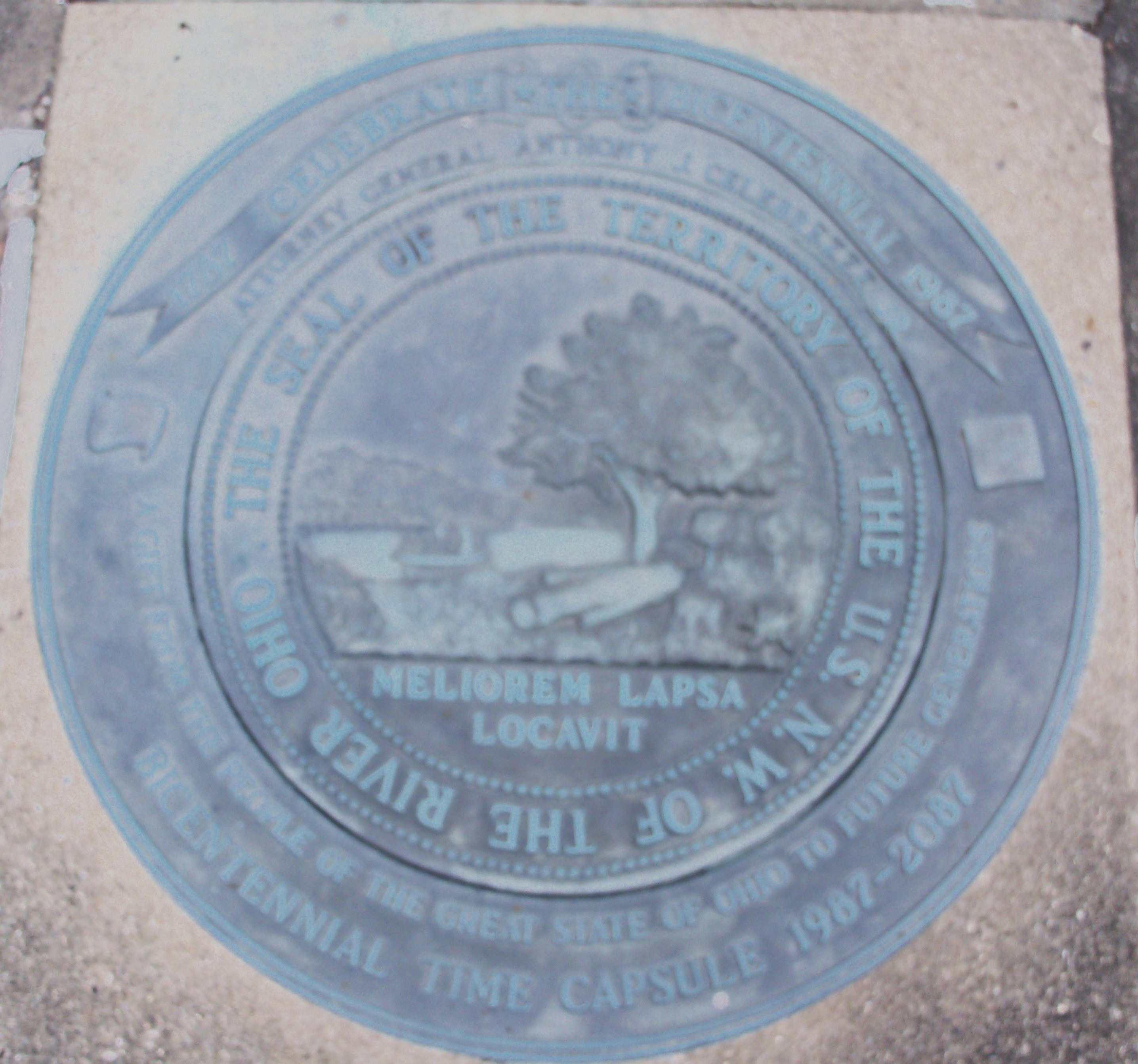
 Plaque at Marietta, Ohio commemorating the first American settlement of the Northwest Territory
 Seal of the Northwest territory over a time capsule outside the Campus Martius Museum. Latin phrase “He has planted one better than the one fallen,” signifies the replacement of wilderness by civilization.[7]
 Ohio Counties in 1802
13 counties were formed by Governor Arthur St. Clair during the territory's existence:
- Washington County, with its seat at Marietta, was the first county formed in the territory, proclaimed on July 26, 1788 by territorial governor St. Clair. Its original boundaries were proclaimed as all of present-day Ohio east of a line extending due south from the mouth of the Cuyahoga River,[8] but this did not take into account Connecticut's still unresolved claim of the Western Reserve. It kept these boundaries until 1796.
- Hamilton County, with its seat at Cincinnati, was proclaimed on January 2, 1790. The same proclamation officially changed Cincinnati's name from Losantiville into its present form. Its original boundaries claimed all land north of the Ohio between the Great Miami and Little Miami Rivers as far north as Standing Stone Fork (now Loramie Creek), just north of present-day Piqua.[9] In 1792 Hamilton County would expand to encompass all lands between the mouths of the Great Miami and Cuyahoga Rivers, as well as all of what is now the Lower Peninsula of Michigan. Its territory would undergo several reductions after 1796.
- St. Clair County, with its seat at Kaskaskia was proclaimed on April 27, 1790. It originally encompassed most of present-day Illinois south of the Illinois River. It lost most of its southern lands in the formation of Randolph County in 1795, necessitating the transfer of the county seat to Cahokia, but would expand to the north to take in northwest present-day Illinois and most of present-day Wisconsin in 1801 after becoming part of Indiana Territory.[10]
- Knox County, with its seat at Vincennes, was proclaimed on June 20, 1790, and encompassed the majority of the territory's land area - all land between St. Clair County and Hamilton County, extending north to Canada.[11]
- Randolph County was formed October 5, 1795 with its seat at Kaskaskia and encompassed the southern half of what was St. Clair County.
- Wayne County was formed on August 15, 1796, out of portions of Hamilton County and unorganized land, with its seat at Detroit, which had been evacuated by the British five weeks previously. Wayne County originally covered all of Michigan's Lower Peninsula, northwestern Ohio, northern Indiana and a small portion of the present Lake Michigan shoreline, including the site of present-day Chicago. The lands west of the extension of the present Indiana-Ohio border would become part of Indiana Territory in 1800; the eastern portion of the county's land in Ohio would be erected into Trumbull County that same year. The part of the territory north of the Ordinance Line would become part of Indiana Territory in 1803 as a reorganized Wayne County; the remainder would revert to an unorganized status after Ohio statehood.
- Adams County was formed on July 10, 1797, with its seat at Manchester; it encompassed most of present-day south central Ohio.
- Jefferson County was formed July 29, 1797 with its seat at Steubenville, carved out of Washington County and originally encompassed all of what is now northeastern Ohio.
- Ross County was organized on August 20, 1798 with its seat at Chillicothe and was carved out of portions of Knox, Hamilton and Washington counties.
Knox, Randolph and St. Clair counties were separated from the territory effective July 4, 1800, and, along with the western part of Wayne County, and unorganized lands in what are now Minnesota and Wisconsin, became the Indiana Territory.
- Trumbull County was proclaimed July 10, 1800 out of the Western Reserve portion of Jefferson and Wayne Counties, with its county seat at Warren, chosen over rivals Cleveland and Youngstown.[2]
- Clermont County was formed December 6, 1800 out of Hamilton County, with its seat at Williamsburg. In contrast with most other Northwest Territory counties, Clermont County's original boundaries are only slightly larger than its present-day limits.
- Fairfield County was proclaimed December 9, 1800 and formed out of Ross and Washington counties, with its seat at Lancaster.
- Belmont County was formed September 7, 1801 out of Washington and Jefferson counties, with its seat at St. Clairsville.
The Northwest Territory ceased to exist upon Ohio statehood on March 1, 1803; the lands in Ohio that were previously part of Wayne County but not included in Trumbull County reverted to an unorganized status until new counties could be formed in the years to come. The remainder of Wayne County, roughly the eastern half of the Lower Peninsula of Michigan and the eastern tip of the Upper Peninsula, was attached to Indiana Territory.
Territorial contributions
-
- U.S. states that ceded territorial claims in what would become the Northwest Territory:
- State of New York, 1780–1782
- Commonwealth of Virginia, 1781–1784
- Commonwealth of Massachusetts, 1784–1785
- State of Connecticut, 1786 and 1800
- U.S. territories that encompassed land that was previously part of the Northwest Territory:
- Territory of Indiana, 1800–1816
- Territory of Michigan, 1805–1837
- Territory of Illinois, 1809–1818
- Territory of Wisconsin, 1836–1848
- Territory of Minnesota, 1849–1858
- U.S. states that encompass land that was once part of the Northwest Territory:
- State of Ohio, 1803
- State of Indiana, 1816
- State of Illinois, 1818
- State of Michigan, 1837
- State of Wisconsin, 1848
- State of Minnesota, 1858
- U.S. states that ceded territorial claims in what would become the Northwest Territory:
See also
- American pioneers to the Northwest Territory
- Historic regions of the United States
- History of Ohio
- Illinois-Wabash Company
- Indian Reserve (1763)
- Northwest Indian War
- Northwest Ordinance
- Northwestern University - Created in 1851 to serve the people of the former Northwest Territory
- Ohio Country
- Zane's trace
References
- ^ Palmer, 400 & 421
- ^ Ohio General Assembly (1917). Manual of legislative practice in the General Assembly. State of Ohio. p. 199. http://books.google.com/books?id=7qesAAAAMAAJ&pg=PA199.
- ^ [1]
- ^ Burtner, Jr, W. H. (1998). Charles Willing Byrd. 41. Ohio Historical Society. p. 237. http://publications.ohiohistory.org/ohstemplate.cfm?action=detail&Page=0041237.html&StartPage=237&EndPage=240&volume=41&newtitle=Volume%2041%20Page%20237
- ^ Hildreth, S. P.: Pioneer History: Being an Account of the First Examinations of the Ohio Valley, and the Early Settlement of the Northwest Territory, H. W. Derby and Co., Cincinnati, Ohio (1848) p. 232–33.
- ^ Zimmer, L: True Stories from Pioneer Valley, Broughton Foods Co., Marietta, Ohio (1987) p. 20.
- ^ Reinke, Edgar C.. "Meliorem Lapsa Locavit: An Intriguing Puzzle Solved". Ohio History 94: 74. http://publications.ohiohistory.org/ohstemplate.cfm?action=detail&Page=009474.html&StartPage=68&EndPage=74&volume=94&newtitle=Volume%2094%20Page%2068. says the young tree on the seal of the NWT is an apple, while Summers, Thomas J. (1903). History of Marietta. Marietta, Ohio: The Leader Publishing Co.. p. 115. http://books.google.com/books?id=6BImAAAAMAAJ. says it is a buckeye, and perhaps the genesis of Ohio’s nickname.
- ^ S.O. Griswold, The Corporate Birth and Growth of the City of Cleveland, Western Reserve and Northern Ohio Historical Society, Tract No. 62, 1884
- ^ Unknown, History of Cincinnati and Hamilton County, S.B. Nelson & Co., 1894
- ^ W.C. Walton, A Brief History of St. Clair County McKendree College, 1928
- ^ Logan Esarey, A History of Indiana W.K. Stewart Co, 1915, p. 137
External links
- Facsimile of 1789 Act
- The Territory's Executive Journal
- Maumee Valley Heritage Corridor
- Prairie Fire: The Illinois Country 1673-1818, Illinois Historical Digitization Projects at Northern Illinois University Libraries
 State of Indiana
Topics - Index
- Demographics
- Economy
- Geography
- Government
- Governor (List)
- Congressional districts (Delegations)
- History
- Hoosiers
- City Nicknames
- National Historic Landmarks
- Sports
- State parks
- Symbols
- Transportation
- Visitor Attractions
- Index of Indiana-related articles
- Outline
Regions - Central Indiana
- East Central Indiana
- Illinois-Indiana-Kentucky Tri-State Area
- Indiana-Kentucky-Ohio Tri-State Area
- Michiana
- Northern Indiana
- Northwest Indiana
- Southern Indiana
- Southwestern Indiana
- Wabash Valley
Largest cities - Indianapolis
- Fort Wayne
- Evansville
- South Bend
- Hammond
- Bloomington
- Gary
- Carmel
- Lafayette
- Muncie
- Anderson
- Terre Haute
- Elkhart
- Kokomo
- Mishawaka
- Richmond
- Columbus
- Lawrence
- Jeffersonville
- Greenwood
- New Albany
- Portage
- Michigan City
- East Chicago
- Goshen
- Marion
- Valparaiso
- Noblesville
- West Lafayette
- Hobart
- Crown Point
- Franklin
- La Porte
- Seymour
- Logansport
- New Castle
- Connersville
- Vincennes
- Bedford
- Jasper
- Washington
- Princeton
- Westfield
Largest towns Counties - Adams
- Allen
- Bartholomew
- Benton
- Blackford
- Boone
- Brown
- Carroll
- Cass
- Clark
- Clay
- Clinton
- Crawford
- Daviess
- Dearborn
- Decatur
- DeKalb
- Delaware
- Dubois
- Elkhart
- Fayette
- Floyd
- Fountain
- Franklin
- Fulton
- Gibson
- Grant
- Greene
- Hamilton
- Hancock
- Harrison
- Hendricks
- Henry
- Howard
- Huntington
- Jackson
- Jasper
- Jay
- Jefferson
- Jennings
- Johnson
- Knox
- Kosciusko
- LaGrange
- Lake
- LaPorte
- Lawrence
- Madison
- Marion
- Marshall
- Martin
- Miami
- Monroe
- Montgomery
- Morgan
- Newton
- Noble
- Ohio
- Orange
- Owen
- Parke
- Perry
- Pike
- Porter
- Posey
- Pulaski
- Putnam
- Randolph
- Ripley
- Rush
- Saint Joseph
- Scott
- Shelby
- Spencer
- Starke
- Steuben
- Sullivan
- Switzerland
- Tippecanoe
- Tipton
- Union
- Vanderburgh
- Vermillion
- Vigo
- Wabash
- Warren
- Warrick
- Washington
- Wayne
- Wells
- White
- Whitley
 State of Michigan
Topics - Index
- Congressional delegation
- Geography
- Governors
- History
- Islands
- Legislature
- Lieutenant Governors
- Lighthouses
- Museums
- National Historic Landmarks
- National Register of Historic Places listings
- People
- State Historic Sites
- State parks
- Supreme Court
- Tallest buildings
- Timeline
- Topics
- Visitor attractions
Regions Largest
Municipalities- Alpena
- Ann Arbor
- Battle Creek
- Bay City
- Bloomfield Township
- Canton Township
- Chesterfield Township
- Clinton Township
- Commerce Township
- Dearborn
- Dearborn Heights
- Detroit
- East Lansing
- Eastpointe
- Farmington Hills
- Flint
- Flint Township
- Georgetown Township
- Grand Rapids
- Holland
- Jackson
- Kalamazoo
- Kentwood
- Lansing
- Lincoln Park
- Livonia
- Macomb Township
- Meridian Township
- Midland
- Muskegon
- Novi
- Pontiac
- Portage
- Redford
- Rochester Hills
- Roseville
- Royal Oak
- Saginaw
- Saginaw Township
- St. Clair Shores
- Shelby Township
- Southfield
- Sterling Heights
- Taylor
- Troy
- Warren
- Waterford Township
- West Bloomfield
- Westland
- Wyoming
- Ypsilanti Township
Counties - Alcona
- Alger
- Allegan
- Alpena
- Antrim
- Arenac
- Baraga
- Barry
- Bay
- Benzie
- Berrien
- Branch
- Calhoun
- Cass
- Charlevoix
- Cheboygan
- Chippewa
- Clare
- Clinton
- Crawford
- Delta
- Dickinson
- Eaton
- Emmet
- Genesee
- Gladwin
- Gogebic
- Grand Traverse
- Gratiot
- Hillsdale
- Houghton
- Huron
- Ingham
- Ionia
- Iosco
- Iron
- Isabella
- Jackson
- Kalamazoo
- Kalkaska
- Kent
- Keweenaw
- Lake
- Lapeer
- Leelanau
- Lenawee
- Livingston
- Luce
- Mackinac
- Macomb
- Manistee
- Marquette
- Mason
- Mecosta
- Menominee
- Midland
- Missaukee
- Monroe
- Montcalm
- Montmorency
- Muskegon
- Newaygo
- Oakland
- Oceana
- Ogemaw
- Ontonagon
- Osceola
- Oscoda
- Otsego
- Ottawa
- Presque Isle
- Roscommon
- Saginaw
- Sanilac
- Schoolcraft
- Shiawassee
- St. Clair
- St. Joseph
- Tuscola
- Van Buren
- Washtenaw
- Wayne
- Wexford
 State of Illinois
Topics - Index
- Buildings and structures
- Communications
- Culture
- Delegations
- Economy
- Education
- Environment
- Geography
- Government
- Health
- History
- Music
- People
- Portal
- Society
- Sports
- Tourism
- Transportation
- Windmills
Regions - American Bottom
- Central Illinois
- Champaign–Urbana metropolitan area
- Chicago metropolitan area
- Driftless Area
- Forgottonia
- Fox Valley
- Illinois–Indiana–Kentucky Tri-State Area
- Metro East
- Mississippi Alluvial Plain
- North Shore
- Northern Illinois
- Northwestern Illinois
- Peoria metropolitan area
- Quad Cities
- River Bend
- Rockford metropolitan area
- Southern Illinois
- Streatorland
- Wabash Valley
Major cities,
towns and villages- Alton/Granite City/Edwardsville
- Arlington Heights/Palatine
- Aurora/Naperville/Oswego/Plainfield
- Bartlett/Hanover Park/Streamwood
- Belleville/East St. Louis/Collinsville/O'Fallon
- Berwyn/Cicero
- Bloomington/Normal
- Bolingbrook/Romeoville
- Buffalo Grove/Wheeling
- Calumet City
- Canton
- Carbondale
- Carol Stream/Glendale Heights
- Centralia
- Champaign/Urbana
- Charleston/Mattoon
- Chicago
- Chicago Heights
- Crystal Lake/Algonquin
- Danville
- Decatur
- DeKalb/Sycamore
- Des Plaines/Mount Prospect/Park Ridge
- Dixon
- Downers Grove/Woodridge
- Effingham
- Elgin/Carpentersville
- Elmhurst/Lombard/Addison
- Evanston/Skokie
- Freeport
- Galesburg
- Glenview/Northbrook
- Harrisburg
- Jacksonville
- Joliet
- Kankakee/Bradley/Bourbonnais
- Lincoln
- Macomb
- Marion/Herrin
- Moline/East Moline/Rock Island
- Mount Vernon
- Mundelein
- Oak Lawn
- Oak Park
- Orland Park/Tinley Park
- Ottawa/Streator/LaSalle/Peru
- Peoria/Pekin/East Peoria/Morton
- Pontiac
- Quincy
- Rochelle
- Rockford/Belvidere/Machesney Park/Loves Park
- St. Charles
- Schaumburg/Hoffman Estates/Elk Grove Village
- Springfield
- Sterling/Rock Falls
- Taylorville
- Waukegan/North Chicago/Gurnee
- Wheaton
Counties - Adams
- Alexander
- Bond
- Boone
- Brown
- Bureau
- Calhoun
- Carroll
- Cass
- Champaign
- Christian
- Clark
- Clay
- Clinton
- Coles
- Cook
- Crawford
- Cumberland
- DeKalb
- DeWitt
- Douglas
- DuPage
- Edgar
- Edwards
- Effingham
- Fayette
- Ford
- Franklin
- Fulton
- Gallatin
- Greene
- Grundy
- Hamilton
- Hancock
- Hardin
- Henderson
- Henry
- Iroquois
- Jackson
- Jasper
- Jefferson
- Jersey
- Jo Daviess
- Johnson
- Kane
- Kankakee
- Kendall
- Knox
- LaSalle
- Lake
- Lawrence
- Lee
- Livingston
- Logan
- Macon
- Macoupin
- Madison
- Marion
- Marshall
- Mason
- Massac
- McDonough
- McHenry
- McLean
- Menard
- Mercer
- Monroe
- Montgomery
- Morgan
- Moultrie
- Ogle
- Peoria
- Perry
- Piatt
- Pike
- Pope
- Pulaski
- Putnam
- Randolph
- Richland
- Rock Island
- Saline
- Sangamon
- Schuyler
- Scott
- Shelby
- St. Clair
- Stark
- Stephenson
- Tazewell
- Union
- Vermilion
- Wabash
- Warren
- Washington
- Wayne
- White
- Whiteside
- Will
- Williamson
- Winnebago
- Woodford
 State of Wisconsin
Topics - History
- Governors
- Delegations
- Sports
- People
- Geography
- Demographics
- Economy
- Visitor Attractions
Regions Major metropolitan areas
(pop. over 500,000)- Chicago metropolitan area
- Madison metropolitan area
- Milwaukee metropolitan area
- Twin Cities metropolitan area
Largest cities
(pop. over 50,000)Smaller cities
(pop. 15,000 to 50,000)Largest villages
(pop. over 15,000)Counties - Adams
- Ashland
- Barron
- Bayfield
- Brown
- Buffalo
- Burnett
- Calumet
- Chippewa
- Clark
- Columbia
- Crawford
- Dane
- Dodge
- Door
- Douglas
- Dunn
- Eau Claire
- Florence
- Fond du Lac
- Forest
- Grant
- Green
- Green Lake
- Iowa
- Iron
- Jackson
- Jefferson
- Juneau
- Kenosha
- Kewaunee
- La Crosse
- Lafayette
- Langlade
- Lincoln
- Manitowoc
- Marathon
- Marinette
- Marquette
- Menominee
- Milwaukee
- Monroe
- Oconto
- Oneida
- Outagamie
- Ozaukee
- Pepin
- Pierce
- Polk
- Portage
- Price
- Racine
- Richland
- Rock
- Rusk
- Sauk
- Sawyer
- Shawano
- Sheboygan
- St. Croix
- Taylor
- Trempealeau
- Vernon
- Vilas
- Walworth
- Washburn
- Washington
- Waukesha
- Waupaca
- Waushara
- Winnebago
- Wood
 State of Minnesota
Topics - Index
- Cities
- Climate
- Colleges and universities
- Congressional districts
- Demographics
- Ecology
- Economy
- Geography
- Geology
- Governors
- High schools
- Historical Congressional delegations
- Historical Landmarks
- History
- Lakes
- Movies and television
- Music
- People
- Political parties
- Rivers
- School districts
- Scouting
- Sports
- State fair
- State parks
- Territory
- Townships
- Transportation
- Visitor Attractions
Regions Larger cities
pop. over 60,000Smaller cities
pop. over 10,000- Albert Lea
- Alexandria
- Andover
- Anoka
- Apple Valley
- Austin
- Bemidji
- Big Lake
- Blaine
- Brainerd
- Brooklyn Center
- Buffalo
- Champlin
- Chanhassen
- Chaska
- Cloquet
- Columbia Heights
- Cottage Grove
- Crystal
- East Bethel
- Edina
- Elk River
- Fairmont
- Faribault
- Farmington
- Fergus Falls
- Forest Lake
- Fridley
- Golden Valley
- Grand Rapids
- Ham Lake
- Hastings
- Hibbing
- Hopkins
- Hugo
- Hutchinson
- Inver Grove Heights
- Lakeville
- Lino Lakes
- Mankato
- Maplewood
- Marshall
- Mendota Heights
- Minnetonka
- Monticello
- Moorhead
- Mounds View
- New Brighton
- New Hope
- New Ulm
- North Branch
- North Mankato
- North St. Paul
- Northfield
- Oakdale
- Otsego
- Owatonna
- Prior Lake
- Ramsey
- Red Wing
- Richfield
- Robbinsdale
- Rosemount
- Roseville
- Sartell
- Sauk Rapids
- Savage
- Shakopee
- Shoreview
- South St. Paul
- St. Louis Park
- St. Michael
- St. Peter
- Stillwater
- Vadnais Heights
- Waconia
- West St. Paul
- White Bear Lake
- Willmar
- Winona
- Worthington
Counties - Aitkin
- Anoka
- Becker
- Beltrami
- Benton
- Big Stone
- Blue Earth
- Brown
- Carlton
- Carver
- Cass
- Chippewa
- Chisago
- Clay
- Clearwater
- Cook
- Cottonwood
- Crow Wing
- Dakota
- Dodge
- Douglas
- Faribault
- Fillmore
- Freeborn
- Goodhue
- Grant
- Hennepin
- Houston
- Hubbard
- Isanti
- Itasca
- Jackson
- Kanabec
- Kandiyohi
- Kittson
- Koochiching
- Lac qui Parle
- Lake
- Lake of the Woods
- Le Sueur
- Lincoln
- Lyon
- Mahnomen
- Marshall
- Martin
- McLeod
- Meeker
- Mille Lacs
- Morrison
- Mower
- Murray
- Nicollet
- Nobles
- Norman
- Olmsted
- Otter Tail
- Pennington
- Pine
- Pipestone
- Polk
- Pope
- Ramsey
- Red Lake
- Redwood
- Renville
- Rice
- Rock
- Roseau
- St. Louis
- Scott
- Sherburne
- Sibley
- Stearns
- Steele
- Stevens
- Swift
- Todd
- Traverse
- Wabasha
- Wadena
- Waseca
- Washington
- Watonwan
- Wilkin
- Winona
- Wright
- Yellow Medicine
Categories:- States and territories established in 1787
- States and territories disestablished in 1803
- History of the Midwestern United States
- Northwest Territory
- Midwestern United States


Wikimedia Foundation. 2010.