- Pomponius Mela
-
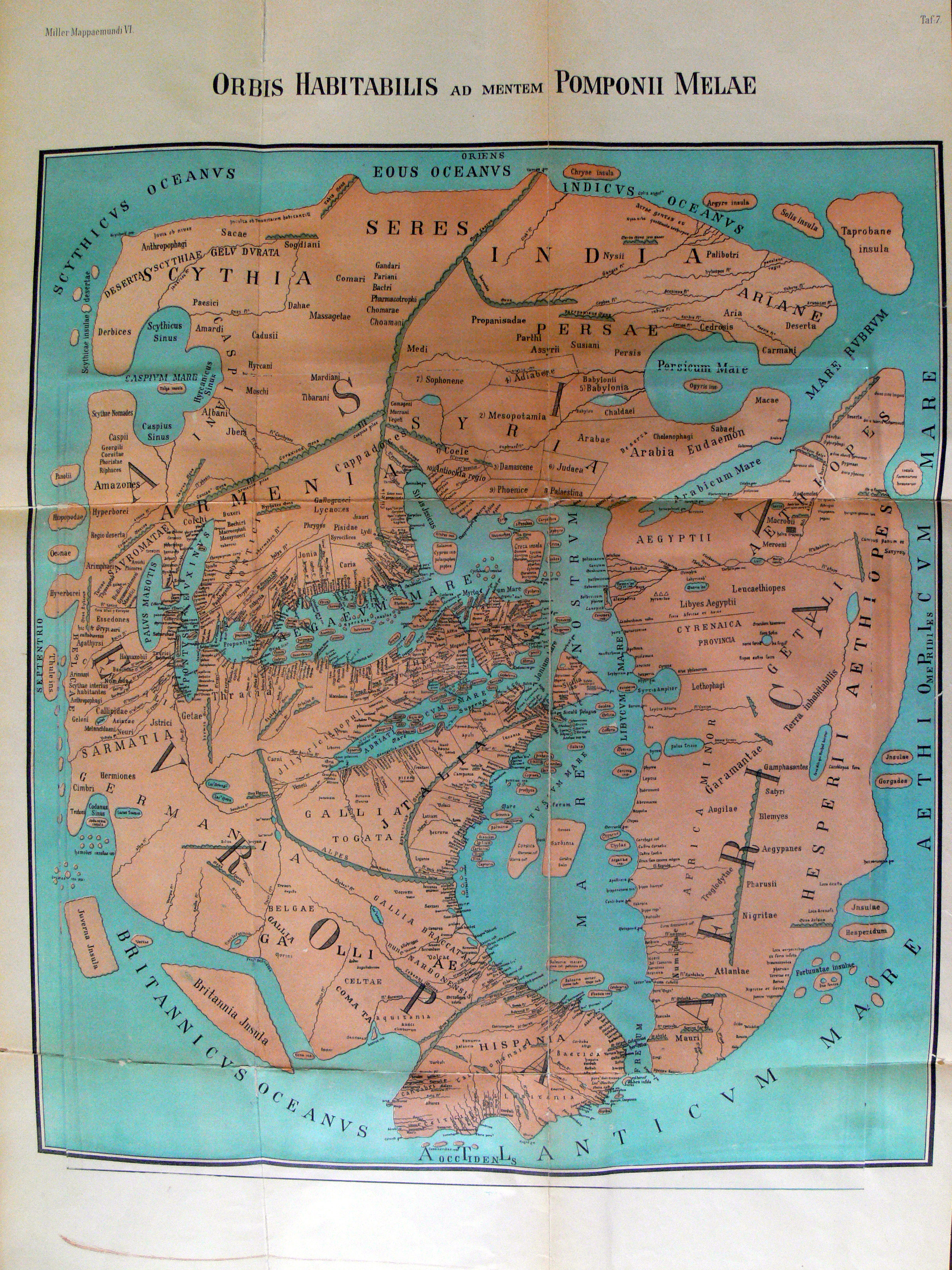
 Depiction of Pomponius Mela's geographical view of the World..
 Description of Europe by Pomponius Mela
Pomponius Mela, who wrote around AD 43, was the earliest Roman geographer. He was born in Tingentera (Algeciras) and died c. AD 45.[1]
His short work (De situ orbis libri III.) occupies less than one hundred pages of ordinary print. It is laconic in style and deficient in method, but of pure Latinity, and occasionally relieved by pleasing word-pictures. Excepting the geographical parts of Pliny's Historia naturalis (where Mela is cited as an important authority) the De situ orbis is the only formal treatise on the subject in Classical Latin.
Contents
Biography
Little is known of the author except his name and birthplace—the small town of Tingentera or Cingentera in southern Spain, on Algeciras Bay (Mela ii. 6, § 96; but the text is here corrupt). The date of his writing may be approximately fixed by his allusion (iii. 6 § 49) to a proposed British expedition of the reigning emperor, almost certainly that of Claudius in AD 43. That this passage cannot refer to Julius Caesar is evidenced by several references to events of Augustus's reign, especially to certain new names given to Spanish towns. Mela has been without probability identified by some with L. Annaeus Mela of Corduba, son of the rhetorician Seneca the Elder, and brother of the philosopher Seneca the Younger.
Geographical knowledge
The general views of the De situ orbis mainly agree with those current among Greek writers from Eratosthenes to Strabo; the latter was probably unknown to Mela. But Pomponius is unique among ancient geographers in that, after dividing the earth into five zones, of which two only were habitable, he asserts the existence of antichthones, inhabiting the southern temperate zone inaccessible to the folk of the northern temperate regions from the unbearable heat of the intervening torrid belt. On the divisions and boundaries of Europe, Asia and Africa, he repeats Eratosthenes; like all classical geographers from Alexander the Great (except Ptolemy) he regards the Caspian Sea as an inlet of the Northern Ocean, corresponding to the Persian and Arabian (Red Sea) gulfs on the south.
 The shores of Codanus sinus (southwestern Baltic Sea) in red with its many islands in green.
His Indian conceptions are inferior to those of some earlier Greek writers; he follows Eratosthenes in supposing that country to occupy the south-eastern angle of Asia, whence the coast trended northwards to Scythia, and then swept round westward to the Caspian Sea. As usual, he places the Rhipaean Mountains and the Hyperboreans near the Scythian Ocean. In western Europe his knowledge (as was natural in a Spanish subject of Imperial Rome) was somewhat in advance of the Greek geographers. He defines the western coast-line of Spain and Gaul and its indentation by the Bay of Biscay more accurately than Eratosthenes or Strabo, his ideas of the British Isles and their position are also clearer than his predecessors. He is the first to name the Orcades or Orkney Islands, which he defines and locates pretty correctly. Of northern Europe his knowledge was imperfect, but he speaks of a great bay ("Codanus sinus") to the north of Germany, among whose many islands was one, "Codanovia," of pre-eminent size; this name reappears in Pliny the Elder's work as Scatinavia. Codanovia and Scatinavia were both Latin renderings of the Proto-Germanic *Skaðinawio, the Germanic name for Scandinavia.[citation needed]
Descriptive method
Mela's descriptive method is peculiar and inconvenient. Instead of treating each continent separately he begins at the Straits of Gibraltar, and describes the countries adjoining the south coast of the Mediterranean; then he moves round by Syria and Asia Minor to the Black Sea, and so returns to Spain along the north shore of the Euxine, Propontis, etc. After treating the Mediterranean islands, he next takes the ocean littoral—to west, north, east and south successively—from Spain and Gaul round to India, from India to Persia, Arabia and Ethiopia; and so again works back to Spain round South Africa. Like most classical geographers he conceives of the continent as surrounded by sea and not extending very far south.
Editions
The first edition of Mela was published at Milan in 1471; the first good edition was by Vadianus (Basel, 1522), superseded by those of Voss (1658), J Gronovius (1685 and 1696), A Gronovius (1722 and 1728), and Tzschucke (1806–1807), in seven parts (Leipzig; the most elaborate of all); G Paithey's (Berlin, 1867), gives the best text. The English trans. by Arthur Golding (1585), is famous; see also EH Bunbury, Ancient Geography, ii. 352?368, and D Detlefsen, Quellen und Forschungen zur alten Gesch. und Geog. (1908). The only recent English translation is that of F. E. Romer, originally published in 1998.
External links
References
 This article incorporates text from a publication now in the public domain: Chisholm, Hugh, ed (1911). Encyclopædia Britannica (11th ed.). Cambridge University Press.
- ^ Tegg, Thomas (1824). Chronology, or The historian's companion (Third ed.). Thomas Tegg. p. 284. http://books.google.com/books?id=-9IGAAAAQAAJ&pg=PP1&dq=Tegg,+Thomas+%281824%29#v=onepage&q&f=false.
Categories:- 45 deaths
- Roman era geographers
- 1st-century Romans
- Romans from Hispania


Wikimedia Foundation. 2010.