- East New York (LIRR station)
-
East New York 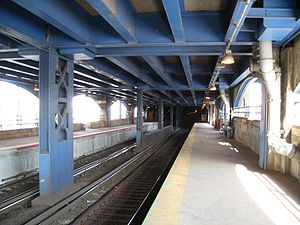
Looking eastStation statistics Address Atlantic Avenue & Havens Place
East New York, New YorkCoordinates 40°40′34″N 73°54′21″W / 40.676053°N 73.905925°WCoordinates: 40°40′34″N 73°54′21″W / 40.676053°N 73.905925°W Lines Connections New York City Subway:
 at Atlantic Avenue


 at Broadway Junction
 New York City Bus: B12, B20, B25, B83, Q24, Q56
Platforms 2 side platforms Tracks 2 Other information Opened 1878 Electrified July 26, 1905
750V (DC) third railOwned by MTA Fare zone 1 Formerly Manhattan Beach Railroad Crossing Traffic Passengers (2006) 1,127[1] Services Preceding station LIRR Following station toward Atlantic TerminalAtlantic Branch
(City Terminal Zone)Boland's Landing(employees only)toward Long Island East New York Station in 1873
 Eastbound entrance
East New York is a station on the Long Island Rail Road's Atlantic Branch in East New York, Brooklyn, where that branch passes through the historic Jamaica Pass. It is located at ground level, in the median of Atlantic Avenue, and underneath the elevated main lanes of Atlantic Avenue, with one side platform on either side of the two-track line. This part of the Atlantic Branch is fully grade-separated, and goes down into a tunnel on each side of the station, allowing the Atlantic Avenue main lanes to return to the surface. The only crossings of Atlantic Avenue here are the freight tunnel on the LIRR Bay Ridge Branch, a tunnel carrying East New York Avenue diagonally under the area, and the elevated BMT Canarsie Line (L train) – and formerly also the BMT Fulton Street Line – which passes over Atlantic Avenue. The Atlantic Avenue elevated New York City Subway station lies along this line, directly over the East New York LIRR station.
The station is served by the Far Rockaway Branch, the Hempstead Branch and the West Hempstead Branch of the LIRR.
East New York has two side platforms capable of holding a 10-car train. A ticket office is located in the station. It is located in the City Terminal Zone, and in turn located within Zone 1. This station is also included within the CityTicket program.
Contents
History
When the Brooklyn and Jamaica Railroad opened in 1836, under lease to the LIRR, it did not include a station at East New York.[citation needed] The LIRR began stopping at East New York by early 1843,[2] eventually stopping at the Howard House at Alabama Avenue, shared with all the other horse car and steam lines into East New York.[3] From 1861 to 1877, East New York served as the west end of steam service along the Atlantic Branch.[citation needed]
By 1878, local Atlantic Avenue rapid transit trains began stopping at a new station, Manhattan Beach Railroad Crossing, at the New York and Manhattan Beach Railway crossing at Van Sinderen Avenue. This later became the main East New York station, with only these local trains stopping at Howard House.[4] The Atlantic Avenue Improvement, completed in 1905, resulted in the closing of the Howard House station, and the expanded Manhattan Crossing station was renamed East New York. The elevated Warwick Street station, 18 blocks east, was also labeled as serving East New York;[5] it closed in 1939, when the elevated railway east of East New York was buried in the current tunnel.[citation needed]
East New York was also a station on the New York and Manhattan Beach Railway, now the Bay Ridge Branch, from its opening in July 1877 until May 1924, when passenger service on the branch ended. It was initially at grade level where the lines crossed, but was placed in a tunnel in 1915; the platforms, under East New York Avenue, still exist. Until the 1930s, a grade-level freight connection existed in the southeast quadrant between the two lines.[6]
Platforms and tracks
The station has two high-level side platforms, each 10 cars long. The north platform next to Track 1 is generally used by westbound or Atlantic Terminal-bound trains. The south platform next to Track 2 is generally used by eastbound or Long Island-bound trains. The Atlantic Branch has two tracks here.
References
- ^ Average weekday, 2006 LIRR Origin and Destination Study
- ^ "Long Island Railroad Co". Brooklyn Daily Eagle: p. 3. March 4, 1843. http://eagle.brooklynpubliclibrary.org/Default/Scripting/ArchiveView.asp?BaseHref=BEG/1843/03/04&Page=3&skin=BE.
- ^ "A Model Mass Meeting". Brooklyn Daily Eagle: p. 2. July 22, 1870. http://eagle.brooklynpubliclibrary.org/Default/Scripting/ArchiveView.asp?BaseHref=BEG/1870/07/22&Page=2&skin=BE.
- ^ Employee timetables, November 4, 1878 and summer 1897
- ^ Employee timetables, 1905
- ^ Abandoned Stations: East New York
External links
Categories:- Transportation in Brooklyn
- Long Island Rail Road stations


Wikimedia Foundation. 2010.