Massachusetts Bay

Massachusetts Bay
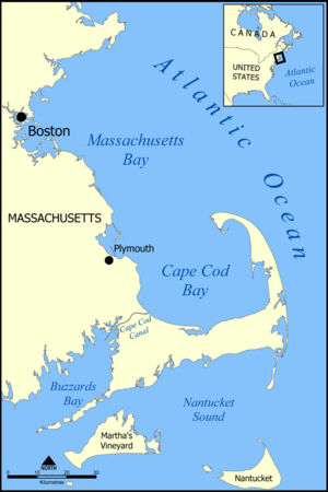
Map of Massachusetts Bay.

The Massachusetts Bay, also called Mass Bay, is one of the largest bays of the Atlantic Ocean which forms the distinctive shape of the coastline of the U.S. state of Massachusetts. Its waters extend 65 miles (105 km) into the Atlantic Ocean.[citation needed] Massachusetts Bay includes the Boston Harbor, Dorchester Bay, Quincy Bay (both part of the Outer Boston Harbor), and Hingham Bay. Massachusetts Bay is itself part of the Gulf of Maine, which reaches from Cape Cod up to Nova Scotia.

The bay is enclosed on the north by Cape Ann. Just south is Cape Cod Bay. Cape Cod Bay is sometimes construed as part of Massachusetts Bay; under this interpretation, the name "Massachusetts Bay" denotes the entire rectangular area of ocean between Cape Ann and Cape Cod. The bay's westernmost point is situated at Boston.

The bay gave its name to the Massachusetts Bay Colony, one of the two predecessor colonies of the current state of Massachusetts. Massachusetts Bay, along with Quincy Bay, Narragansett Bay, Buzzards Bay and Cape Cod Bay, is also one of the bays adjacent to Massachusetts that give the commonwealth the nickname "the Bay State".

Coordinates: 42°22′30″N 70°44′58″W / 42.375°N 70.74944°W / 42.375; -70.74944


Wikimedia Foundation. 2010.

Игры ⚽ Нужно решить контрольную?

Look at other dictionaries:

  • Massachusetts Bay — inlet of the Atlantic, on the E coast of Mass …   English World dictionary

  • Massachusetts-Bay — Karte der Massachusetts Bucht Die Massachusetts Bucht (engl. Massachusetts Bay) ist eine der größten Buchten der amerikanischen Atlantikküste. Sie bildet die etwa 100 km lange charakteristische Küstenlinie des US Staates Massachusetts. Die Bucht… …   Deutsch Wikipedia

  • Massachusetts Bay — Karte der Massachusetts Bucht Die Massachusetts Bucht (engl. Massachusetts Bay) ist eine der größten Buchten der amerikanischen Atlantikküste. Sie bildet die etwa 100 km lange charakteristische Küstenlinie des US Staates Massachusetts. Die Bucht… …   Deutsch Wikipedia

  • Massachusetts Bay — an inlet of the Atlantic, off the E coast of Massachusetts. * * * ▪ inlet, Massachusetts, United States       inlet of the North Atlantic Ocean, extending southward for about 60 miles (100 km) from Cape Ann (Ann, Cape) to Cape Cod (Cod, Cape),… …   Universalium

  • Massachusetts Bay — Sp Masačùsetso įlanka Ap Massachusetts Bay L V Atlante, JAV (Masačusetsas) …   Pasaulio vietovardžiai. Internetinė duomenų bazė

  • Massachusetts Bay Colony — Colony of England …   Wikipedia

  • Massachusetts Bay Transportation Authority — The MBTA provides services in five different modes (boat not pictured) around Greater Boston …   Wikipedia

  • Massachusetts Bay Trading Company — Type Private Founded 2002 Headquarters Weston, MA Key people Robert Nilsson, President Products Retail Website …   Wikipedia

  • Massachusetts Bay Community College — Established 1961 Type Public President Car …   Wikipedia

  • Massachusetts Bay Transportation Authority v. Anderson — United States District Court for the District of Massachusetts Filed August 8, 2008 Decided August 19, 2008 Case name Massachusetts Bay Transportation Authority v. Zack Anderson, RJ Ryan, Alessandro Chiesa, and the Massachusetts Institute of… …   Wikipedia

Share the article and excerpts

Direct link
Do a right-click on the link above
and select “Copy Link”