- Lake Nyos
-
For School level education board in India, see NIOS."nyos" redirects here. For information about youth orchestra, see National Youth Orchestra of Scotland.
Lake Nyos 
Location Northwest Province Coordinates 06°26′17″N 010°17′56″E / 6.43806°N 10.29889°ECoordinates: 06°26′17″N 010°17′56″E / 6.43806°N 10.29889°E Lake type Meromictic, crater lake Primary inflows subaquatic source Basin countries Cameroon Max. length 2.0 km (1.2 mi) Max. width 1.2 km (0.75 mi) Surface area 1.58 km2 (390 acres) Max. depth 208 m (682 ft) Water volume 0.15 km3 (120,000 acre·ft) Surface elevation 1,091 m (3,579 ft) Lake Nyos is a crater lake in the Northwest Region of Cameroon, located about 200 miles (322 km) northwest of Yaoundé.[1] Nyos is a deep lake high on the flank of an inactive volcano in the Oku volcanic plain along the Cameroon line of volcanic activity. A natural dam of volcanic rock contains the lake waters.
A pocket of magma lies beneath the lake and leaks carbon dioxide (CO2) into the water, changing it into carbonic acid. Nyos is one of only three known exploding lakes to be saturated with carbon dioxide in this way, the others being Lake Monoun, 100 km (62 mi) away SSE, and Lake Kivu in Democratic Republic of Congo. On August 21, 1986, possibly triggered by a landslide, Lake Nyos suddenly emitted a large cloud of CO2, which suffocated 1,700 people and 3,500 livestock in nearby towns and villages.[2] Though not completely unprecedented, it was the first known large-scale asphyxiation caused by a natural event. To prevent a recurrence, a degassing tube that syphons water from the bottom layers of water to the top allowing the carbon dioxide to leak in safe quantities was installed in 2001, though additional tubes are needed to make the lake safe.[3]
Today, the lake also poses a threat due to its weakening natural wall. A geological tremor could cause this natural dike to give way, allowing water to rush into downstream villages all the way into Nigeria and allowing much carbon dioxide to escape.
Contents
Setting
Lake Nyos lies within the Oku Volcanic Field, located near the northern boundary of the Cameroon Volcanic Line, a zone of volcanoes and other tectonic activity that extends southwest to the Mt. Cameroon stratovolcano. The field consists of volcanic maars and basaltic scoria cones.[4]
Formation and geological history
Lake Nyos is located south of the dirt road from Wum, about 30 km (19 mi) to the west, to Nkambe in the east. Villages along the road in the vicinity of the lake include Cha, Nyos, Munji, Djingbe, and Subum. The lake is 50 km (31 mi) from the Nigerian border to the north, and lies on the northern slopes of the Massif du Mbam, drained by streams running north, then northwest, to the Katsina-Ala River in Nigeria which is part of the Benue River basin.[5]
Lake Nyos fills a roughly circular maar in the Oku Volcanic Field, an explosion crater caused when a lava flow interacted violently with groundwater. The maar is believed to have formed in an eruption about 400 years ago, and is 1,800 m (5,900 ft) across and 208 m (682 ft) deep.[6] The area has been volcanically active for millions of years—after South America and Africa were split apart by plate tectonics about 110 million years ago, West Africa also experienced rifting, although to a lesser degree. The rift is known as the Mbéré Rift Valley, and crustal extension has allowed magma to reach the surface along a line extending through Cameroon. Mount Cameroon also lies on this fault line. Lake Nyos is surrounded by old lava flows and pyroclastic deposits.
Although Nyos is situated within an extinct volcano, magma still exists beneath it. Approximately 50 miles (80 km) directly below the lake resides a pool of magma, which lets off carbon dioxide and other gases; the gasses then travel upward through the earth. The fumes are then ensnared by the natural springs encircling the lake, ultimately rising to the surface of the water and leading into the lake.[7]
The lake waters are held in place by a natural dam composed of volcanic rock. At its narrowest point, the wall measures 40 metres (130 ft) high and 45 metres (148 ft) wide.
Gas saturation
Lake Nyos is one of only three lakes in the world known to be saturated with carbon dioxide—the others are Lake Monoun, also in Cameroon, and Lake Kivu in Democratic Republic of Congo. A magma chamber beneath the region is an abundant source of carbon dioxide, which seeps up through the lake bed, charging the waters of Lake Nyos with an estimated 90 million tonnes of CO2.
Lake Nyos is thermally stratified, with layers of warm, less dense water near the surface floating on the colder, denser water layers near the lake's bottom. Over long periods, carbon dioxide gas seeping into the cold water at the lake's bottom is dissolved in great amounts.
Most of the time, the lake is stable and the CO2 remains in solution in the lower layers. However, over time the water becomes supersaturated, and if an event such as an earthquake or landslide occurs, large amounts of CO2 may suddenly come out of solution.
The 1986 disaster
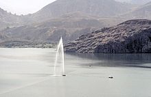
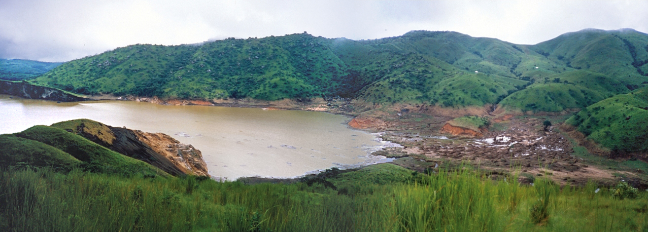
 Lake Nyos as it appeared fewer than two weeks after the eruption; August 29, 1986.
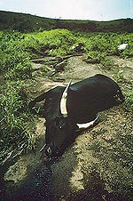 A cow suffocated by gases from Lake Nyos
Although a sudden outgassing of CO2 had occurred at Lake Monoun in 1984, killing 37 local residents, a similar threat from Lake Nyos was not anticipated. However, on August 21, 1986, a limnic eruption occurred at Lake Nyos which triggered the sudden release of about 1.6 million tonnes of CO2; this cloud rose at nearly 100 kilometres per hour (62 mph).[4] The gas spilled over the northern lip of the lake into a valley running roughly east-west from Cha to Subum, and then rushed down two valleys branching off it to the north, displacing all the air and suffocating some 1,700 people within 25 kilometres (16 mi) of the lake, mostly rural villagers, as well as 3,500 livestock. The worst affected villages were Cha, Nyos, and Subum.[8] Scientists concluded from evidence that a 300-foot (91 m) fountain of water and foam formed at the surface of the lake. The huge amount of water rising suddenly caused much turbulence in the water, spawning a wave of at least 80 feet (24 m) that would scour the shore of one side.[9]
One survivor, Joseph Nkwain from Subum, described himself when he awoke after the gases had struck:
"I could not speak. I became unconscious. I could not open my mouth because then I smelled something terrible . . . I heard my daughter snoring in a terrible way, very abnormal . . . When crossing to my daughter's bed . . . I collapsed and fell. I was there till nine o'clock in the (Friday) morning . . . until a friend of mine came and knocked at my door . . . I was surprised to see that my trousers were red, had some stains like honey. I saw some . . . starchy mess on my body. My arms had some wounds . . . I didn't really know how I got these wounds . . .I opened the door . . . I wanted to speak, my breath would not come out . . . My daughter was already dead . . . I went into my daughter's bed, thinking that she was still sleeping. I slept till it was 4:30 p.m. in the afternoon . . . on Friday. (Then) I managed to go over to my neighbors' houses. They were all dead . . . I decided to leave . . . . (because) most of my family was in Wum . . . I got my motorcycle . . . A friend whose father had died left with me (for) Wum . . . As I rode . . . through Nyos I didn't see any sign of any living thing . . . (When I got to Wum), I was unable to walk, even to talk . . . my body was completely weak."[4][10]
Carbon dioxide, being about 1.5 times as dense as air, caused the cloud to "hug" the ground and descend down the valleys where various villages were located. The mass was about 50 metres (164 ft) thick and it travelled downward at a rate of 20–50 kilometres per hour (12–31 mph). For roughly 23 kilometres (14 mi) the cloud remained condensed and dangerous, suffocating many of the people sleeping in Nyos, Kam, Cha, and Subum.[4] About 4,000 inhabitants fled the area, and many of these developed respiratory problems, lesions, and paralysis as a result of the gases.[11]
It is not known what triggered the catastrophic outgassing. Most geologists suspect a landslide, but some believe that a small volcanic eruption may have occurred on the bed of the lake. A third possibility is that cool rainwater falling on one side of the lake triggered the overturn. Others still believe there was a small earthquake, but as witnesses did not report feeling any tremors on the morning of the disaster, this hypothesis is unlikely. Whatever the cause, the event resulted in the rapid mixing of the supersaturated deep water with the upper layers of the lake, where the reduced pressure allowed the stored CO2 to effervesce out of solution.
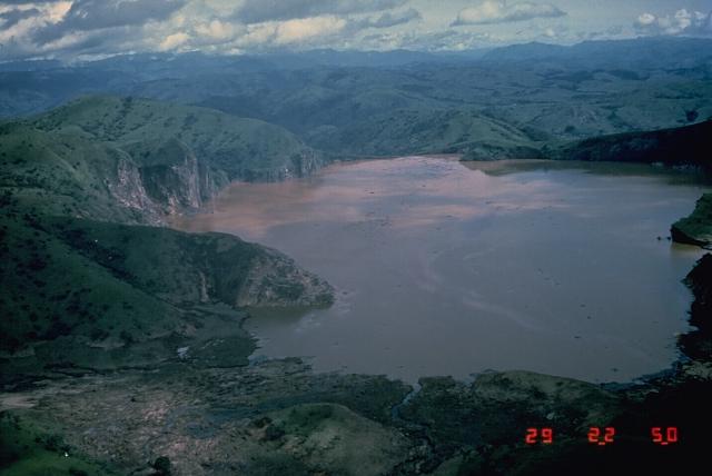
It is believed that about 1.2 cubic kilometres (0.29 cu mi) of gas was released.[12] The normally blue waters of the lake turned a deep red after the outgassing, due to iron-rich water from the deep rising to the surface and being oxidised by the air. The level of the lake dropped by about a metre and trees near the lake were knocked down.
Medical problems
Following the eruption, many survivors were treated at the main hospital in Yaoundé, the country's capital. It was believed that many of the victims had been poisoned by a mixture of gases including hydrogen and sulfur gases. Poisoning by these gases would lead to burning pains in the eyes and nose, coughing and signs of asphyxiation similar to being strangled, as like "being gassed by a kitchen stove".[1]
Following the disaster, the lake was dubbed the "Deadliest lake" by Guinness World Records in 2008.[13]
Degassing
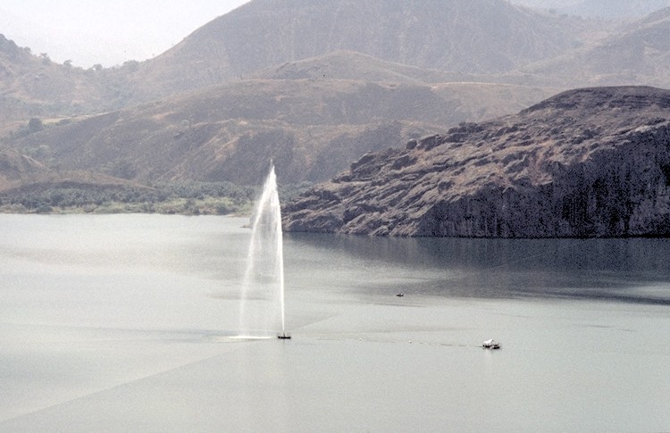
 French scientists working on degassing Lake Nyos
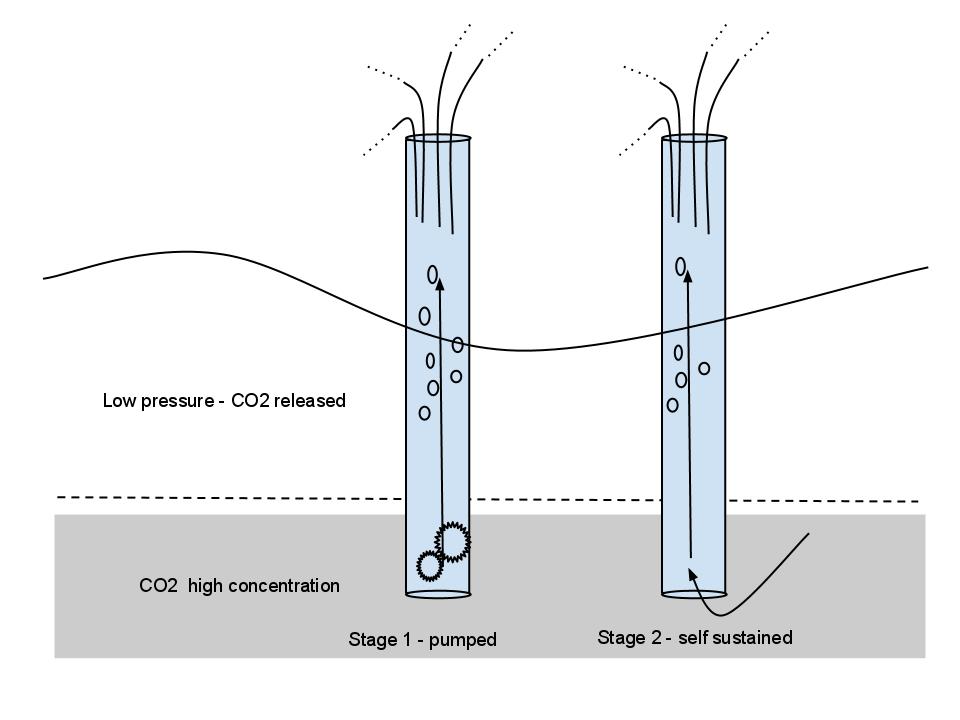
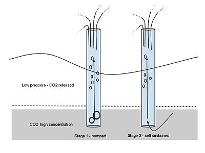 Degassing pump schematic
The scale of the disaster led to much study on how a recurrence could be prevented. Estimates of the rate of carbon dioxide entering the lake suggested that outgassings could occur every 10–30 years, though a recent study shows that release of water from the lake, caused by erosion of the natural barrier that keeps in the lake's water, could in turn reduce pressure on the lake's carbon dioxide and cause a gas escape much sooner.
Several researchers independently proposed the installation of degassing columns from rafts in the lake. The principle is simple: a pump lifts water from the bottom of the lake, heavily saturated with CO2, until the loss of pressure begins releasing the gas from the diphasic fluid and thus makes the process self-powered.[14] In 1992 at Monoun, and in 1995 at Nyos, a French team demonstrated the feasibility of this approach. In 2001, the US Office of Foreign Disaster Assistance funded a permanent installation at Nyos.[15]
More pipes are expected to be needed to make the lake safe: the original French estimates called for a total of five, and the current OFDA project calls for an additional two pipes, each with ten times the capacity of the single current pipe.
Following the Lake Nyos tragedy, scientists investigated other African lakes to see if a similar phenomenon could happen elsewhere. Lake Kivu in Democratic Republic of Congo, 2,000 times larger than Lake Nyos, was also found to be supersaturated, and geologists found evidence for outgassing events around the lake about every thousand years. The eruption of nearby Mount Nyiragongo in 2002 sent lava flowing into the lake, raising fears that a gas eruption could be triggered, but fortunately it was not, as the flow of lava stopped well before it got near the bottom layers of the lake where the gas is maintained in solution by the water pressure.
Weakening dam
On August 18, 2005, Dr. Isaac Njilah, a geologist at the University of Yaoundé, suggested that the natural dam of volcanic rock that keeps in the lake's waters could collapse in the near future. Erosion has worn the dam away, causing holes and pockets to develop in the dam's upper layer, and water already passes through the lower section. Meanwhile, landslides have reduced dam strength on the outside. Seismic activity caused by the lake's volcanic foundation could thus cause the lake wall to give way, resulting in up to 50 million cubic metres (1.8 billion cu ft) of water flooding downhill into areas of the Northwest Province and the Nigerian states of Taraba and Benue. Dr. Njilah estimates that the area is home to more than 10,000 people.[16]
The Cameroonian government, speaking through Dr. Gregory Tanyi-Leke of the Institute of Mining and Geological Research, acknowledges the weakening wall but denies that it presents any immediate threat. A United Nations team led by Olaf Van Duin and Nisa Nurmohamed of the Netherlands Ministry of Transport and Public Works inspected the dam over three days in September 2005 and confirmed that the natural lip had weakened. Van Duin believed that the dam would breach within the next 10 or 20 years.[17]
One possible means of averting such a catastrophe would be to strengthen the lake wall, though this would take much time and money. Engineers could also introduce a channel to allow excess water to drain; if the water level were lowered by about 20 metres (66 ft), the pressure on the wall would be reduced significantly[18].
Return of population
Despite the risks from carbon dioxide and collapse of the lake's retaining wall, the area is being resettled. There is impatience with the apparent slowness of international organisations – Cameroon, UNDP, European Union – to implement improvements in infrastructure and safety projects at the lake. Settlers cite the wish to return to ancestral lands (although some are newcomers) and the great fertility of the land as reasons for their return.[19]
See also
References
- ^ a b BBC contributors (August 21, 1986). "21 August: 1986: Hundreds gassed in Cameroon lake disaster". BBC. http://news.bbc.co.uk/onthisday/hi/dates/stories/august/21/newsid_3380000/3380803.stm. Retrieved December 19, 2008.
- ^ New York Times, "Trying to Tame the Roar of Deadly Lakes", February 27, 2001. [1].
- ^ Degassing Lakes Nyos and Monoun: Defusing certain disaster, Proceedings of the National Academy of the Sciences, October 4, 2005, vol. 102, no. 40, 14185-14190
- ^ a b c d "Lake Nyos (1986)". San Diego State University. March 31, 2006. http://www.geology.sdsu.edu/how_volcanoes_work/Nyos.html. Retrieved December 19, 2008.
- ^ "Map of Wum, Cameroon". MSN Encarta World Atlas.
- ^ "Oku Volcanic Field". Global Volcanism Program, Smithsonian Institution. http://www.volcano.si.edu/world/volcano.cfm?vnum=0204-03-. Retrieved 1999.
- ^ Micah Fink. [avageplanet/01volcano/01/indexmid.html "Degassing Lake Nyos"]. Public Broadcasting Service (PBS). avageplanet/01volcano/01/indexmid.html. Retrieved December 24, 2008.
- ^ Jill Smolowe: "Cameroon the Lake of Death". Time Magazine, Monday, Sep. 08, 1986.
- ^ David Brown (February 1, 2000). "Scientists hope to quiet Cameroon's killer lakes". The Washington Post. http://community.seattletimes.nwsource.com/archive/?date=20000201&slug=4002291. Retrieved December 19, 2008.
- ^ A. Scarth. USGS, 1999.
- ^ Lake Nyos disaster, Cameroon, 1986: the medical effects of large scale emission of carbon dioxide?, BMJ, Volume 298, 27 May 1989, [2]
- ^ "The Strangest Disaster of the 20th Century". Neatorama. 21 May 2007. http://www.neatorama.com/2007/5/21/the-strangest-disaster-of-the-20th-century/. Retrieved 20 June 2010.
- ^ Guinness World Records Editors (2007). Guinness World Records 2008. Guinness World Records.
- ^ Degassing Lake Nyos project http://pagesperso-orange.fr/mhalb/nyos/nyos.htm
- ^ Degassing the "Killer Lakes" Expedition 2001
- ^ Dr. Njilah's report on IOMC World (International Online Medical Council) website
- ^ Flood Danger from Lake Nyos article in the African Journal of Science and Technology from 2009
- ^ United nations report on the dam]
- ^ Loh, Choves (30 January 2009). "Lake Nyos – Survivors Waiting For Re-integration Program". allAfrica.com. http://allafrica.com/stories/200901300638.html. Retrieved 3 Nov 2009.
- "Cameroon scientist denies dam about to collapse" (23 August 2005). Reuters.
- Cotel A (1999), A trigger mechanism for the Lake Nyos disaster, American Physical Society, Division of Fluid Dynamics Meeting, November 21–23, 1999
- Decker, R. and Decker, B. (1997) Volcanoes, 3rd edition, WH Freeman, New York.
- Musa, Tansa (28 September 2005). "Cameroon dam could collapse in 10 years-UN experts". Reuters.
- Musa, Tansa (18 August 2005). "Cameroon dam nears collapse, 10,000 lives at risk". Reuters.
- Sano Y., Kusakabe M., Hirabayashi J. et al. (1990), Helium and carbon fluxes in Lake Nyos, Cameroon: constraint on next gas burst, Earth and Planetary Science Letters, v. 99, p. 303-314
- Sano Y., Wakita H., Ohsumi T., Kusakabe M. (1987), Helium isotope evidence for magmatic gases in Lake Nyos, Cameroon, Geophysical Research Letters, v. 14, p. 1039-1041
- Stager, J.C. (1987), "Silent Death from Cameroon's Killer Lake", National Geographic, September 1987
External links
- Lake Nyos incident
- A webcam on the lake Nyos
- BBC News 'On This Day' article
- BBC news article about the degassing of Lake Nyos
- BBC Horizon episode Killer lakes
- Volcano World information
- USGS information
- Smithsonian magazine article Killer Lakes (Original web page)
- Gas threat grows from Cameroon's lethal lakes — article from The Guardian newspaper
- Lake Nyos - The Vanguard, Cameroon
- BBC News 27 Sep 2005: Action needed on deadly lakes
- Mechanics of the switching on of the trigger mechanism of limnological catastrophes – Latvian research by Nataliya Anatolievna Solodovnik and Anatoliy Borisovich Solodovnik
- BBC Article on Lake Kivu A similar problem at Lake Kivu and plans to deal with it
- The Strangest Disaster of the 20th Century reprinted from Uncle John’s Bathroom Reader: World of Odd.
Categories:- 1986 natural disasters
- 1986 in Cameroon
- History of Cameroon
- Lakes of Cameroon
- Northwest Region (Cameroon)
- Maars of Cameroon
- Mbéré Rift Valley
- Meromictic lakes
- Rift volcanoes
- Volcanic events
- Gas explosions
- Crater lakes
- Explosions in Cameroon
- 20th-century explosions

Wikimedia Foundation. 2010.