- Lake Itasca
-
Lake Itasca 
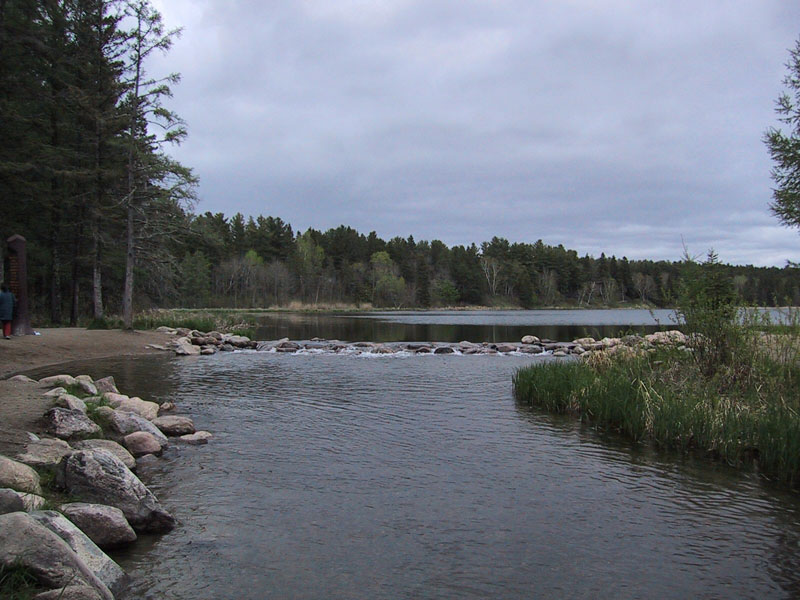
The source of the Mississippi River on the edge of Lake Itasca Location Itasca State Park, Clearwater County, Minnesota, USA Coordinates 47°13′05″N 95°12′26″W / 47.21806°N 95.20722°WCoordinates: 47°13′05″N 95°12′26″W / 47.21806°N 95.20722°W Lake type Glacial Primary inflows Nicollet Creek, Elk Lake outlet stream Primary outflows Mississippi River Basin countries United States Surface area 1.8 sq mi (4.7 km2) Average depth 20-35 ft (6-11 m) Surface elevation 1,475 ft (450 m) Islands Schoolcraft Island Lake Itasca is a small glacial lake, approximately 1.8 square miles (4.7 km2) in area, in the Headwaters area of north central Minnesota. The lake is located in southeastern Clearwater County within Itasca State Park and it has an average depth of 20–35 feet (6–11 m), and is 1,475 ft (450 m) above sea level.
The Ojibwe name for "Lake Itasca" was Omashkoozo-zaaga'igan (Elk Lake)[1]; this was changed by Henry Schoolcraft to "Itasca"[4], coined from a combination of the Latin words veritas ("truth") and caput ("head").[2][3] It is one of several examples of pseudo-Indian place names created by Schoolcraft.
Contents
Source of the Mississippi River
It is the source[4] of the Mississippi River which flows 2,340 mi (3,770 km) to the Gulf of Mexico; however, the exact point cannot be located, because there are many small tributaries and marshy areas that drain into the Mississippi watershed. Henry Schoolcraft identified Lake Itasca as the river's source in 1832. He had been part of a previous expedition in 1820 led by General Lewis Cass that had named nearby Cass Lake (which is downstream from Itasca) as the source of the river.
The western arm of the lake is fed by two small streams on its south end. Nicollet Creek, which is considered too small to be the headwaters, starts in a nearby spring. Another small stream leads into Itasca from Elk Lake,[Note 1] which in turn is fed by two other streams. The Ojibwa called Elk Lake and the stream Bekegamaag-zaaga'igan and Bekegamaag-ziibi (Sidelake Lake and Sidelake River), respectively.[1] In 1887 Williard Glazier promoted a campaign to consider Elk Lake, which he called Glazier Lake, as the true source of the Mississippi. These streams, however, are generally considered too small to be categorized as the headwaters of the river.
The decision was made by Jacob V. Brower, a land surveyor and president of the Minnesota Historical Society, who after spending five months exploring the lakes ruled that the lakes and streams further south of Lake Itasca were not the true source of the Mississippi. Brower was to campaign aggressively to save the lake from logging. On April 21, 1891, the Minnesota Legislature officially made it a state park by a margin of one vote. Brower is now called the "Father of Lake Itasca" and the visitor center is named in his honor.
The channel of the Mississippi as it emerges from the lake was moved in the 1930s by the Civilian Conservation Corps, to create a more pleasant experience for visitors. The project included the draining of the surrounding swamp, the digging of a new channel, and the installation of a man-made rock rapids. Wading across the rapids in bare feet is a popular recreational activity for summer tourists.
Uses
 Lake Itasca and Elk Lake
The lake is home to the University of Minnesota's Itasca Biological Station and Laboratories campus, which offers summer courses and field research work year round. The campus was established in 1909[5] and is composed of cabins for the students and faculty, laboratories, classrooms, offices, a computer lab, and dining and recreational facilities. The campus also has WIFI in several buildings and within the cabins. The current head of the biological station is Dr. John Biesbor.
When it was founded the Lake Itasca region was able to boast that it was the juncture of the three great habitats of North America. The Great Plains, the Deciduous Forest of the south, and the Coniferous Forest of the north. To this day, remnants of all three may be observed in the park.
Interestingly, the unique geography of the Lake Itasca region has even found its way onto the classical music concert stage. Composer Ferde Grofe depicted the birthplace of the Mississippi River and the Native Americans who reside there in his popular classical epic the Mississippi Suite.
See also
- List of Minnesota lakes
Notes
- ^ See the article on Julius Chambers on the discovery of Elk Lake.
References
- ^ a b Gilfillan, Joseph A. "Minnesota Geographical Names Derived from the Chippewa Language" in The Geological and Natural History Survey of Minnesota: The Fifteenth Annual Report for the Year 1886 (St. Paul: Pioneer Press Company, 1887)
- ^ Bright, William (2004). Native American Placenames of the United States. Norman: University of Oklahoma Press, pg. 188
- ^ Upham, Warren. "Minnesota Place Names: A Geographical Encyclopedia". Minnesota Historical Society. http://mnplaces.mnhs.org/upham/waterway.cfm?PlaceNameID=1481&BookCodeID=30&County=31&SendingPage=Results.cfm. Retrieved 2007-08-14.
- ^ The United States Geological Survey recognizes two contrasting definitions of a river's source.[1] By the stricter definition, the Mississippi would share its source with its longest tributary, the Missouri, at Brower's Spring in Montana. The other definition acknowledges "somewhat arbitrary decisions" and places the Mississippi's source at Lake Itasca, which is publicly accepted as the source,[2] and which had been identified as such by Brower himself.[3]
- ^ Upham, Warren. "Minnesota Place Names: A Geographical Encyclopedia". Itasca Biological Station and Laboratories About. http://www.cbs.umn.edu/itasca/about/. Retrieved 2010-07-11.
External links
Categories:- Geography of Clearwater County, Minnesota
- Lakes of Minnesota
- Mississippi River
- Civilian Conservation Corps in Minnesota
- Glacial lakes of the United States
![[4]](http://www.pgdp.net/c/tools/project_manager/displayimage.php?project=projectID45d7c990c6295&imagefile=243.png&showreturnlink=1&preload=prev&percent=100&jumpto=244.png)
Wikimedia Foundation. 2010.