- Pacific Coast Ranges
-
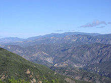
 Malibu Canyon, Santa Monica Mountains
The Pacific Coast Ranges (in Canada) [1] and the Pacific Mountain System (in the United States) [2] are the series of mountain ranges that stretch along the West Coast of North America from Alaska south to Northern and Central Mexico. Both the Canadian and United States portions are often referred to as Pacific Coast Ranges.[3]
The Pacific Coast Ranges are part of the North American Cordillera (sometimes known as the Western Cordillera, or in Canada, as the Pacific Cordillera and/or the Canadian Cordillera), which includes the Rocky Mountains, Columbia Mountains, Interior Mountains, the Interior Plateau, Sierra Nevada Mountains, the Great Basin mountain ranges, and other ranges and various plateaus and basins.
The Pacific Coast Ranges designation, however, only applies to the Western System of the Western Cordillera,[1] which comprises the Saint Elias Mountains, Coast Mountains, Insular Mountains, Olympic Mountains, Cascade Range, Oregon Coast Range, California Coast Ranges, Transverse Ranges, Peninsular Ranges, and the Sierra Nevada Mountains.
Contents
Other uses
The term Coast Range is used by the United States Geological Survey to refer only to the ranges south from the Strait of Juan de Fuca in Washington to the California-Mexico border; and only the ranges west of Puget Sound, the Willamette valley, the Sacramento and San Joaquin valleys or 'California Central Valley' (thereby excluding the Sierra Nevada and Cascade Ranges), and the Mojave (High) and Sonoran (Low) Deserts.[4] i.e. the Pacific Border province. The same term is used informally in Canada to refer to the Coast Mountains and adjoining inland ranges such as the Hazelton Mountains, and sometimes also the (Saint Elias Mountains)
Geography
The character of the ranges varies considerably, from the record-setting tidewater glaciers in the ranges of Alaska, to the rugged Central and Southern California ranges, the Transverse Ranges and Peninsular Ranges, in the chaparral and woodlands ecoregion with Oak Woodland, Chaparral shrub forest or Coastal sage scrub-covering them. The coastline is often dropping steeply into the sea with photogenic views. Along the British Columbia and Alaska coast, the mountains intermix with the sea in a complex maze of fjords, with thousands of islands. Off the Southern California coast the Channel Islands archipelago of the Santa Monica Mountains extends for 160 miles.
There are coastal plains at the mouths of rivers that have punched through the mountains spreading sediments, most notably at the Copper River in Alaska, the Fraser River in British Columbia, and the Columbia River between Washington and Oregon. In California: the Sacramento and San Joaquin Rivers' San Francisco Bay, the Santa Clara River's Oxnard Plain (home to some of the most fertile soil in the world), the Los Angeles, San Gabriel, and Santa Ana Rivers' Los Angeles Basin - a coastal sediment-filled plain between the peninsular and transverse ranges with sediment in the basin up to 6 miles (10 km) deep, and the San Diego River's Mission Bay.
From the vicinity of San Francisco Bay north, it is common in winter for cool unstable air masses from the Gulf of Alaska to make landfall in one of the Coast Ranges, resulting in heavy precipitation, both as rain and snow, especially on their western slopes. The same Winter weather occurs with less frequency and precipitation in Southern California, with the mountains' western faces and peaks causing an eastward rainshadow that produces the arid desert regions.
Omitted from the list below, but often included is the Sierra Nevada, a major mountain range of eastern California that is separated by the Central Valley over much of its length from the California Coast Ranges and the Transverse Ranges.[5]
Major ranges
These are the members of the Pacific Coast Ranges, from north to south:
- Kenai Mountains, southern Alaska
- Chugach Mountains, southern Alaska
- Talkeetna Mountains, southern Alaska
 Kenai Mountains
- Yukon Ranges, Alaska, Yukon
- Wrangell Mountains, southern Alaska
- Saint Elias Mountains, southern Alaska, southwestern Yukon, far northwestern British Columbia
- Alsek Ranges
- Fairweather Range
- Takshanuk Mountains, Haines, Alaska-area. Between Chilkat and Chilkoot watersheds
- Alsek Ranges
- Coast Mountains
- Boundary Ranges, southeastern Alaska, northwestern British Columbia
- Cheja Range (southeast of Taku/Whiting Rivers)
- Chechidla Range
- Chutine Icefield
- Adam Mountains
- Ashington Range
- Burniston Range
- Dezadeash Range
- Florence Range
- Halleck Range
 Juneau Icefield
 - Juneau Icefield
- Kakuhan Range
- Lincoln Mountains
- Longview Range
- Peabody Mountains
- Rousseau Range
- Seward Mountains
- Snowslide Range
- Spectrum Range
- Stikine Icecap
- Kitimat Ranges BC North Coast
- Pacific Ranges BC South & Central Coast
- Rainbow Range northwest Chilcotin, also classifiable as part of the Interior Plateau
 Rainbow Ridge
 - Pantheon Range Homathko area
- Niut Range Homathko area
- Waddington Range Homathko area
- Whitemantle Range Homathko area
- Bendor Range
- Garibaldi Ranges
- Clendinning Range
- Tantalus Range
- Chilcotin Ranges
- Lillooet Ranges, (Fraser Canyon west bank)'
- Douglas Ranges
- Front Ranges (North Shore Mountains)
- Rainbow Range northwest Chilcotin, also classifiable as part of the Interior Plateau
- Boundary Ranges, southeastern Alaska, northwestern British Columbia
- Insular Mountains, British Columbia
- Vancouver Island Ranges, British Columbia
- Queen Charlotte Mountains, British Columbia
 Mt. Constance, Olympic Mountains
- Olympic Mountains, Washington
- Cascade Range, British Columbia (Fraser Canyon west bank), Washington, Oregon and California
- Oregon Coast Range, Oregon
- Calapooya Mountains, Oregon
- Klamath-Siskiyou, Oregon, Northern California
- Klamath Mountains, Oregon, Northern California
- Siskiyou Mountains, Oregon, Northern California
- Trinity Alps and Salmon Mountains, Northern California
- Yolla Bolly Mountains, Northern California
- Northern Coast Ranges, Northern California
- King Range, Northern California
- Mendocino Range, Northern California
 Klamath Mountains
 - Mayacamas Mountains, Northern California
- Marin Hills, Northern California, (including Mount Tamalpais)
- Central California Coast Ranges, Central California
- Santa Cruz Mountains, Central California
- Diablo Range, Central California
- Santa Lucia Range, Central California
- Temblor Range, Central California
- Caliente Range, Central California
- Transverse Ranges, Southern California
- Sierra Madre Mountains, Southern California
- Sierra Pelona Mountains, Southern California
 San Rafael Mountains
 - San Emigdio Mountains, Southern California
- San Rafael Mountains, Southern California
- Santa Ynez Mountains, Southern California
- Tehachapi Mountains, Southern California
- Topatopa Mountains, Southern California
- Santa Susana Mountains, Southern California
- Simi Hills, Southern California
- Santa Monica Mountains, Southern California
- Chalk Hills, Southern California
- San Gabriel Mountains, Southern California
 Puente Hills
 - San Rafael Hills, Southern California
- Puente Hills, Southern California
- San Bernardino Mountains, Southern California
- Little San Bernardino Mountains, Southern California
- Peninsular Ranges, Southern California and Mexico
- Santa Ana Mountains, Southern California
- Chino Hills, Southern California
- San Jacinto Mountains, Southern California
- Palomar Mountain Range, Southern California
- Laguna Mountains, Southern California
- Sierra Juarez, Northern Baja California, Mexico
- Sierra San Pedro Martir, Central Baja California, Mexico
- Sierra de la Giganta, Southern Baja California, Mexico
- Sierra de la Laguna, Southern Baja California, Mexico
- Sierra Madre Occidental, Northwestern Mexico
Major icefields
These are not named as ranges, but amount to the same thing. The Pacific Coast Ranges are home to the largest temperate-latitude icefields in the world.
- Harding Icefield
- Sargent Icefield
 Harding Icefield
 - Bagley Icefield
- Kluane Icefields
- Juneau Icefield
- Stikine Icecap
- Ha-Iltzuk Icefield (Silverthrone Glacier)
- Monarch Icefield
- Waddington Icefield
- Homathko Icefield
- Lillooet Icecap (Lillooet Crown)
- Pemberton Icefield
Only the largest icefields are listed above; smaller icefields may be listed on the various range pages. Formally unnamed icefields are not listed
See also
- Category: Pacific Coast Ranges
- Coast Range (ecoregion)
- California Coast Ranges (geomorphic province)
- United States physiographic regions
References
- ^ a b S. Holland, Landforms of British Columbia, BC Govt. 1976.
- ^ Physiographic regions of the United States, USGS
- ^ Merriam-Webster's collegiate encyclopedia, page 361 (Merriam-Webster, 2000).
- ^ "Coast Ranges". Geographic Names Information System, U.S. Geological Survey. http://geonames.usgs.gov/pls/gnispublic/f?p=gnispq:3:::NO::P3_FID:252293. Retrieved 2007-07-30.
- ^ "Pacific mountain system". Britannica Online Encyclopedia. Encyclopædia Britannica. http://www.britannica.com/eb/article-9110721/Pacific-mountain-system. Retrieved 2007-09-29.
Categories:- Pacific Coast Ranges
- Geography of North America
- Geology of North America
- Physiographic provinces
- Physiographic regions of the United States
- Mountain ranges of the Western United States
- Mountain ranges of British Columbia
- Mountain ranges of Mexico
- Mountain ranges of Alaska
- Mountain ranges of California
- Mountain ranges of Oregon
- Mountain ranges of Washington (state)
- Geography of Baja California
- Natural history of Baja California Sur


Wikimedia Foundation. 2010.