- PAVE PAWS
-
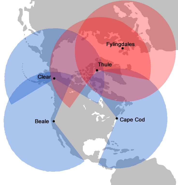
 Coverage of PAVE PAWS is shown in blue. This complements the coverage provided by the BMEWS system in red. Both report back to Cheyenne Mountain Air Base in Colorado.
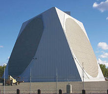 The PAVE PAWS Radar at Clear AFS, Alaska
PAVE PAWS is a United States Air Force Space Command radar system operated by three 21st Space Wing squadrons for missile warning and space surveillance. Operational PAVE PAWS radars are located at:[1]
- Cape Cod Air Force Station, Massachusetts. Operated by 6th Space Warning Squadron, (41°45′08″N 70°32′17″W / 41.75222°N 70.53806°W)
- Beale AFB, California. Operated by 7th Space Warning Squadron, (39°08′10″N 121°21′03″W / 39.13611°N 121.35083°W)
- Clear Air Force Station, Alaska. Operated by 13th Space Warning Squadron, (64°18′01″N 149°11′23″W / 64.30028°N 149.18972°W). Scheduled to become a PAVE PAWS site from being a BMEWS site in 2001.[2]
In addition, two other facilities were shuttered by the Air Force in 1995: Robins Air Force Base, Warner Robins, Georgia (32°34′52″N 83°34′09″W / 32.58111°N 83.56917°W), and Eldorado AFS, Texas (30°58′44″N 100°33′14″W / 30.979°N 100.554°W).
PAVE is an Air Force program name, while PAWS stands for Phased Array Warning System.[1] PAVE has also been defined as an acronym for Precision Acquisition Vehicle Entry, but that is likely a backronym created to explain the program name.[citation needed] The radar, developed by Raytheon, is used primarily to detect and track sea-launched (SLBM) and intercontinental ballistic missiles (ICBMs).
The system also has a secondary mission of detecting and tracking Earth-orbiting satellites. Information received from the PAVE PAWS radar systems pertaining to SLBM/ICBM and satellite detection is forwarded to the U.S. Strategic Command’s Missile Correlation (formerly Missile Warning) and Space Control Centers at Cheyenne Mountain Air Station, Colorado. Data is also sent to the National Military Command Center and to U.S. Strategic Command's Command Center at Offutt AFB, Nebraska.
Contents
Features
 A Radar screen for the PAVE PAWS at Cape Cod AFS, 1986.
An aspect of this radar is phased array antenna technology which is now common in defence applications. This system differs from a mechanical radar, which must be physically aimed at an object in space to detect and/or track it. The phased array antenna is in a fixed position and can be part of the building wall. Phased array antenna aiming, or beam steering, is done rapidly by electronically controlling the timing (the phase) of the incoming and outgoing signals. Controlling the phase through the many segments of the antenna system allows the beam to be quickly projected in different directions. This greatly reduces the time necessary to change the beam direction from one point to another, allowing almost simultaneous tracking of multiple targets while maintaining the surveillance responsibility. This ability is known as "track while scan". The large fixed antenna array through its better beam focusing, improves system sensitivity and tracking accuracy.
Phased array radars are also commonly found on U.S. Navy ships (the Aegis system), and in the U.S. Army's Patriot air defense missile system.
Background
 A Computer room for PAVE PAWS at Cape Cod AFS, 1986. Note the four large hard disk units in the foreground.
- Section source: Fact Sheet[1]
A phased array antenna, as with any other directional antenna, will receive signals from space only in the direction in which the beam is aimed. The maximum practical deflection on either side of antenna center of the phased array beam is 60 degrees. This limits the coverage from a single antenna face to 120 degrees. To provide surveillance across the horizon, the building housing the entire system and supporting the antenna arrays is constructed in the shape of a triangle. The two building faces supporting the arrays, each covering 120 degrees, will monitor 240 degrees of azimuth. The array faces are also tilted back 20 degrees to allow for an elevations deflection from three to 85 degrees above horizontal. The radar system is capable of detecting and monitoring a great number of targets that would be consistent with a massive SLBM attack. The system must rapidly discriminate between vehicle types, calculating their launch and impact points in addition to the scheduling, data processing and communications requirements. The operation is entirely automatic, requiring people only for monitoring, maintenance and as a final check of the validity of warnings. Three different computers communicate with each other from the heart of the system, which relays the information to Cheyenne Mountain AS.
Environmental and health concerns
The PAVE PAWS radar station in Massachusetts has been investigated as a possible source for health concerns on Cape Cod. General studies have found that there is no elevated cancer risk from the station.[3] However, it was recently cited as a possible cause of elevated Ewing's Sarcoma rates on the Cape.[4] According to the National Academies' National Research Council, in 2005 available data did not support those concerns.[5] According to a local news broadcast, "Two years ago, [the academy study] concluded that PAVE PAWS was probably not to blame for elevated cancer rates in the general population. But that study did not address Ewing’s sarcoma." The Massachusetts state Department of Public Health conducted an investigation into specific incidences of the cancer on Cape Cod and their possible relationship to the PAVE PAWS radar station. The state hired a company to test the levels of radiation received on certain Cape Cod streets in order to look for correlations in peak power levels in local communities with incidence of the cancer. According to the father of one of patient, "All of [the affected children mentioned in the broadcast] occupied places for a significant amount of time that received a high level of radiation from PAVE PAWS,"[6] though there is currently no published research verifying the claim and the final report indicated that levels were not high. In December 2007, the Massachusetts Department of Health released their report which concluded that it "appears unlikely that PAVE PAWS played a primary role in the incidence of Ewing family of tumors on Cape Cod."[7]
An Air Force Medical Study conducted in 2005 included radiation density measurements at the facility and concluded power densities outside the 15 metres (49.2 ft) roped off area in front of the array were within the controlled permissible exposure limits in place. According to the report, no hazard exists to personnel outside of the roped off area per set standards.[8]
See also
- Nuclear weapons and the United States
- Ballistic Missile Early Warning System
- Missile Defense Alarm System
- Defense Support Program
- United States Space Surveillance Network
- Specific US radar and locations
- Cobra Dane, Eareckson Air Station, Alaska
- Thule Air Base, Greenland
- Clear Air Force Station, Alaska
- RAF Fylingdales, United Kingdom
- Cape Cod Air Force Station, Otis Air National Guard Base, Massachusetts
- Beale Air Force Base, California
- Eglin Air Force Base, Florida
- Cavalier Air Force Station, North Dakota
- "Texas Towers" North Atlantic offshore radar platforms
References
- ^ a b c USAF PAVE PAWS Fact Sheet Accessed 17 July 2007
- ^ FAS.ORG PAVE PAWS Site
- ^ Cape radar found not to pose health risk Accessed 05 November 2007[dead link]
- ^ CBS4 Boston (WBZ-TV) 11pm news broadcast. 05 November 2007
- ^ National Academies' National Research Council. Available Data Do Not Show Health Hazard to Cape Cod Residents From Air Force PAVE PAWS Radar. January 2005.
- ^ "State Seeks Cause For Cape Cancer Cases". WBZ-TV (CBS affiliate). 5 November 2007. http://wbztv.com/health/local_story_309225533.html. Retrieved 2007-11-05.[dead link]
- ^ Massachusetts Department of Health. Evaluation of the Incidence of the Ewing's Family of Tumors on Cape Cod, Massachusetts and the PAVE PAWS Radar Station - December 2007. (PDF)
- ^ 2005 Radio Frequency Power Density Survey for the Precision Acquisition Vehicle Entry-Phased Array Warning System (PAVE PAWS), Cape Cod AFS, MA
External links
- GlobalSecurity.org (with images)
- AN/FPS-115, AN/FPS-120, AN/FPS-123, AN/FPS-126
- Ham Radio Users Forced to Make Way for PAVE PAWS
Categories:- Radar networks
- Raytheon products
- Equipment of the United States Air Force
- Joint Electronics Type Designation System


Wikimedia Foundation. 2010.