- Main-Tauber-Kreis
-
Main-Tauber — District — 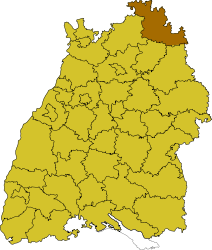
Country  Germany
State Baden-Württemberg Adm. region Stuttgart Capital Tauberbischofsheim Area – Total 1,304.51 km2 (503.7 sq mi) Population (31 December 2010)[1] – Total 133,351 – Density 102.2/km2 (264.8/sq mi) Time zone CET (UTC+1) – Summer (DST) CEST (UTC+2) Vehicle registration TBB Website http://www.main-tauber-kreis.de Main-Tauber-Kreis is a district (Kreis) in the north-east of Baden-Württemberg, Germany. Neighboring districts are (from north-west clockwise) Miltenberg, Main-Spessart, Würzburg, Neustadt (Aisch)-Bad Windsheim and Ansbach (all in Bavaria), and the districts of Schwäbisch Hall, Hohenlohe and Neckar-Odenwald.
Contents
History
The district was created in 1973 by merging the districts of Bad Mergentheim, Tauberbischofsheim and parts of the district of Buchen. At first it was called the district of Tauber, but in 1974 it was renamed to its current name, the district of Main-Tauber. The name comes from the two primary rivers in the district, the Main and the Tauber.
Geography
The Main forms the northern border of the district, while its affluent Tauber flows through the district from southeast to north. The north of the district covers part of the Spessart mountains, while the southern area is called Bauland.
Coat of arms

The coat of arms show the symbols of the three historical states to which the area of the district belonged. The biggest part of the district was part of the Bishopric of Würzburg until 1803; Würzburg is represented by the red and white field divided by a line with three peaks, which was originally the coat of arms of Franconia. The wheel is the symbol of the Archbishopric of Mainz; the cross is the symbol of the Teutonic Order. Cities and municipalities
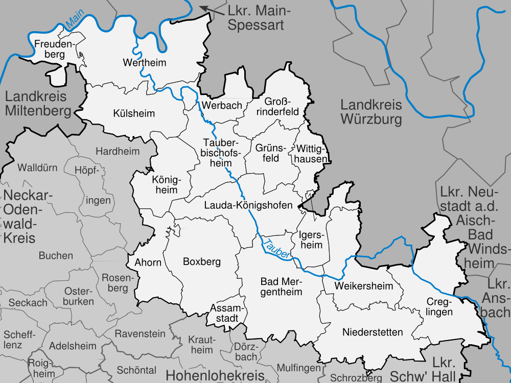
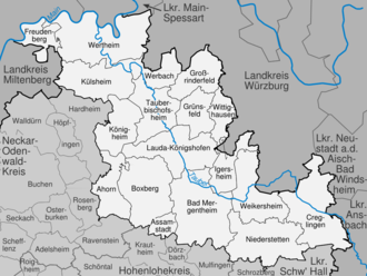 cities and towns in the district of Main-Tauber
Cities Administrative districts Municipalities - Bad Mergentheim
- Boxberg
- Grünsfeld
- Tauberbischofsheim
References
- ^ "Bevölkerung und Erwerbstätigkeit" (in German). Statistisches Landesamt Baden-Württemberg. 31 December 2009. http://www.statistik-bw.de/Veroeffentl/Statistische_Berichte/3126_10001.pdf.
External links
- Official website (German)
 Regions, and urban and rural districts in the state of Baden-Württemberg in Germany
Regions Urban districts Rural districts - Alb-Donau
- Biberach
- Bodensee
- Böblingen
- Breisgau-Hochschwarzwald
- Calw
- Emmendingen
- Enz
- Esslingen
- Freudenstadt
- Göppingen
- Heidenheim
- Heilbronn
- Hohenlohe
- Karlsruhe
- Konstanz
- Lörrach
- Ludwigsburg
- Main-Tauber
- Neckar-Odenwald
- Ortenau
- Ostalbkreis
- Rastatt
- Ravensburg
- Rems-Murr
- Reutlingen
- Rhein-Neckar
- Rottweil
- Schwarzwald-Baar
- Schwäbisch Hall
- Sigmaringen
- Tübingen
- Tuttlingen
- Waldshut
- Zollernalb
Categories:- Districts of Baden-Württemberg
- Stuttgart region

Wikimedia Foundation. 2010.