Mossbrae Falls

Mossbrae Falls

Coordinates: 41°14′30″N 122°16′01″W / 41.24167°N 122.26694°W / 41.24167; -122.26694

Mossbrae Falls, California

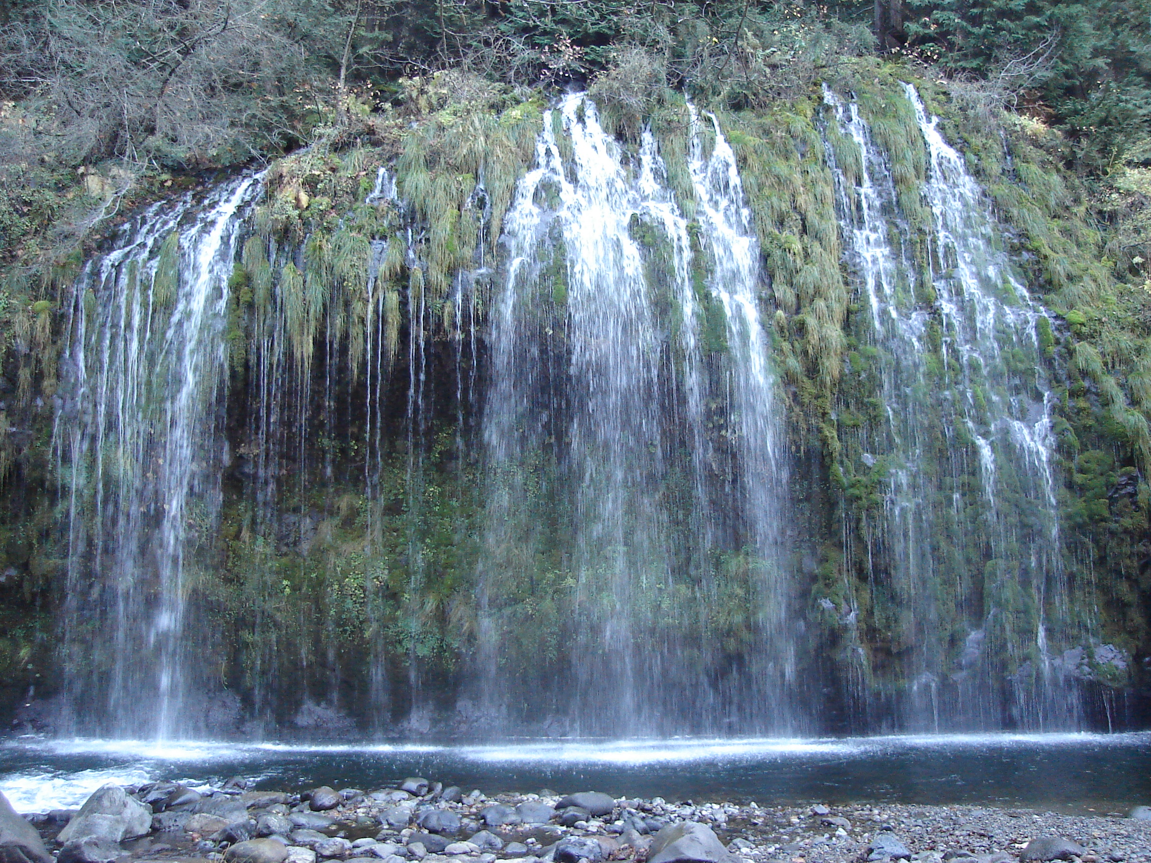
Mossbrae Falls is a waterfall flowing into the Sacramento River, in the Shasta Cascade area in Dunsmuir, California. The falls are accessible via a mile-long hiking trail along the Union Pacific Railroad, which begins at the Shasta Retreat on Scarlett Way in Dunsmuir.[1]

Mossbrae Falls is one of the more scenic waterfalls in California. Approximately 50 ft (15 m) in height and150 ft (46 m) wide, the falls are fed by springs, which course down the canyon wall, and into the Sacramento River, creating the effect of many waterfall streams falling into the river. The entire course of the falls is longer than 50 ft (15 m), however the upper cascades cannot be observed through flora which covers the mountainside. The bottom 50 ft (15 m) is a straight plunge into the river.

The trail to the falls follows beside the Union Pacific railroad tracks, and is narrow in some places. The waterfall is to the right, immediately before a nearby railroad bridge.

References


Wikimedia Foundation. 2010.

Игры ⚽ Нужно решить контрольную?

Look at other dictionaries:

  • Dunsmuir, California — City of Dunsmuir   City   Location in Sis …   Wikipedia

  • Dunsmuir Botanical Gardens — is a 10 acre botanical garden maintained by Dunsmuir Botanical Gardens Inc., a non profit 501(c)(3)organization of volunteers within Dunsmuir City Park in the city of Dunsmuir, California near Mount Shasta. It requires public support to maintain… …   Wikipedia

  • Siskiyou County, California — County of Siskiyou   County   Mount Shasta presides over much of Siskiyou County …   Wikipedia

  • McCloud, California — McCloud   census designated place   Lo …   Wikipedia

  • Weed, California — Infobox Settlement official name = Weed, California other name = native name = nickname = settlement type = City motto = imagesize = image caption = flag size = image seal size = image shield = shield size = image blank emblem = blank emblem type …   Wikipedia

  • Yreka, California — Infobox Settlement official name = Yreka other name = native name = nickname = settlement type = City motto = imagesize = 250x200px image caption = Statue at entrance to Yreka Historic District flag size = image seal size = image shield = shield… …   Wikipedia

  • Shasta Cascade — The Shasta Cascade region of California is located in the northeastern and north central sections of the state bordering Oregon and Nevada, including far northern parts of the Central Valley and the Sierra Nevada mountain range. The area is… …   Wikipedia

  • Mount Shasta, California — This article is about the city. For the community in Shasta County, California, see Shasta, California. For the mountain, see Mount Shasta. City of Mount Shasta   City   …   Wikipedia

  • Castella, California — Castella is a small, unincorporated town of 240 in the upper Sacramento Canyon of Shasta County, California. It is located 46 miles north of Redding on Interstate 5, and is home to Castle Crags State Park. It has a Chevron gas station/store and a …   Wikipedia

Share the article and excerpts

Direct link
Do a right-click on the link above
and select “Copy Link”