- Craigellachie, British Columbia
-
Craigellachie 
Coordinates: 50°58′31″N 118°43′25″W / 50.97528°N 118.72361°W Country  Canada
Province  British Columbia
Region BC Interior Regional district Columbia-Shuswap Regional District Land District Kamloops Division Yale Land District Time zone PST (UTC−8) - Summer (DST) PDT (UTC−7) Postal code span V0E 2J0 Highways Trans-Canada Highway Craigellachie (pronounced /krəˈɡɛləxi/, but /k/ or /h/ can be substituted for the /x/) is a locality in British Columbia, located several kilometres to the west of the Eagle Pass summit between Sicamous and Revelstoke.[1] Craigellachie is the site of a tourist stop on the Trans-Canada Highway between Salmon Arm and Revelstoke.
It was named after the village of Craigellachie on the River Spey in Moray, Scotland, the ancestral home of Sir George Stephen, the first president of the Canadian Pacific Railway (CPR). At a critical time in the railway's development, Stephen travelled to Britain to raise desperately needed capital funding; when he succeeded, he telegraphed his associates in Canada quoting the familiar motto of Clan Grant: "Stand fast, Craigellachie!"
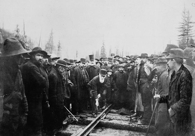
 Sir Donald Smith drives in the last spike at Craigellachie
The Canadian Craigellachie is most famous for being the site of the "Last Spike" of the CPR, driven by Sir Donald Smith, a director of the CPR, on November 7, 1885.[2]
References
- ^ "Craigellachie (community)". BC Geographical Names. http://apps.gov.bc.ca/pub/bcgnws/names/4772.html.
- ^ In actual fact, Sir Donald drove in two spikes; his first attempt resulted in a bent spike and so the Last Spike was a replacement.
Subdivisions of British ColumbiaSubdivisions Regions · Regional districts · Forest Regions and Forest Districts · School districts · Land DistrictsSettlements Urban centres  Category:British Columbia ·
  Portal:British Columbia ·
  WikiProject:British Columbia
Coordinates: 50°58′31″N 118°43′25″W / 50.97528°N 118.72361°W
Categories:- Unincorporated settlements in British Columbia
- Shuswap Country
- Columbia Country
- Canadian Pacific Railway stations in British Columbia
- Populated places in the Columbia-Shuswap Regional District
Wikimedia Foundation. 2010.