Cape Schanck Lighthouse

Cape Schanck Lighthouse

Infobox_lighthouse
name=Cape Schanck
location= Mornington Peninsula, Victoria, Australia
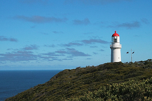


caption=
coordinates = coord|38.49|S|144.89|E
yearlit= 1859
yeardeactivated=
automated=
intensity= 1,000,000 CD
elevation= 100 metres
range= convert|26|nmi|km|0
foundation=
construction= Limestone
shape=Conical
height= 21 meters
lens=
currentlens=1st order Fresnel by Chance Brothers
characteristic=Mo (N)
marking=White with red lantern dome
admiralty=K2423
NGA=7456
ARLHS=AUS-045

The Cape Schanck lighthouse was built in 1859 as the second lighthouse in Victoria. It is located on the southernmost tip of the Mornington Peninsula in Victoria, Australia. The tower was built from limestone, it is 21 metres tall. The light's focal plane is situated 100 metres above sea level, the light characteristic is the Morse Code letter "N", a long signal of 10.8 seconds followed by a flash. Depending on the bearing of the light, the colours are either white (south to west sector) or red (east sector). Due to its powerful lantern of one million candela and a first order Fresnel lens, which was installed in 1915, the light has a range of 26 nautical miles.

The lighthouse was not only one of the first such buildings in Victoria, it was moreover Australia's first lighthouse tower with stone stairs. During the 1970s and 1980s the facility was restored and has since become an attraction for tourists.

References

*cite web|url=http://www.unc.edu/~rowlett/lighthouse/vic.htm|author=Rowlett, Russ|title=The Lighthouse Directory


Wikimedia Foundation. 2010.

Игры ⚽ Нужно решить контрольную?

Look at other dictionaries:

  • Cape Schanck, Victoria — Infobox Australian Place | type = town name = Cape Schanck state = vic caption = Cape Schanck (view from atop the lighthouse) lga = Shire of Mornington Peninsula postcode = 3939 pop = 334 (2006)Census 2006 AUS | id = SSC25303 | name = Cape… …   Wikipedia

  • Cliffy Island Lighthouse — Cliffy Island Lighthouse, 1917 Location Bass Strait, 17 nmi S of Port Albert, Victoria, Australia Coordinates …   Wikipedia

  • Liste australischer Leuchttürme und Feuerschiffe — Diese Liste enthält Leuchttürme und Feuerschiffe in Australien. An der 25.760 km langen Küstenlinie Australiens[1] befinden sich über 350 Leuchttürme und Navigationshilfen[2] und im Inland gibt es den Point Malcolm Leuchtturm, den einzigen… …   Deutsch Wikipedia

  • Parks Victoria — est une agence gouvernementale de l État du Victoria. Elle fut mise en place en décembre 1996, et, en tant qu autorité de service public, elle rend compte au ministre de l Environnement et du Changement climatique. La loi de 1998 rend Parks… …   Wikipédia en Français

  • Parks Victoria — is a government agency of the state of Victoria, Australia. It was established in December 1996 and, as a statutory authority, it reports to the Minister for Environment and Climate Change. The Parks Victoria Act 1998 makes Parks Victoria… …   Wikipedia

  • Citadel Island — Lighthouse Location Bass Strait, 13 km SW of Tidal River, Wilsons Promontory, Australia Coordinates 39°06′54″S 146°14′13″E /  …   Wikipedia

  • McCrae, Victoria — McCrae Melbourne, Victoria …   Wikipedia

Share the article and excerpts

Direct link
Do a right-click on the link above
and select “Copy Link”