- Red River Floodway
-
 Red River floodway at the southeast corner of the Winnipeg city limits near Lorette as seen from the air. The Trans Canada Highway and Canadian National Railway bridges over the floodway can be seen, along with the Perimeter Highway.
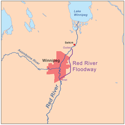
The Red River Floodway is an artificial flood control waterway in Western Canada, first used in 1969. It is a 47 km (29 mi) long channel which, during flood periods, takes part of the Red River's flow around the city of Winnipeg, Manitoba to the east and discharges it back into the Red River below the dam at Lockport. It can carry floodwater at a rate of up to 2,550 cubic metres (91,700 cubic feet) per second. It was built partly in response to the disastrous 1950 Red River flood.
The Floodway was pejoratively nicknamed "Duff's Ditch" by opponents of its construction, after Premier Duff Roblin, whose Progressive Conservative government initiated the project. It was completed in time and under budget. Subsequent events have vindicated the plan. Used over 20 times in the 37 years from its completion to 2006, the Floodway has saved an estimated $10 billion (CAD) in flood damages.
Contents
History
Construction of the Floodway started on October 6, 1962 and finished in March 1968. The construction was a major undertaking with 76.5 million cubic metres (2.75 billion cubic feet) of earth excavated—more than what was moved for the Suez Canal.[1] At the time, the project was the second largest earth-moving project in the world – next only to the construction of the Panama Canal.[2] The total cost at the time was $63 Million (CAD), equivalent to approximately $360 million today.
Design
 Control gates at the inlet to the Floodway
 Bridge over the control gates
The Floodway protection system includes more than just the channel to the east of the city, but also the dikes along the river through Winnipeg and the "Brunkild Z-dike" extending to the west from the south of the city. The Brunkild Dike was built in 1997 during the "Flood of the Century" when the volume of water exceeded the safe capacity of the Floodway and water lapped within inches of the city's dikes. Primarily as a result of the Floodway, the city suffered little flood damage.
The Brunkild dike is the limiting factor on the volume of water that can be diverted around the city, as a result of the extremely low grades in the area. In 2003, the province announced plans to expand the Floodway, increasing its flow capacity from 2,550 m3/s (90,000 cu ft/s) to 4,000 m3/s (140,000 cu ft/s). It was decided to widen the Floodway as opposed to deepening it because of the soil and ground conditions in the area. There are many underground aquifers in the area that are used for drinking water for rural residents which could potentially be contaminated if the floodway were any deeper. There is also potential for pressures to increase in the aquifers, causing a "blowout" to occur, where water would flow from the aquifers in the ground to the surface and reduce the capacity of the Floodway. Thus, it was decided widening the floodway would be the best option despite the lower hydraulic capacity that would result.
Expansion
Since the 1997 Red River Flood resulted in water levels that took the existing floodway to the limits of its capacity, various levels of government commissioned engineering studies for a major increase in flood protection for the City of Winnipeg. Work began in late 2005 under a provincial collective bargaining agreement and has included modifications to rail and road crossings as well as transmission line spans, upgrades to inlet control structures and fire protection, increased elevation of existing dikes (including the Brunkild dike), and the widening of the entire floodway channel itself. The NDP government set aside a portion of the construction budget just for aboriginal construction firms.[3] Completion of the Red River Floodway Expansion is slated for late 2010 at a final cost of more than $665,000,000 CAD. When the expansion is completed, the capacity of the floodway will increase to 4,000 cubic metres (140,000 cubic feet) per second, the estimated level of a 1-in-700 year flood event. (Using the flow rates of Niagara Falls as a standard of comparison, this is more than double its average of 1,833 cubic metres and about a third over its maximum.) The expanded floodway will protect over 140,000 homes, over 8,000 businesses, and prevent more than $12 billion (CAD) in damages to the provincial economy in the event of a 1-in-700 year flood.
Criticism
The NDP government was criticized by Conservatives for forcing construction companies to unionize. Brian Pallister told parliament, "the Manitoba NDP government is planning to proceed with a plan to force every worker on the Red River floodway expansion to unionize, despite the fact that 95% of Manitoba's construction companies are not unionized." [4]
Recognition
On July 4, 2008, the International Association of Macro Engineering Societies recognized the floodway as one of the 16 engineering achievements that shaped the world since biblical times.[1]
Considerations in the United States
In 2009, the North Dakota cities of Fargo and Grand Forks have been contemplating building their own small floodways, similar to the Red River Floodway.[5] This is in response to the disastrous floods of 1997 (nicknamed "The Flood of the Century"), and in early 2009.
See also
- Portage Diversion (Assiniboine River Floodway)
- Shellmouth Reservoir
Notes
- ^ a b “Floodway dubbed engineering marvel”, Martin Cash, Winnipeg Free Press, 2008-07-04.
- ^ “A Tribute to Roblin’s Vision”, Manitoba Floodway Authority, Province of Manitoba, last accessed on 2009-03-26.
- ^ http://www.dailycommercialnews.com/article/id27497
- ^ http://openparliament.ca/politicians/220/?page=17
- ^ Dakota cities may mimic Winnipeg floodway
External links
- Manitoba Floodway Authority
- A Review of the Red River Floodway Operating Rules - Manitoba Conservation
- Flood control works
- CBC Video Archives: Duff's Ditch is completed
Coordinates: 50°05′24″N 96°56′03″W / 50.090005°N 96.934079°W
Categories:- Buildings and structures in Manitoba
- Geography of Winnipeg
- Flood control projects
- Flood control in Canada
- Macro-engineering


Wikimedia Foundation. 2010.