- Geography of the Republic of the Congo
-
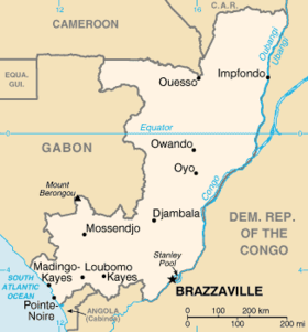
Coordinates: 1°00′S 15°00′E / 1°S 15°E The Republic of the Congo is located in the western part of Central Africa. Situated on the Equator, it is bordered by the Angola exclave of Cabinda to the south (201 km), the Democratic Republic of the Congo to the south and east (2,410 km), the Central African Republic (467 km) and Cameroon (523 km) to the north and Gabon to the west (1,903 km). Congo has a 169 km long Atlantic coast with several important ports. The Republic of the Congo covers an area of 342,000 km², of which 341,500 km² is land while 500 km² is water. Congo claims 200 nautical miles (370 km) of territorial sea.
 Topography of the Republic of the Congo.
The capital of the Republic of the Congo is Brazzaville, located on the Congo river immediately across from Kinshasa, capital of the Democratic Republic of the Congo. With a metropolitan population of approximately 1.5 million, Brazzaville is by far the largest city in the Republic, having almost twice the population of Pointe-Noire (663,400 as of the 2005 census), the country's second largest city. About 70% of the population lives in Brazzaville, Pointe-Noire, or along the railroad between them.

Contents
Environment
Climate
Congo is a tropical nation, which means it has a tropical climate. The wet season lasts from March to June and the dry season for the rest of the year. Temperature and humidity are high as in all tropical nations. The rivers of the country are flooded seasonally.
Ecology
The terrain is a variation of coastal plains, mountaineous regions, plateaus and fertile valleys. About 70 percent of the country's area is covered by rain forest. The highest point, at 1,020 m, is Mont Nabeba in the Mayumbe mountains. The major rivers are the Congo River at the border with the Democratic Republic of the Congo, and the Kouilou-Niari River.
Natural resources
Natural resources include petroleum, timber, potash, lead, zinc, uranium, copper, phosphates, natural gas, and hydropower. 1.45% of the land is arable, while only 0.15% contains permanent crops. Approximately 10 km² is irrigated (1993 estimation).
Environmental issues
Environmental issues include the high level of air pollution from vehicle emissions, water pollution from the dumping of raw sewage, tap water not being potable, and deforestation.
Congo is party to the international agreements on Biodiversity, Climate Change, Desertification, Endangered Species, Ozone Layer Protection, Tropical Timber 83, Tropical Timber 94, Wetlands. It has signed but not ratified the Law of the Sea.
Extreme points
This is a list of the extreme points of the Republic of Congo, the points that are farther north, south, east or west than any other location.
- Northern-most point - unnamed location on the border with Central African Republic immediately south-west of the CAR town of Madoukou, Likouala department
- Eastern-most point - Motenge-Bom, Likouala department
- Southern-most point - unnamed headland near the point at which the Congo-Cabinda border enters the Atlantic Ocean, Kouilou department
- Western-most point - the point at which the border with Gabon enters the Atlantic Ocean, Kouilou department
References
- "CIA - The World Factbook -- Congo, Republic of the". The World Factbook. Central Intelligence Agency. 2008. https://www.cia.gov/library/publications/the-world-factbook/geos/cf.html. Retrieved 2008-02-04.
Sovereign
states- Algeria
- Angola
- Benin
- Botswana
- Burkina Faso
- Burundi
- Cameroon
- Cape Verde
- Central African Republic
- Chad
- Comoros
- Democratic Republic of the Congo
- Republic of the Congo
- Côte d'Ivoire (Ivory Coast)
- Djibouti
- Egypt
- Equatorial Guinea
- Eritrea
- Ethiopia
- Gabon
- The Gambia
- Ghana
- Guinea
- Guinea-Bissau
- Kenya
- Lesotho
- Liberia
- Libya
- Madagascar
- Malawi
- Mali
- Mauritania
- Mauritius
- Morocco
- Mozambique
- Namibia
- Niger
- Nigeria
- Rwanda
- São Tomé and Príncipe
- Senegal
- Seychelles
- Sierra Leone
- Somalia
- South Africa
- South Sudan
- Sudan
- Swaziland
- Tanzania
- Togo
- Tunisia
- Uganda
- Zambia
- Zimbabwe
States with limited
recognition- Sahrawi Arab Democratic Republic
- Somaliland
Dependencies and
other territories- Canary Islands / Ceuta / Melilla / Plazas de soberanía (Spain)
- Madeira (Portugal)
- Mayotte / Réunion (France)
- Saint Helena / Ascension Island / Tristan da Cunha (United Kingdom)
- Western Sahara
Climate of Africa Sovereign
states- Algeria
- Angola
- Benin
- Botswana
- Burkina Faso
- Burundi
- Cameroon
- Cape Verde
- Central African Republic
- Chad
- Comoros
- Democratic Republic of the Congo
- Republic of the Congo
- Côte d'Ivoire (Ivory Coast)
- Djibouti
- Egypt
- Equatorial Guinea
- Eritrea
- Ethiopia
- Gabon
- The Gambia
- Ghana
- Guinea
- Guinea-Bissau
- Kenya
- Lesotho
- Liberia
- Libya
- Madagascar
- Malawi
- Mali
- Mauritania
- Mauritius
- Morocco
- Mozambique
- Namibia
- Niger
- Nigeria
- Rwanda
- São Tomé and Príncipe
- Senegal
- Seychelles
- Sierra Leone
- Somalia
- South Africa
- South Sudan
- Sudan
- Swaziland
- Tanzania
- Togo
- Tunisia
- Uganda
- Zambia
- Zimbabwe
States with limited
recognition- Sahrawi Arab Democratic Republic
- Somaliland
Dependencies and
other territories- Canary Islands / Ceuta / Melilla / Plazas de soberanía (Spain)
- Madeira (Portugal)
- Mayotte / Réunion (France)
- Saint Helena / Ascension Island / Tristan da Cunha (United Kingdom)
- Western Sahara
Categories:


Wikimedia Foundation. 2010.