Cordillera Central (Puerto Rico)
- Cordillera Central (Puerto Rico)
-

Cordillera Central from Mirador (Lookout) Villalba-Orocovis
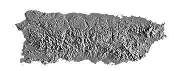
The Cordillera Central, or La Cordillera Central (The Central Mountain range), is the main mountain range in Puerto Rico. Generally speaking, the range crosses the island from west to east with an average elevation of 915m (about 3000 ft) and divides the territory's northern and southern coastal plains.
La Cordillera Central runs east to west from Aibonito to the outskirts of the Sierra de Cayey, which is an extension of La Cordillera Central beginning at the city of Cayey and which runs east to the city of Humacao with elevations approaching only 400 ft. (122m). It ends in a fork with two lower ranges, the Sierra Guardarraya and Cuchillas de Panduras which runs between the towns of Yabucoa and Patillas.
La Sierra De Luquillo branches northeastward from Gurabo to Fajardo and includes several high peaks - Toro Hill, at 1,074 m (3524 ft), El Yunque at 1,065m (3,494 ft) and El Pico Oeste at 1056 m (3446 ft).
Mountains in the range
The 50 Highest Mountain Peaks of Puerto Rico
| Rank |
Mountain Peak |
City/Town and Barrio |
Elevation |
| 1 |
Cerro Punta |
Jayuya (Yeguitas) |
1,338 m (4,390 ft) |
| 2 |
Monte Jayuya |
Jayuya (Saliente) |
1,315 m (4,314 ft) |
| 3 |
Cerro Rosa |
Jayuya (Saliente) |
1,267 m (4,157 ft) |
| 4 |
Tres Picachos |
Ciales and Jayuya (Coabey) |
1,205 m (3,953 ft) |
| 5 |
Monte Guilarte |
Adjuntas (Guilarte) |
1,204 m (3,950 ft) |
| 6 |
Cerro Maravilla |
Ponce |
1,160 m (3,806 ft) |
| 7 |
Las Tetas |
Cayey |
841 m (2,759 ft) |
External links
See also
Categories:
- Mountains of Puerto Rico
- Puerto Rico geography stubs
Wikimedia Foundation.
2010.
Look at other dictionaries:
Cordillera Central — The Cordillera Central, meaning central range in Spanish, is used to refer to several mountain ranges around the world: Cordillera Central, Andes (disambiguation), several mountain ranges in South America Cordillera Central, Colombia Cordillera… … Wikipedia
Puerto Rico — Puerto Rican. /pwer teuh ree koh, pwer toh, pawr teuh, pohr /; Sp. /pwerdd taw rddee kaw/ an island in the central West Indies: a commonwealth associated with the U.S. 3,196,520; 3435 sq. mi. (8895 sq. km). Cap.: San Juan. Formerly (until 1932),… … Universalium
National Register of Historic Places listings in central Puerto Rico — This portion of National Register of Historic Places listings in Puerto Rico is along the central mountain region, from Lares in the central west to Gurabo in the central east, including the slopes of the Cordillera. See also: National Register… … Wikipedia
Geography of Puerto Rico — Infobox Islands name = Puerto Rico image caption = Satellite photo of Puerto Rico image size = locator map custom = no native name = Borinquen native name link = Taino nickname = Isle of Enchantment Isla del Encanto location = Caribbean Sea… … Wikipedia
Cordillera Central — geographical name 1. range of the Andes in Colombia 2. range of the Andes in Peru E of the Marañón 3. chief range of the Dominican Republic 4. range Philippines in N Luzon see pulog (Mount) 5. range S central Puerto Rico see Cerro de Punta … New Collegiate Dictionary
Cordillera Central — /kawrdd dhee ye rddah sen trddahl / 1. a mountain range in Colombia: part of the Andes. Highest peak, Huila, 18,700 ft. (5700 m). 2. a mountain range in the Dominican Republic. Highest peak, Pico Duarte, 10,414 ft. (3174 m). 3. a mountain range… … Universalium
Cordillera Central — Cor•di•lle•ra Cen•tral [[t]ˌkɔr ðiˈyɛ rɑ sɛnˈtrɑl[/t]] n. 1) geg a mountain range in Colombia: part of the Andes. Highest peak, Huila, 18,700 ft. (5700 m) 2) geg a mountain range in the Dominican Republic. Highest peak, 10,414 ft. (3174 m) 3) geg … From formal English to slang
Cordillera Central — /kawrdd dhee ye rddah sen trddahl / 1. a mountain range in Colombia: part of the Andes. Highest peak, Huila, 18,700 ft. (5700 m). 2. a mountain range in the Dominican Republic. Highest peak, Pico Duarte, 10,414 ft. (3174 m). 3. a mountain range… … Useful english dictionary
Puerto Rico Highway 10 — is a main highway under construction in Puerto Rico intended to connect the cities of Ponce and Arecibo. It is in current construction but most of the highway has been completed. It is not a freeway, as several stop light traffic signals are in… … Wikipedia
Puerto Rico — This article is about the Commonwealth of Puerto Rico. For other uses, see Puerto Rico (disambiguation). Commonwealth of Puerto Rico Estado Libre Asociado de Puerto Rico … Wikipedia
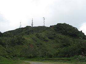 Cerro Punta, the highest peak of the Cordillera Central