- West Florida
-
This article is about the history of the region in colonial times. For the school, see University of West Florida.For information about the region as part of the U.S. territory and state of Florida from 1821 to the present, see Florida Panhandle.
West Florida Territory of Great Britain (1763–83), Spain (1783–1821). Areas disputed between Spain and the United States from 1783–1821. ← 
←
1763–1810  →
→
→
 →British West Florida in 1767.
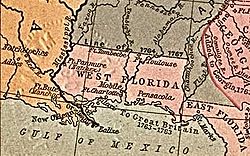
Capital Pensacola (1763) Governor - 1763 George Johnstone History - Treaty of Paris February 10 1763 - Transferred to Spain 1783 - Treaty of San Lorenzo 1795 - Treaty of San Ildefonso 1800 - Republic of West Florida 1810 - Annexation by U.S. October 27 1810 West Florida was a region on the north shore of the Gulf of Mexico, which underwent several boundary and sovereignty changes during its history. West Florida was first established in 1763 by the British government; as its name suggests it largely consisted of the western portion of the region called Florida by Spain, with East Florida comprising the eastern part. It included most of what is now the Florida Panhandle, plus parts of the modern U.S. states of Louisiana, Mississippi, and Alabama.
Britain formed West and East Florida out of land taken from France and Spain after the French and Indian War. As the newly acquired territory was too large to govern from one administrative center, the British divided it into two new colonies separated by the Apalachicola River. West Florida's government was based in Pensacola, and the colony included the part of formerly Spanish Florida west of the Apalachicola, plus the parts of French Louisiana taken by the British. It thus comprised all territory between the Mississippi and Apalachicola Rivers, with a northern boundary that shifted several times over the subsequent years.
Both West and East Florida remained loyal to the British crown during the American Revolution, and served as havens for Tories fleeing from the Thirteen Colonies. Spain invaded West Florida and captured Pensacola in 1781, and after the war Britain ceded both Floridas to Spain. However, the lack of defined boundaries led to a series of border disputes between Spain and the fledgling United States known as the West Florida Controversy. Disagreements with the Spanish government led American and English settlers between the Mississippi and Perdido Rivers to declare that area the independent Republic of West Florida in 1810. This was soon annexed by the United States, which claimed the region as part of the Louisiana Purchase of 1803. In 1819 the United States negotiated the purchase of the remainder of West Florida and all of East Florida in the Adams–Onís Treaty, and both were merged into the Florida Territory.
Contents
Background
The area known as West Florida was originally claimed by Spain as part of La Florida, which included most of what is now the southeastern United States. Spain made several attempts to conquer and colonize the area, notably including Tristán de Luna's short-lived settlement in 1559, but permanent settlement did not occur until the 17th century, with the establishments of missions to the Apalachee. In 1698 the settlement of Pensacola was established in order to check French expansion into the area.
Beginning in the late 17th century the French established settlements in the region as part of Louisiana, notably including Mobile (1702) and Fort Toulouse (1717) in present-day Alabama.[1] After years of contention the Perdido River (the modern border between Florida and Alabama) was agreed upon as the boundary between French Louisiana and Spanish Florida.[2]
In the treaty negotiations concluding the French and Indian War (Seven Years' War), France ceded to Britain the part of Louisiana east of the Mississippi River, notably excluding the Île d'Orléans, which includes New Orleans, to Britain. A separate treaty transferred the rest of Louisiana to Spain. Spain ceded Florida to Britain in exchange for Cuba, which the British had captured during the war. As a result of these exchanges the British controlled nearly all of the coast of the Gulf of Mexico east of the Mississippi.[1] Most of the Spanish population left Florida, and its colonial government records were relocated to Havana, Cuba.
History
British era
Finding this new territory too large to govern as one unit, the British divided it into two new colonies, West Florida and East Florida, separated by the Apalachicola River. East Florida consisted of most of the formerly Spanish Florida, and retained the old Spanish capital of St. Augustine. West Florida comprised the land between the Mississippi and Apalachicola Rivers, with Pensacola designated as its capital. The northern boundary was arbitrarily set at the 31st parallel north.[1]
Many English Americans and Scotch-Irish Americans moved to the territory at this time. The Governor of West Florida in November 1763 was George Johnstone; his lieutenant governor, Montfort Browne, was a major landowner in the province who heavily promoted its development. The British established an assembly, introducing democracy to the territory.
In 1764, the British moved the northern boundary to the 32° 22′ north latitude, extending from the Yazoo to the Chattahoochee River, which included the Natchez District and the Tombigbee District.[3] The appended area included approximately the lower half of the present states of Mississippi and Alabama. Many new settlers arrived in the wake of the British garrison, swelling the population. In 1774 the First Continental Congress sent letters inviting West Florida to send delegates, but this proposal was declined as the inhabitants were overwhelmingly Loyalist. During the American War of Independence the Governor of West Florida was Peter Chester. The commander of British forces during the war was John Campbell. The colony was attacked in 1778 by the Willing Expedition and then overrun in 1779-81 by Spanish forces under Bernardo de Gálvez, culminating in the Siege of Pensacola.
Spanish era
In the 1783 Treaty of Paris, which ended the war, the British agreed to a boundary between the United States and West Florida at 31° north latitude between the Mississippi and Apalachicola Rivers. Britain also ceded both Florida provinces back to Spain, which continued to maintain them as separate colonies. However, the treaty did not specify the boundaries, sparking the West Florida Controversy. Spain claimed the expanded 1764 boundary, while the United States claimed that the boundary was at the 31st parallel. Negotiations in 1785-1786 between John Jay and Don Diego de Gardoqui failed to reach a satisfactory conclusion. The border was finally resolved in 1795 by the Treaty of San Lorenzo, in which Spain recognized the 31st parallel as the boundary.
In the secret Treaty of San Ildefonso of 1800, Spain returned Louisiana to France; however, the boundaries were not specified. After France sold the Louisiana Purchase to the United States in 1803, another boundary dispute erupted. The United States laid claim to the territory from the Perdido River to the Mississippi River, which the Americans believed had been a part of the old province of Louisiana when the French had ceded it in 1763. The Spanish insisted that they had administered that portion as the province of West Florida and that it was not part of the territory returned to France in 1800.[4]
Republic of West Florida
 The Bonnie Blue Flag of the Republic of West Florida.
The United States and Spain held long, inconclusive negotiations on the status of West Florida. In the meantime, American settlers established a foothold in the area and resisted Spanish control. British settlers, who had remained, also resented Spanish rule, leading to a rebellion in 1810 and the establishment for exactly 90 days of the Republic of West Florida.
On September 23, 1810, after meetings beginning in June, rebels overcame the Spanish garrison at Baton Rouge and unfurled the flag of the new republic: a single white star on a blue field. This flag was made by Melissa Johnson, wife of Major Isaac Johnson, the commander of the West Florida Dragoons. It would later become known as the "Bonnie Blue Flag".[5]
The boundaries of the Republic of West Florida included all territory south of the 31st parallel, west of the Perdido River, and east of the Mississippi River, but north of Lake Pontchartrain. The southern boundary was the Gulf of Mexico. It included Baldwin and Mobile counties in what is now Alabama; the Mississippi counties of Hancock, Pearl River, Harrison, Stone, Jackson, and George, as well as the southernmost portions of Lamar, Forrest, Perry, and Wayne counties; and the Louisiana parishes of East Baton Rouge, East and West Feliciana, Livingston, St. Helena, Tangipahoa, St. Tammany and Washington. Despite its name, none of present-day Florida lay within its borders. The capital of the Republic of West Florida was St. Francisville in present-day Louisiana, on a bluff along the Mississippi River.
The Constitution of West Florida was based largely on the United States Constitution, and divided the government into three branches: executive, judicial, and legislative. The legislature consisted of a Senate and House of Representatives. The Governor was chosen by the legislature. According to the constitution, the official name of the nation was the "State of Florida". The first and only governor was Fulwar Skipwith, a former American diplomat who had helped negotiate the Louisiana Purchase. In his inaugural address, Skipwith mentioned the possibility of annexation to the United States:
“ ...wherever the voice of justice and humanity can be heard, our declaration, and our just rights will be respected. But the blood which flows in our veins, like the tributary streams which form and sustain the father of rivers, encircling our delightful country, will return if not impeded, to the heart of our parent country. The genius of Washington, the immortal founder of the liberties of America, stimulates that return, and would frown upon our cause, should we attempt to change its course. ” Reuben Kemper led a small force in an attempt to capture Mobile from the Spanish, but the expedition ended in failure. The marching song of the West Floridian army included the lyrics:
- West Floriday, that lovely nation,
- Free from king and tyranny,
- Thru’ the world shall be respected,
- For her true love of Liberty.
American annexation of the Republic
 The Republic of West Florida, today divided among three states.
On October 27, 1810, the ostensible Republic of West Florida was annexed by proclamation of U.S. President James Madison, who claimed the region as part of the Louisiana Purchase. At first, Skipwith and the West Florida government were opposed to the proclamation, preferring to negotiate terms to join the Union. However, William C. C. Claiborne, who was sent to take possession of the territory, refused to recognize the legitimacy of the West Florida government. Skipwith proclaimed that he was ready to "die in defense of the Lone Star flag."[6] However, Skipwith and the legislature eventually backed down and agreed to accept Madison's proclamation.
The United States took possession of St. Francisville on December 6, 1810, and of Baton Rouge on December 10, 1810. These portions were incorporated into the newly formed Territory of Orleans. The U.S. annexed the Mobile District of West Florida to the Mississippi Territory in 1812.
Later history
The Spanish continued to dispute the annexation of the western parts of its West Florida colony, but their power in the region was too weak to do anything about it. They continued administering the remainder of the colony (between the Perdido and Apalachicola Rivers) from the capital at Pensacola.
In 1819 Spain and the United States agreed to the Adams-Onís Treaty. In this treaty Spain ceded both West and East Florida to the United States in exchange for compensation and the renunciation of American claims to Texas.[7] The treaty took effect in 1821 and the U.S. military took over governance of both Floridas, establishing the current boundaries. The United States organized the Florida Territory on March 30, 1822; it was admitted to the Union as a state in 1845.
West Florida had an effect on chosing the location of Florida's current capital. At first, the Florida territorial Legislative Council determined to rotate between the historical capitals of Pensacola and St. Augustine. The first legislative session was held at Pensacola on July 22, 1822; this required delegates from St. Augustine to travel 59 days by sea to attend. To get to the second session in St. Augustine, Pensacola members traveled 28 days over land. During this session, the council decided future meetings should be held at a half-way point to reduce the distance; eventually Tallahassee, site of an Apalachee settlement in the early 18th century, was selected as a half-way point between the former capitals of East and West Florida.[8]
The portions of West Florida now located in Louisiana are known as the Florida Parishes. The Republic of West Florida Historical Museum is located in Jackson. In 1993, the Louisiana State Legislature renamed Interstate 12, the full length of which is contained in the Florida Parishes, as the "Republic of West Florida Parkway." In 2002, Leila Lee Roberts, a great-granddaughter of Fulwar Skipwith, donated the original copy of the constitution of the West Florida Republic and supporting papers to the Louisiana State Archives.
Governors
See also: Royal Governor of La FloridaGovernors under British rule:
- George Johnstone (1763–66)
- Montfort Browne (acting, 1766–1769)
- John Eliot (appointed 1767, arrived April 1769, committed suicide shortly afterward)
- Montfort Browne (acting, 1769)
- Elias Durnford (acting, 1769–1770)
- Peter Chester (1770–1781)
Governors under Spanish rule:
- Arturo O'Neill de Tyrone: (May 9, 1781–1794)
- Enrique White: (1794–1796)
- Francisco de Paula Gelabert: (1796)
- Vicente Folch y Juan: (June 1796 – March 1811)
- Francisco San Maxent: (March 1811 – 1812)
- Mauricio de Zúñiga: (1812–1813)
- Mateo González Manrique: (1813–1815)
- José de Soto: (1815–1816)
- Mauricio de Zúñiga: (1816)
- Francisco San Maxent: (1816)
- José Masot: (1816 - May 26, 1818)
- William King: (United States military governor, May 26, 1818 – February 4, 1819)
- José María Callava: (February 4, 1819 – July 17, 1821)
See also
- West Florida Controversy
- Adams-Onis Treaty
- French colonization of the Americas
- British colonization of the Americas
- Spanish colonization of the Americas
Notes
- ^ a b c Gannon, p. 134.
- ^ Gannon, p. 122.
- ^ The National Archives (British), Discussion of the Privy Council. PC 1/59/5/1
- ^ Text of the Adams-Onis Treaty, 1819], at The Avalon Project. Accessed 27 October 2011. See footnote 1.
- ^ Confederate National and Bonnie Blue Flags.
- ^ See inserted "Bonnie Blue Flag" image. The Republic of West Florida was also known as the Lone Star Republic.[citation needed]
- ^ Britannica Online entry "Transcontinental Treaty
- ^ Florida: A Short History, Michael V. Gannon, ISBN 0-8130-1167-1, Copyright @ 1993 by the Board of Regents of the State of Florida
References
- Arthur, Stanley Clisby. The Story of the West Florida Rebellion, St. Francisville Democrat, 1935, paperback, 164 pages (Several copies are available on ABE); Pioneer Publishing, paperback reprint, . ISBN 1-885480-47-4. OCLC 1354769.
- Bice, David A. The Original Lone Star Republic: Scoundrels, Statesmen and Schemers of the 1810 West Florida Rebellion, Heritage Publishing Consultants, 2004 . ISBN 1891647814. OCLC 56994640.
- Cox, Isaac Joslin. The West Florida Controversy (1918, reprinted 1967). OCLC 479174.
- Gannon, Michael (1996). The New History of Florida. University Press of Florida. ISBN 0813014158.
- McMichael, Francis Andrew (2000). Reluctant Revolutionaries: The West Florida Borderlands, 1785-1810. Vanderbilt University (Ph.D. Thesis) (Order Number: 9996212). OCLC 53820609.
- McMichael, Andrew "The Kemper 'Rebellion': Filibustering and Resident Anglo American Loyalty in Spanish West Florida," Louisiana History, vol. 43, no. 2 (Spring 2002), p. 140. . OCLC 1782994
- McMichael, Francis Andrew. Atlantic Loyalties: Americans in Spanish West Florida, 1785-1810, University of Georgia Press, 2008. . ISBN 9780820330044. OCLC 136777311.
- West Florida Collection, Center for Southeast Louisiana Studies, Linus A. Sims Memorial Library, Southeastern Louisiana University, Hammond. For a summary of the holdings see http://www.selu.edu/acad_research/programs/csls/historical_collections/archival_collections/t_z/wfla_coll.html.
External links
Categories:- States and territories established in 1763
- States and territories disestablished in 1810
- West Florida
- Former regions and territories of the United States
- Colonial United States (British)
- Pre-state history of Alabama
- Pre-state history of Florida
- Pre-state history of Louisiana
- Pre-state history of Mississippi
- Former colonies in North America
- International territorial disputes of the United States
- Former countries in North America
- Former unrecognized countries
- Former republics


Wikimedia Foundation. 2010.