- East Hartford, Connecticut
-
East Hartford, Connecticut — Town — Main Street at the intersection with Burnside Avenue

Flag
SealLocation in Hartford County, Connecticut
Coordinates: 41°45′41″N 72°36′55″W / 41.76139°N 72.61528°WCoordinates: 41°45′41″N 72°36′55″W / 41.76139°N 72.61528°W Country United States State Connecticut NECTA Hartford Region Capitol Region Incorporated 1783 Government – Type Mayor-council – Mayor Marcia Leclerc (D) Area – Total 18.8 sq mi (48.7 km2) – Land 18.0 sq mi (46.7 km2) – Water 0.8 sq mi (2.0 km2) Elevation 39 ft (12 m) Population (2010)[1] – Total 51,252 – Density 2,847/sq mi (1,097/km2) Time zone Eastern (UTC-5) – Summer (DST) Eastern (UTC-4) ZIP code 06108, 06118 Area code(s) 860 FIPS code 09-22630 GNIS feature ID 0213424 Website http://easthartfordct.gov/ East Hartford (41n47, 72w37 EST) is a town in Hartford County, Connecticut, United States. The population was 51,252 at the 2010 census.
Contents
Geography
According to the United States Census Bureau, the town has a total area of 18.8 square miles (48.6 km²), of which, 18.0 square miles (46.7 km²) of it is land and 0.8 square miles (2.0 km²) of it (4.05%) is water.
History
When the Connecticut Valley became known to Europeans around 1631, it was inhabited by what were known as the River Tribes — a number of small clans of Native Americans living along the Great River and its tributaries. Of these tribes the Podunks occupied territory now lying in the towns of East Hartford and South Windsor, and numbered, by differing estimates, from sixty to two hundred bowmen. They were governed by two sachems, Waginacut and Arramamet, and were connected in some way with the Native Americans who lived across the Great River, in Windsor. The region north of the Hockanum river was generally called Podunk; that south of the river, Hockanum; but these were no certain designations, and by some all the meadow along the Great River was called Hockanum.[2]
In 1659, Thomas Burnham (1617–1688) purchased the tract of land now covered by the towns of South Windsor and East Hartford from Tantinomo, Chief sachem of the Podunk Indians.[2] Burnham lived on the land and later willed it to his nine children.[3] The town of Hartford once included the land now occupied by the towns of East Hartford, Manchester, and West Hartford. In 1783, East Hartford became a separate town, which included Manchester in its city limits until 1823.[2]
Demographics
As of the census[4] of 2000, there were 49,575 people, 20,206 households, and 12,830 families residing in the town. The population density was 2,750.5 people per square mile (1,062.2/km²). There were 21,273 housing units at an average density of 1,180.2 per square mile (455.8/km²). The racial makeup of the town was 64.69% White, 18.83% Black or African American, 0.34% Native American, 4.01% Asian, 0.04% Pacific Islander, 8.74% from other races, and 3.35% from two or more races. Hispanic or Latino of any race were 15.23% of the population.
There were 20,206 households out of which 29.2% had children under the age of 18 living with them, 41.5% were married couples living together, 17.4% had a female householder with no husband present, and 36.5% were non-families. 30.2% of all households were made up of individuals and 11.3% had someone living alone who was 65 years of age or older. The average household size was 2.42 and the average family size was 3.01.
In the town the population was spread out with 24.1% under the age of 18, 7.8% from 18 to 24, 30.2% from 25 to 44, 22.3% from 45 to 64, and 15.6% who were 65 years of age or older. The median age was 37 years. For every 100 females there were 91.4 males. For every 100 females age 18 and over, there were 87.8 males.
The median income for a household in the town was $41,424, and the median income for a family was $50,540. Males had a median income of $36,823 versus $29,860 for females. The per capita income for the town was $21,763. About 8.1% of families and 10.3% of the population were below the poverty line, including 15.5% of those under age 18 and 7.3% of those age 65 or over.
Voter Registration and Party Enrollment as of October 30, 2007[5] Party Active Voters Inactive Voters Total Voters Percentage Democratic 11,321 1,088 12,409 45.82% Republican 2,820 305 3,125 11.54% Unaffiliated 10,087 1,420 11,507 42.48% Minor Parties 38 6 44 0.16% Total 24,266 2,819 27,085 100% Historical populations Census Pop. %± 1900 6,406 — 1910 8,138 27.0% 1920 11,648 43.1% 1930 17,125 47.0% 1940 18,615 8.7% 1950 29,933 60.8% 1960 43,977 46.9% 1970 57,583 30.9% 1980 52,563 −8.7% 1990 50,452 −4.0% 2000 49,575 −1.7% Est. 2007 50,633 2.1% Economy
East Hartford is home to the headquarters of Pratt & Whitney,[6] part of the United Technologies conglomerate. The manufacturing plant takes up a significant amount of East Hartford's area, and at its peak, it employed tens of thousands of people; however, currently, it only employs about 5,000. East Hartford also contains a Coca-Cola bottling plant, located on Main Street. The city is dotted with various industrial and suburban office parks.[citation needed]
Attractions
The East River Drive and Connecticut Boulevard areas, just east of the Connecticut River, contain extensive development, including car dealerships, medical offices, and light retail development. Notably, Goodwin College has begun to build a large campus on Riverside Drive. It will also develop blighted housing projects into student housing.
Wickham Park, located in both East Hartford and Manchester, features Oriental gardens, fountains, open fields, woodlands, ponds, picnic areas, softball fields, and an aviary. The west side of the park offers a scenic view of East Hartford and the skyline of Hartford across the Connecticut River.
Nearby, on the former Pratt & Whitney company airfield Rentschler Field, lies the recently-erected stadium of the same name (construction completed September 2003), home of the UConn Huskies football team and the Hartford Colonials of the United Football League. The stadium has also been used for concerts by artists including The Rolling Stones. The remainder of the former airfield is currently being redeveloped, with a $1 billion dollar technology, entertainment, lodging, and retail development planned. Hotels, technology companies, and various retail outlets are expected to begin construction in the near future as well.
Neighborhoods
 Hanmer St near Goodwin College
East Hartford is home to a diverse mix of neighborhoods. The northeast and southeast sections of the town are suburban and resemble neighboring towns like South Windsor, Connecticut and Glastonbury, Connecticut. People here tend to be middle class. In contrast, the older, more urban sections of the town are moderate and low income. Some of these neighborhoods include Hockanum in the southwest of the city, Burnside Avenue in the center of the city, and Mayberry Village.
Notable residents
- Lawrence Brainerd - Businessman, abolitionist and United States Senator from Vermont.
- Mary Cadorette - Actress
- Francis Patrick Garvan - Lawyer and long time president of the Chemical Foundation.
- John A. Gurley - U.S. Congressman from Ohio during the early part of the American Civil War.
- Hiram N. Moulton - Mayor of Madison, Wisconsin.
- Aaron Olmstead - Sea Captain, namesake of several cities in Ohio.
- Denison Olmsted - Physicist and astronomer.
- Gérard Ouellet - Member of the Canadian House of Commons.
- Diane Venora - Actress
References
- ^ U.S. Census Bureau Population Estimates
- ^ a b c Goodwin, Joseph Olcott (1879). East Hartford: Its History and Traditions. Hartford, Connecticut: Case, Lockwood, and Brainard Co..
- ^ Burnham, Roderick Henry (1869). The Burnham Family; Or Genealogical Records of the Descendants of the Four. Hartford, Connecticut: Case, Lockwood, and Brainard Co..
- ^ "American FactFinder". United States Census Bureau. http://factfinder.census.gov. Retrieved 2008-01-31.
- ^ "Registration and Party Enrollment Statistics as of October 30, 2007" (PDF). Connecticut Secretary of State. http://www.sots.ct.gov/sots/lib/sots/2007_Registration_and_Enrollment_Statistics.pdf. Retrieved 2008-09-18.
- ^ "Contact Us." Pratt & Whitney. Retrieved on January 7, 2011. "Corporate Headquarters Pratt & Whitney 400 Main Street East Hartford, CT 06108."
External links
- Town of East Hartford
- Historical Society of East Hartford - Related historical links.
- Central Regional Tourism District
 State of Connecticut
Topics - Index
- Culture
- Constitution
- Delegations
- Elections
- Geography
- Government
- History
- Images
- People
- Visitor Attractions
Regions Counties Cities Places Municipalities and communities of Hartford County, Connecticut Cities 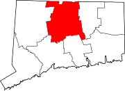
Towns Avon | Berlin | Bloomfield | Burlington | Canton | East Granby | East Hartford | East Windsor | Enfield | Farmington | Glastonbury | Granby | Hartland | Manchester | Marlborough | Newington | Plainville | Rocky Hill | Simsbury | South Windsor | Southington | Suffield | West Hartford | Wethersfield | Windsor Locks | Windsor
Unincorporated
communitiesBlue Hills | Broad Brook | Burnside | Collinsville | Hazardville | Hockanum | Kensington | Marion | Milldale | Newington Junction | North Granby | Plantsville | Sherwood Manor | Simsbury Center | Southwood Acres | Tariffville | Terramuggus | Thompsonville | Weatogue | West Simsbury
Categories:- East Hartford, Connecticut
- Towns in Hartford County, Connecticut
- Populated places on the Connecticut River


Wikimedia Foundation. 2010.