- Duxbury, Massachusetts
-
"Duxbury" redirects here. For other uses, see Duxbury (disambiguation).
Duxbury, Massachusetts — Town — Duxbury Town Offices

SealLocation in Plymouth County in Massachusetts
Coordinates: 42°02′30″N 70°40′22″W / 42.04167°N 70.67278°WCoordinates: 42°02′30″N 70°40′22″W / 42.04167°N 70.67278°W Country United States State Massachusetts County Plymouth Settled 1624 Incorporated 1637 Government - Type Open town meeting Area - Total 37.6 sq mi (97.4 km2) - Land 23.8 sq mi (61.5 km2) - Water 13.9 sq mi (35.9 km2) Elevation 36 ft (11 m) Population (2010) - Total 15,059 - Density 632.7/sq mi (244.9/km2) Time zone Eastern (UTC-5) - Summer (DST) Eastern (UTC-4) ZIP code 02332 Area code(s) 339 / 781 FIPS code 25-17895 GNIS feature ID 0618338 Website www.town.duxbury.ma.us Duxbury is a coastal town in Plymouth County, Massachusetts, United States. Duxbury is a suburb of Boston, located approximately 35 miles (56 km) to the south of the city on the South Shore. The population was 15,059 at the 2010 census.
Geographic and demographic information on the specific parts of the town of Duxbury is available in articles Cedar Crest, Duxbury (CDP), Duxbury Beach, and South Duxbury, respectively.
Contents
History
The area now known as Duxbury was inhabited by people as early as 12,000 to 9,000 B.C. By the time European settlers arrived here, the region was inhabited by the Wampanoags, who called this place Mattakeesett, meaning “place of many fish.”[1]
In 1620, the English settlers known as the Pilgrims established their colony in Plymouth. Per the terms of their contract with financial backers in London, they were required to live together in a tight community for seven years. At the end of that term in 1627, land along the coast was allotted to settlers for farming. Thus, the coastline from Plymouth to Marshfield was parceled out, and many settlers began moving away from Plymouth.[1]
At first, those who settled in Duxbury came to work their new farms just in the warmer months and returned to Plymouth during the winter. It was not long, however, before they began to build homes on their land, and soon requested permission from the colony to be set off as a separate community with their own church. Duxbury, which originally included land that is now Pembroke, was incorporated in 1637.[1]
Some of the most influential men in the colony received grants in Duxbury and became its first leaders. Captain Myles Standish, the military leader of the colony, lived in “the Nook,” an area now known as Standish Shore. Elder William Brewster was, for many years, the religious leader of the colony. He probably named Duxbury after his possible home of Duxbury Hall, in Chorley, England, in which he led services to the colony until it received its own minister in 1637. John Alden was another important settler. His house, now a museum on Alden Street, was the site of many important meetings of the colony’s leaders. The graves of some of Duxbury’s first settlers can be found in the Old Burying Ground on Chestnut Street, next to the site of original meetinghouse.[1] Theory has it that the town was named by Myles Standish after the family estate of his childhood in Lancashire. The ancient Standish family in northern England owned much land and large estates, including the two main family headquarters of Standish Hall and Duxbury Manor, in Lancashire, since the before the Middle Ages. Myles Standish's will delineates his inheritance rights to very particular lands near and around Standish and mostly Duxbury Manor, stating his descent from both lines of the Standish family; and so it has been suggested that he named the new town in Massachusetts after the estate where he grew up.
Duxbury was primarily a farming community throughout the 17th and 18th centuries. Its quiet history in the 18th century was interrupted only by the Revolutionary War.[1]
The most remarkable period in Duxbury’s history, the shipbuilding era, began immediately after the Revolution. Following the Treaty of Paris, the newborn nation was granted fishing rights on the Grand Banks. Several families took advantage of the new opportunity and began to build large fishing schooners. Soon, the schooners built in the 1790s gave way to larger brigs and eventually three-masted ships. As several merchant families began to amass large fleets, shipyards and other ancillary industries flourished and Duxbury prospered. By the 1840s, Duxbury boasted about 20 shipyards and produced an average of ten large sailing vessels per year.[1]
 John Alden House, built 1653
 Beach and residences c. 1910
Early Industry
The largest industry in Duxbury was owned by Ezra Weston, who came to be known as "King Caesar" due to his success and influence. Weston began building small vessels in 1764 and soon became famous for his successful merchant fleet. His son, Ezra II, who inherited his father’s kingly sobriquet, would bring the industry to its height. By 1841, the younger King Caesar had constructed the largest vessel built in New England up to that time. The ship Hope was an astounding 880 tons. Lloyd's of London recognized Weston as the owner of the largest fleet in America, and this judgment was confirmed by Daniel Webster in a speech in 1841. His empire, a fore-runner of vertical integration, dominated the town.[1] The King Caesar House is now a museum owned by the Duxbury Rural and Historical Society.
The shipbuilding era in Duxbury ended as quickly as it began. By the 1850s, sailing vessels were made obsolete by other modes of transportation such as steamships and railroads. While other Massachusetts towns grew, Duxbury went into a long economic decline.[1]
There was, however, a silver lining. By the 1870s, Duxbury’s rural character and unspoiled bay began to attract summer visitors. Duxbury soon gained a reputation as an idyllic summer resort. With the 1871 completion of the Duxbury & Cohasset Railroad,[2] large numbers of city-folk from Boston could pay $1.50 for a round-trip ticket and enjoy Duxbury’s refreshing environment. Boarding houses sprang up everywhere. The Miles Standish Hotel on the Nook soon became enormously popular. The Myles Standish monument, completed in 1898, was a result of this tourist influx.[1]
This pattern continued in Duxbury well into the 20th-century. It was not until the construction of Route 3 that transportation to Boston became expedient and the town’s population exploded with the arrival of thousands of year-round residents.[1]
Geography
 View of Bluefish River inlet with King Caesar House in background (left)
According to the United States Census Bureau, the town has a total area of 37.6 square miles (97.4 km²), of which, 23.8 square miles (61.5 km²) of it is land and 13.9 square miles (35.9 km²) of it (36.87%) is water. Duxbury is bordered by Cape Cod Bay to the east, Duxbury Bay, Kingston Bay and Plymouth to the southeast, Kingston to the southwest, Pembroke to the west and northwest, and Marshfield to the north. The town's border with Plymouth is due to the town having the only land access to Saquish Neck, a thin, hook-shaped strip of land along Duxbury Bay whose tip is in Plymouth.
Duxbury is the sixth largest cranberry producer in Massachusetts. It also has come in recent years to be known for its oyster beds, as well as other shellfish. The town has many ponds and bogs throughout. The Back River lies along the western edge of Saquish Neck, and has many tributaries from the local rivers, brooks and marshes. There are several sanctuaries, a conservation area and other forests within the town, especially in the western half of town.
Demographics
Historical populations Year Pop. ±% 1850 2,679 — 1860 2,597 −3.1% 1870 2,341 −9.9% 1880 2,196 −6.2% 1890 1,908 −13.1% 1900 2,075 +8.8% 1910 1,688 −18.7% 1920 1,553 −8.0% 1930 1,696 +9.2% 1940 2,359 +39.1% 1950 3,167 +34.3% 1960 4,727 +49.3% 1970 7,636 +61.5% 1980 11,807 +54.6% 1990 13,895 +17.7% 2000 14,248 +2.5% 2001* 14,281 +0.2% 2002* 14,395 +0.8% 2003* 14,392 −0.0% 2004* 14,310 −0.6% 2005* 14,204 −0.7% 2006* 14,130 −0.5% 2007* 14,165 +0.2% 2008* 14,239 +0.5% 2009* 14,363 +0.9% 2010 15,059 +4.8% * = population estimate.
Source: United States Census records and Population Estimates Program data.[3][4][5][6][7][8][9][10][11][12]As of the census[13] of 2000, there were 14,248 people, 4,946 households, and 3,941 families residing in the town. The population density was 599.8 people per square mile (231.6/km²). There were 5,345 housing units at an average density of 225.0 per square mile (86.9/km²). The racial makeup of the town was 97.80% White, 0.64% Black or African American, 0.10% Native American, 0.65% Asian, 0.01% Pacific Islander, 0.26% from other races, and 0.55% from two or more races. Hispanic or Latino of any race were 0.72% of the population.
There were 4,946 households out of which 41.6% had children under the age of 18 living with them, 70.8% were married couples living together, 6.7% had a female householder with no husband present, and 20.3% were non-families. 17.7% of all households were made up of individuals and 10.1% had someone living alone who was 65 years of age or older. The average household size was 2.85 and the average family size was 3.26.
In the town the population was spread out with 29.6% under the age of 18, 4.6% from 18 to 24, 24.1% from 25 to 44, 29.8% from 45 to 64, and 12.0% who were 65 years of age or older. The median age was 40 years. For every 100 females there were 92.3 males. For every 100 females age 18 and over, there were 87.1 males.
The median income for a household in the town was $97,124, and the median income for a family was $106,245. Males had a median income of $77,228 versus $41,730 for females. The per capita income for the town was $40,242. About 1.2% of families and 2.3% of the population were below the poverty line, including 3.1% of those under age 18 and 3.1% of those age 65 or over.
Government
On the national level, Duxbury is a part of Massachusetts's 10th congressional district, and is currently represented by Bill Keating. The state's senior (Class II) member of the United States Senate, re-elected in 2008, is John Kerry. The junior (Class I) senator, elected in 2010, is Scott Brown.
On the state level, Duxbury is represented in the Massachusetts House of Representatives as a part of the Sixth and the Twelfth Plymouth districts; the Sixth includes the towns of Hanson, Pembroke and portions of Halifax, and the Twelfth includes all or parts of the towns of Halifax, Kingston, Middleborough, Plymouth and Plympton. The town is represented in the Massachusetts Senate as a part of the Plymouth and Norfolk district, which includes the towns of Cohasset, Hingham, Hull, Marshfield, Norwell, Scituate and Weymouth.[14] The town is patrolled by the First (Norwell) Barracks of Troop D of the Massachusetts State Police.[15]
Duxbury is governed by the open town meeting form of government, and is led by a town manager and a board of selectmen. The town operates its own police and fire departments, with the police station located near the junction of Routes 14 and 139, and fire stations located in the northwest and southeast parts of town. There are two post offices in town; one is at Hall's Corner (near Goose Point) and the other is at Snug Harbor, along Duxbury Bay just south of Powder Point. The Duxbury Free Library is located in the heart of town, next to the John Alden House, and is a member of the Old Colony Library Network. The town also has a highway department, located behind the Town Hall, and a harbormaster, whose office is located next to the Duxbury Yacht Club near Snug Harbor. Duxbury is located within ten miles (16 km) of the Pilgrim Nuclear Power Station, and as such has a well-organized emergency management agency. The nearest hospitals are Jordan Hospital in Plymouth, South Shore Hospital in Weymouth, and Brockton Hospital.
Voter Registration and Party Enrollment as of October 15, 2008[16] Party Number of Voters Percentage Democratic 2,236 20.13% Republican 2,545 22.91% Unaffiliated 6,277 56.51% Minor Parties 50 0.45% Total 11,108 100% Education
Public schools
Over $26 million of Duxbury's annual budget is devoted to the town's nationally recognized public school system. According to Newsweek Magazine's 2005, 2006 and 2007 rankings of the Nation's Top 1200 Public High Schools (the top 5% of public school systems), Duxbury was ranked at 246, 185 and 142 respectively.
Duxbury operates its own school system for the town's approximately 3,400 students, serving preschool through 12th grade. Chandler School is located near Tree of Knowledge Corner in the west of town and serves students from pre-kindergarten through second grade. The Alden Elementary School, located near the John Alden House, serves grades 3-5. The Duxbury Middle School is located adjacent to the Alden School, and serves grades 6-8.
Duxbury High School is located across Saint George Street from the middle school, and serves grades 9-12. Duxbury High's athletic teams are known as the Dragons, and their colors are green and white. Their chief rival is Marshfield High School, team mascot the rams, and play against them in the Thanksgiving Day Tournament. It is an important local event whose rivalry goes back more than 80 years.
Private schools
There are two private schools located in Duxbury. The Bay Farm Montessori Academy is a private, independent school located in the southern corner of town and serves Toddlers through grade 8. Good Shepherd Christian Academy is a private, Christian school which serves students from kindergarten through eighth grade. The nearest private high school is Sacred Heart in Kingston. The town does not have any agreements with vocational schools.
Higher education
The nearest college is Bridgewater State University in Bridgewater, Massachusetts.
Transportation
Bus
For busses in Duxbury, the local GATRA (Greater Attleboro Taunton Regional transit Authority) buss passes through the town on the SAIL line (Seaside Area Inter-town Link) and it stops at Halls Corner shopping district (South Duxbury), Island Creek, Millbrook Motors (Cox Corner), and the Duxbury Free Library (Millbrook). Another Bus Line that goes through Duxbury is the P&B Line (Plymouth & Brockton) which stops at Millbrook Motors (Cox Corner). The last bus line that goes through Duxbury is the Greyhound Bus Line which runs national service and into Canada, which stops at Millbrook Motors (Cox Corner).
Road
Route 3, a two-lane freeway also known as the Pilgrims Highway, passes through the town, with one exit granting access to the town from it. Routes 3A, 14, 53 and 139 also pass through the town. Routes 14 and 139 both end in the town, and Route 53 ends less than 1/2 mile south of the town line, at Route 3A.
Other
There is no rail or air service in town. The Kingston-Plymouth Line of the MBTA's commuter rail passes through (and terminates in) neighboring Kingston and Plymouth, as the southern end of a route which starts at South Station in Boston. The nearest municipal airport is Marshfield Municipal Airport; the nearest national and international air service can be reached at Logan International Airport in Boston.
Notable residents
- Ichabod Alden, (1739–1778), officer in the American Revolution[17]
- John Alden, a Mayflower immigrant and one of the founders of Duxbury[17]
- Love Brewster, a founder of the town of Duxbury.
- Elder William Brewster (pilgrim), (c. 1567 - April 10, 1644), the Pilgrim leader and spiritual elder of the Plymouth Colony and a passenger on the Mayflower. He was also and one of the founders of Duxbury.
- Captain/Deputy Governor Myles Standish, (1584–1656) a Mayflower settler and founder of Duxbury.
- Bill Curley, former NBA center for San Antonio Spurs basketball team
- Captain Amasa Delano (b. 1763), became fictionalized as a character in Herman Melville's 1855 novella Benito Cereno
- Bobby Farrelly, screenwriter, director; with brother Peter wrote and directed popular films including Dumb and Dumber, There's Something About Mary, and Shallow Hal
- Juliana Hatfield (b. 1967), indie rock singer
- Pat Leahy, NHL hockey player for the Boston Bruins
- Philip Parlier, former shortstop for the Cincinnati Reds baseball team
- George Partridge, a representative to Continental Congress and the First United States Congress
- Joe Perry, guitarist for Aerosmith
- George Soule, a Mayflower Pilgrim, signer of the Mayflower Compact and one of the founders of Duxbury[18]
- Mike Sullivan, former coach of the Boston Bruins
- Ezra Weston, Jr., referred to colloquially as King Caesar. Weston's shipbuilding enterprise dominated Duxbury in the early 19th century with a large portion of the population employed in the Weston shipyards, farms, wharves, mill, ropewalk, or aboard Weston’s fishing schooners and merchant fleet. The King Caesar House is now a tourist attraction in town.
Points of interest
 The Myles Standish Monument, not far from the site of his home
 Powder Point Bridge
- Alexander Standish House, built in 1666.
- Art Complex Museum: The Carl A. Weyerhaeuser collection.[19]
- Captain Daniel Bradford House
- Capt. Gamaliel Bradford House
- Duxbury Free Library
- First Parish Church, Unitarian Universalist: Founded in 1632 by the Pilgrims, it was the second religious body of the Plymouth Colony.[20]
- Gershom Bradford House: This early 19th century house remains virtually untouched from when it was built and furnished by the seafaring captain. It remained in the family for four generations until donated to the Duxbury Rural and Historical Society.[21]
- Hall's Corner: Duxbury's main commercial and retail shopping area, centering around the flagpole.
- John Alden House, built in 1653, home to Pilgrim John Alden.
- King Caesar House[22]
- Myles Standish Burial Ground, cemetery and Pilgrim burial site.
- Myles Standish Monument State Reservation[23]
- Snug Harbor: A charming harborfront with small shops on Washington Street.
- North Hill Marsh: The Massachusetts Audubon Society's 129-acre (0.52 km2) sanctuary on Mayflower Street includes a forest, bike trails, and a 90-acre (360,000 m2) pond.[24]
- Old Shipbuilder's Historic District
- Pillsbury Summer House
- Powder Point Bridge
- Tinkertown: A quaint hamlet of Duxbury settled in the early 18th century. The illumination of luminaries on Christmas Eve is a Tinkertown tradition dating back generations.
- Mill Pond, Island Creek Pond, Island Creek Information
- Camp Wing: Located in Duxbury's northeast tip, it is a summer camp with many year round events.
- Wright Memorial Library, home of the Duxbury Student Union and the Drew Archival Library of the Duxbury Rural and Historical Society
- Nathaniel Winsor, Jr. House headquarters of the Duxbury Rural and Historical Society
- Far Far's Ice Cream amazing ice cream location
Newspapers
See also
- Duxbury High School
- Duxbury (CDP), Massachusetts
- Duxbury Beach
- South Duxbury, Massachusetts
- Duxbury Bay (Massachusetts)
- Duxbury Rural and Historical Society
- Round Pond (Duxbury, Massachusetts)
- Pine Lake (Duxbury, Massachusetts)
- Mill Pond (Duxbury, Massachusetts)
- First Parish Church (Duxbury, Massachusetts)
- South Shore Railroad
- Island Creek Pond
- Myles Standish Burial Ground
- Old Shipbuilder's Historic District
- North Hill Marsh Pond
- John and Priscilla Alden Family Sites
- Myles Standish Monument State Reservation
- Nathaniel Winsor, Jr. House
- TAB the Band
- Alexander Standish House
- Lower Chandler Pond
- Upper Chandler Pond
- Art Complex Museum
- Pine Street Pond
- Keene Pond
- Alden Island
- Bartlett Rock (Plymouth County, Massachusetts)
- Massachusetts Route 14
- King Caesar House
- Wright Memorial Library
- Massachusetts Route 3A
- Massachusetts Route 3
- Massachusetts Route 139
References
- ^ a b c d e f g h i j Duxbury in Brief: A Historical Sketch
- ^ Massachusetts Board of Railroad Commissioners, Annual report of the Board of Railroad Commissioners Boston, Massachusetts 1878 -- Duxbury & Cohasset Railroad
- ^ "TOTAL POPULATION (P1), 2010 Census Summary File 1, All County Subdivisions within Massachusetts". United States Census Bureau. http://factfinder2.census.gov/bkmk/table/1.0/en/DEC/10_SF1/P1/0400000US25.06000. Retrieved September 13, 2011.
- ^ "Massachusetts by Place and County Subdivision - GCT-T1. Population Estimates". United States Census Bureau. http://factfinder.census.gov/servlet/GCTTable?_bm=y&-geo_id=04000US25&-_box_head_nbr=GCT-T1&-ds_name=PEP_2009_EST&-_lang=en&-format=ST-9&-_sse=on. Retrieved July 12, 2011.
- ^ "1990 Census of Population, General Population Characteristics: Massachusetts". US Census Bureau. December 1990. Table 76: General Characteristics of Persons, Households, and Families: 1990. 1990 CP-1-23. http://www.census.gov/prod/cen1990/cp1/cp-1-23.pdf. Retrieved July 12, 2011.
- ^ "1980 Census of the Population, Number of Inhabitants: Massachusetts". US Census Bureau. December 1981. Table 4. Populations of County Subdivisions: 1960 to 1980. PC80-1-A23. http://www2.census.gov/prod2/decennial/documents/1980a_maABC-01.pdf. Retrieved July 12, 2011.
- ^ "1950 Census of Population". Bureau of the Census. 1952. Section 6, Pages 21-10 and 21-11, Massachusetts Table 6. Population of Counties by Minor Civil Divisions: 1930 to 1950. http://www2.census.gov/prod2/decennial/documents/23761117v1ch06.pdf. Retrieved July 12, 2011.
- ^ "1920 Census of Population". Bureau of the Census. Number of Inhabitants, by Counties and Minor Civil Divisions. Pages 21-5 through 21-7. Massachusetts Table 2. Population of Counties by Minor Civil Divisions: 1920, 1910, and 1920. http://www2.census.gov/prod2/decennial/documents/41084506no553ch2.pdf. Retrieved July 12, 2011.
- ^ "1890 Census of the Population". Department of the Interior, Census Office. Pages 179 through 182. Massachusetts Table 5. Population of States and Territories by Minor Civil Divisions: 1880 and 1890. http://www2.census.gov/prod2/decennial/documents/41084506no553ch2.pdf. Retrieved July 12, 2011.
- ^ "1870 Census of the Population". Department of the Interior, Census Office. 1872. Pages 217 through 220. Table IX. Population of Minor Civil Divisions, &c. Massachusetts. http://www2.census.gov/prod2/decennial/documents/1870e-05.pdf. Retrieved July 12, 2011.
- ^ "1860 Census". Department of the Interior, Census Office. 1864. Pages 220 through 226. State of Massachusetts Table No. 3. Populations of Cities, Towns, &c.. http://www2.census.gov/prod2/decennial/documents/1860a-08.pdf. Retrieved July 12, 2011.
- ^ "1850 Census". Department of the Interior, Census Office. 1854. Pages 338 through 393. Populations of Cities, Towns, &c.. http://www2.census.gov/prod2/decennial/documents/1850c-11.pdf. Retrieved July 12, 2011.
- ^ "American FactFinder". United States Census Bureau. http://factfinder.census.gov. Retrieved 2008-01-31.
- ^ Index of Legislative Representation by City and Town, from Mass.gov
- ^ Station D-1, SP Norwell
- ^ "Registration and Party Enrollment Statistics as of October 15, 2008" (PDF). Massachusetts Elections Division. http://www.sec.state.ma.us/ele/elepdf/st_county_town_enroll_breakdown_08.pdf. Retrieved 2010-05-08.
- ^ a b Who Was Who in America, Historical Volume, 1607-1896. Marquis Who's Who. 1967.
- ^ Title: Mayflower Families Through Five Generations- George Soule, Volume 3 Author: John E Soule, Col. and Milton E. Perry, Ph.D. Publication: General Society of Mayflower Descendants, 1980 Abbrev: Mayflower Families Through Five Generations- George Soule, Volume 3
- ^ The Art Complex Museum - Home Page
- ^ First Parish Duxbury UU Church Home Page
- ^ Gershom Bradford House at duxburyhistory.org
- ^ King Caesar House
- ^ Myles Standish Monument State Reservation
- ^ North Hill Marsh page at Mass Audubon
External links
- Town of Duxbury
- Duxbury Free Library
- Duxbury Rural & Historical Society
- Duxbury Business Association
- Duxbury Clipper
- Duxbury Public Schools
- Duxbury Times
- First Parish Church Unitarian Universalist, Duxbury
- Map of Duxbury (Yahoo)
- Map of Duxbury Cemeteries
- Myles Standish Monument State Reservation
- North Hill Marsh
- Wicked Local Duxbury
- Answer Book/Duxbury: Everything you need to know
Municipalities and communities of Plymouth County, Massachusetts County seats: Brockton and Plymouth Cities 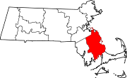
Towns Abington | Carver | Duxbury | East Bridgewater | Halifax | Hanover | Hanson | Hingham | Hull | Kingston | Lakeville | Marion | Marshfield | Mattapoisett | Middleborough | Norwell | Pembroke | Plymouth | Plympton | Rochester | Rockland | Scituate | Wareham | West Bridgewater | Whitman
CDPs Bridgewater | Duxbury | Green Harbor-Cedar Crest | Hanson | Hingham | Kingston | Marion Center | Marshfield | Marshfield Hills | Mattapoisett Center | Middleborough Center | North Lakeville | North Pembroke | North Plymouth | North Scituate | Ocean Bluff-Brant Rock | Onset | Plymouth Center | Scituate | South Duxbury | Wareham Center | West Wareham | Weweantic | White Island Shores
Other
villagesCategories:- Populated coastal places in Massachusetts
- Towns in Plymouth County, Massachusetts
- Duxbury, Massachusetts


Wikimedia Foundation. 2010.