- Meredith, New Hampshire
-
Meredith, New Hampshire — Town — Bird's-eye view of Meredith village

SealLocation in Belknap County, New Hampshire
Coordinates: 43°39′28″N 71°30′02″W / 43.65778°N 71.50056°WCoordinates: 43°39′28″N 71°30′02″W / 43.65778°N 71.50056°W Country United States State New Hampshire County Belknap Incorporated 1768 Government – Board of Selectmen Peter Brothers
Colette Worsman
Miller Lovett
Chuck Palm
Nate TorrArea – Total 54.2 sq mi (140.4 km2) – Land 39.9 sq mi (103.4 km2) – Water 14.3 sq mi (37.0 km2) 26.37% Elevation 508 ft (155 m) Population (2010) – Total 6,241 – Density 115.1/sq mi (44.5/km2) Time zone Eastern (UTC-5) – Summer (DST) Eastern (UTC-4) ZIP code 03253 Area code(s) 603 FIPS code 33-47140 GNIS feature ID 0873662 Website www.meredithnh.org Meredith is a town in Belknap County, New Hampshire, USA. The population was 6,241 at the 2010 census.[1] Meredith is situated beside Lake Winnipesaukee. It is home to Stonedam Island Natural Area and the Winnipesaukee Scenic Railroad. Meredith is the site of the annual Great Rotary Fishing Derby.
The primary village in town, where 1,718 people resided at the 2010 census,[2] is defined as the Meredith census-designated place (CDP), and is located at the junction of U.S. Route 3 and New Hampshire Route 25 at the head of Meredith Bay on Lake Winnipesaukee.
Contents
History
 Meredith village c. 1905
Meredith was first known as Palmer's Town in honor of Samuel Palmer, a teacher of surveying and navigation who laid out much of the land surrounding Lake Winnipesaukee. In 1748, it was one of the first towns to have a charter granted by the Masonian Proprietors. Many grantees were from Salem, Massachusetts, so Palmer's Town was renamed New Salem. It was settled in 1766 by Jacob Eaton and Colonel Ebenezer Smith, then regranted in 1768 by Governor John Wentworth and named after Sir William Meredith, 3rd Baronet, a member of Parliament who opposed taxation on the colonies.
Farmers grew corn, wheat, rye and potatoes, but the area became noted for apple orchards. The outlet of Lake Waukewan provided water power sites, and by 1859 Meredith village had a sawmill, gristmill, shingle mill, blacksmith shop, harness-maker's shop and tannery. Situated at the outlet of Wickwas Lake, Meredith Center had a sawmill, gristmill and blacksmith shop. Connected by the Boston, Concord & Montreal Railroad in March 1849, the town became a summer resort. Passengers also arrived from the Alton Bay depot aboard steamboats, the most famous of which was the original SS Mount Washington, launched in 1872. Meredith remains a popular tourist destination.
Geography
 Plymouth Street c. 1920
According to the United States Census Bureau, the town has a total area of 54.2 square miles (140 km2), of which 39.9 square miles (103 km2) is land and 14.3 square miles (37 km2) is water or 26.37%.[3] The highest point in Meredith is the summit of Leavitt Mountain, elevation 1,414 feet (431 m) above sea level, in the southwestern part of town.
Meredith village, or the Meredith census-designated place (CDP), has a total area of 1.9 sq mi (4.9 km2). 1.5 sq mi (3.9 km2) of it is land and 0.3 sq mi (0.78 km2) of it (18.38%) is water. Meredith is bounded to the northeast by Lake Winnipesaukee.
The town is crossed by U.S. Route 3, New Hampshire Route 25, New Hampshire Route 104, and New Hampshire Route 106. It is bordered by the towns of Sanbornton to the southwest, New Hampton to the west, Center Harbor to the north, Moultonborough to the northeast across Lake Winnipesaukee, Gilford to the southeast, and Laconia to the south.
Demographics
As of the census of 2000, there were 5,943 people, 2,447 households, and 1,698 families residing in the town. The population density was 147.9 persons per square mile (57.1/km²). There were 4,191 housing units at an average density of 104.3 per square mile (40.3/km²). The racial makeup of the town was 97.91% White, 0.17% African American, 0.17% Native American, 0.57% Asian, 0.07% Pacific Islander, 0.22% from other races, and 0.89% from two or more races. 0.50% of the population were Hispanic or Latino of any race.
There were 2,447 households out of which 29.0% had children under the age of 18 living with them, 55.3% were married couples living together, 9.7% have a woman whose husband does not live with her, and 30.6% were non-families. 25.1% of all households were made up of individuals and 10.8% had someone living alone who was 65 years of age or older. The average household size was 2.38 and the average family size was 2.80.
In the town the population was spread out with 22.5% under the age of 18, 5.6% from 18 to 24, 26.2% from 25 to 44, 28.9% from 45 to 64, and 16.8% who were 65 years of age or older. The median age was 42 years. For every 100 females there were 97.8 males. For every 100 females age 18 and over, there were 96.9 males.
The median income for a household in the town was $42,758, and the median income for a family was $54,764. Males had a median income of $35,766 versus $26,772 for females. The per capita income for the town was $24,867. 6.6% of the population and 4.2% of families were below the poverty line. Out of the total people living in poverty, 9.0% are under the age of 18 and 9.9% are 65 or older.
Meredith village
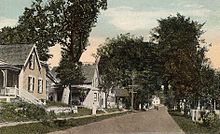
 Street scene c. 1912
As of the census of 2000, there were 1,739 people, 710 households, and 445 families residing in Meredith village, a census-designated place (CDP). The population density was 1,148.0 people per square mile (444.7/km²). There were 832 housing units at an average density of 212.7 persons/km² (549.3 persons/sq mi). The racial makeup of the town was 97.12% White, 0.40% African American, 0.46% Native American, 0.58% Asian, 0.17% from other races, and 1.27% from two or more races. 0.52% of the population were Hispanic or Latino of any race.
There were 710 households out of which 31.3% had children under the age of 18 living with them, 43.1% were married couples living together, 14.9% have a woman whose husband does not live with her, and 37.2% were non-families. 30.3% of all households were made up of individuals and 11.7% had someone living alone who was 65 years of age or older. The average household size was 2.31 and the average family size was 2.83.
In the CDP the population was spread out with 23.8% under the age of 18, 7.1% from 18 to 24, 29.3% from 25 to 44, 21.7% from 45 to 64, and 18.1% who were 65 years of age or older. The median age was 39 years. For every 100 females there were 89.6 males. For every 100 females age 18 and over, there were 86.6 males.
The median income for a household is $35,298, and the median income for a family was $42,292. Males had a median income of $32,679 versus $23,750 for females. The per capita income for the town was $18,903. 4.6% of the population and 4.3% of families were below the poverty line. Out of the total people living in poverty, 6.5% are under the age of 18 and 7.5% are 65 or older.
Education
Meredith's Inter-Lakes High School is home to the Inter-Lakes Community Auditorium, which plays host to The Summer Theatre in Meredith Village (formerly the Lakes Region Summer Theater) every summer.
Notable inhabitants
 Original SS Mount Washington (1872-1939)
- Bradford Anderson, actor
- Samuel Newell Bell, congressman
- Charles A. Busiel, manufacturer and politician
- Joseph Libbey Folsom, army officer and real estate investor
- George G. Fogg, senator and diplomat
- Dudley Leavitt, publisher
- Bob Montana, illustrator of Archie Comics
- George Orton, Canadian middle-distance runner
- Eben Ezra Roberts, architect
- Daniel E. Somes, congressman
Sites of interest
 Ridgefield Farm in 1917
- Museums
- Regional theatres and summer stock
- The Summer Theatre in Meredith Village
- In 2008 the Winnipesaukee Playhouse purchased the former Annalee Dolls factory in Meredith.[4] There are plans to move the theater from its current site in Weirs Beach to the site of the former Annalee gift shop.
- Orchestras
- Islands
- Other
- Restaurants
- Hart's Turkey Farm
References
- ^ United States Census Bureau, American FactFinder, 2010 Census figures. Retrieved March 23, 2011.
- ^ United States Census Bureau, American FactFinder, 2010 Census figures. Retrieved March 23, 2011.
- ^ "Geographic Identifiers: 2010 Demographic Profile Data (G001) - Meredith town, New Hampshire". U.S. Census Bureau American Factfinder. http://factfinder2.census.gov. Retrieved November 7, 2011.
- ^ "Annalee property sold for playhouse". New Hampshire Business Review. 2008-02-01. http://www.allbusiness.com/real-estate/commercial-residential-property-commercial/7304094-1.html. Retrieved 2008-08-09.
Further reading
- History of Meredith, Belknap County, New Hampshire 1885
- A. J. Coolidge & J. B. Mansfield, A History and Description of New England, Boston, Massachusetts 1859
External links
- Town website
- Meredith Public Library
- Meredith Chamber of Commerce
- Greater Meredith Program, a community development organization
- New Hampshire Economic and Labor Market Information Bureau Profile
- Vital Records of Meredith and other NH Towns
Municipalities and communities of Belknap County, New Hampshire City 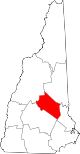
Towns Alton | Barnstead | Belmont | Center Harbor | Gilford | Gilmanton | Meredith | New Hampton | Sanbornton | Tilton
Villages Alton Bay | Center Barnstead | Gilmanton Ironworks | Glendale | Lakeport | Lochmere | Tilton-Northfield‡ | Weirs Beach
Footnotes ‡This populated place also has portions in an adjacent county or counties
Categories:- Towns in Belknap County, New Hampshire
- Populated places established in 1768


Wikimedia Foundation. 2010.