- Gorham, New Hampshire
-
Gorham, New Hampshire — Town — Location in Coos County, New Hampshire
Coordinates: 44°23′16″N 71°10′23″W / 44.38778°N 71.17306°WCoordinates: 44°23′16″N 71°10′23″W / 44.38778°N 71.17306°W Country United States State New Hampshire County Coos Incorporated 1836 Government – Board of Selectmen Paul Robitaille, Chair
David Graham
Terry OliverArea – Total 32.3 sq mi (83.7 km2) – Land 31.9 sq mi (82.6 km2) – Water 0.4 sq mi (1.1 km2) 1.27% Elevation 794 ft (242 m) Population (2010) – Total 2,848 – Density 88.2/sq mi (34/km2) Time zone Eastern (UTC-5) – Summer (DST) Eastern (UTC-4) ZIP code 03581 Area code(s) 603 FIPS code 33-30260 GNIS feature ID 0873607 Website www.gorhamnh.org Gorham is a town in Coos County, New Hampshire, United States. The population was 2,848 at the 2010 census.[1] Gorham is located in the White Mountains, and parts of the White Mountain National Forest are in the south and northwest. Moose Brook State Park is in the west. The town is crossed by the Appalachian Trail. Tourism is a principal business. It is part of the Berlin, NH–VT Micropolitan Statistical Area.
The primary settlement in Gorham, where 1,600 people resided at the 2010 census,[1] is defined as the Gorham census-designated place and is located between the two intersections of US 2 and NH 16, along the Androscoggin River.
Contents
History
The community was first chartered in 1770 by Colonial Governor John Wentworth as a part of Shelburne, called Shelburne Addition. Settled about 1805, for years it contained little more than rocky farms, small logging operations, and a few stores and stables. When incorporated in 1836, the town had only 150 inhabitants. It was named Gorham at the suggestion of Sylvester Davis, a resident from Gorham, Maine, and a relative of the Gorham family which founded that town in 1764.
The St. Lawrence and Atlantic Railroad (later the Grand Trunk Railway) arrived in 1851. Located halfway between Montreal, Canada and the seacoast, Gorham developed into a railroad town, with a major locomotive yard and repair facility. With trains came tourists, and the Mount Madison House, Alpine House, Gorham House and Willis House opened. Crowds went from Boston and the seacoast to White Mountain Station, and from there to the Glen House in Pinkham Notch and Mount Washington. In 1861, travelers made the first trek up the Mount Washington Carriage Road, winding 8 miles (13 km) to the summit of the 6,288-foot (1,917 m) mountain. "The Road to the Sky" was an engineering feat of its day, advertised as "the first man-made attraction in the United States." It would be renamed the Mount Washington Auto Road, and remains popular today.
Railroads benefited local industries as well, hauling freight for mills run by water power from the Androscoggin River. Logging flourished, with boards and building timber manufactured by the Libby and the Peabody lumber companies. That business would eventually decline, as would railroads. In 1973, the town's train depot, built in 1907, was scheduled for demolition. The Gorham Historical Society saved the building, which now serves as a headquarters and museum. It features displays on area history, with a collection including locomotives, boxcars and a caboose.
-
Exchange Street in 1908
-

The Mount Madison House c. 1912
-

View from Mount Madison House c. 1912
-

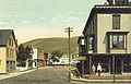
Main Street c. 1908
Geography
According to the United States Census Bureau, the town has a total area of 32.3 square miles (84 km2), of which 31.9 sq mi (83 km2) is land and 0.4 sq mi (1.0 km2) is water, comprising 1.27% of the town. The town center (census-designated place) has a total area of 0.9 sq mi (2.3 km2), of which approximately 0.9 sq mi (2.3 km2) is land and approximately 0.1 sq mi (0.26 km2) is water.
Gorham is drained by the Androscoggin, Peabody, and Moose rivers. Gorham lies fully within the Androscoggin River watershed.[2]
The highest point in Gorham is along its western border, on a spur of Mount Madison, where the elevation reaches 3,030 feet (920 m) above sea level. While Gorham itself is surrounded by larger mountains, a small prominent peak within the town is 2,400-foot (730 m) high Pine Mountain.
Demographics
 Panoramic View in 1888
As of the census[3] of 2000, there were 2,895 people, 1,293 households, and 801 families residing in the town. The population density was 90.7 people per square mile (35.0/km²). There were 1,482 housing units at an average density of 46.4 per square mile (17.9/km²). The racial makeup of the town was 97.34% White, 0.07% Black or African American, 0.21% Native American, 1.21% Asian, 0.03% Pacific Islander, 0.14% from other races, and 1.00% from two or more races. Hispanic or Latino of any race were 0.31% of the population.
There were 1,293 households out of which 26.6% had children under the age of 18 living with them, 51.7% were married couples living together, 6.5% had a female householder with no husband present, and 38.0% were non-families. 33.0% of all households were made up of individuals and 17.9% had someone living alone who was 65 years of age or older. The average household size was 2.24 and the average family size was 2.84.
 Cascade Mill c. 1920
In the town the population was spread out with 22.1% under the age of 18, 5.9% from 18 to 24, 27.9% from 25 to 44, 24.5% from 45 to 64, and 19.6% who were 65 years of age or older. The median age was 42 years. For every 100 females there were 97.2 males. For every 100 females age 18 and over, there were 94.8 males.
The median income for a household in the town was $32,250, and the median income for a family was $41,008. Males had a median income of $34,659 versus $20,278 for females. The per capita income for the town was $16,649. About 3.9% of families and 7.0% of the population were below the poverty line, including 6.0% of those under age 18 and 10.7% of those age 65 or over.
Town center
 Gorham Fire Department, 2009.
As of the census[3] of 2000, there were 1,773 people, 799 households, and 488 families residing in the town center, or census-designated place (CDP). The population density was 2,073.5 people per square mile (796.0/km²). There were 912 housing units at an average density of 1,066.6 per square mile (409.4/km²). The racial makeup of the CDP was 97.18% White, 0.06% Black or African American, 0.17% Native American, 1.02% Asian, 0.23% from other races, and 1.35% from two or more races. Hispanic or Latino of any race were 0.39% of the population.
There were 799 households out of which 24.9% had children under the age of 18 living with them, 50.6% were married couples living together, 6.8% had a female householder with no husband present, and 38.9% were non-families. 33.3% of all households were made up of individuals and 16.1% had someone living alone who was 65 years of age or older. The average household size was 2.21 and the average family size was 2.81.
In the CDP the population was spread out with 21.2% under the age of 18, 6.8% from 18 to 24, 28.2% from 25 to 44, 24.8% from 45 to 64, and 19.1% who were 65 years of age or older. The median age was 41 years. For every 100 females there were 97.0 males. For every 100 females age 18 and over, there were 97.3 males.
The median income for a household in the CDP was $31,813, and the median income for a family was $39,400. Males had a median income of $32,217 versus $22,708 for females. The per capita income for the CDP was $16,910. About 4.7% of families and 8.0% of the population were below the poverty line, including 9.8% of those under age 18 and 11.7% of those age 65 or over.
Education
Sites of interest
References
- ^ a b United States Census Bureau, American FactFinder, 2010 Census figures. Retrieved March 23, 2011.
- ^ Foster, Debra H.; Batorfalvy, Tatianna N.; and Medalie, Laura (1995). Water Use in New Hampshire: An Activities Guide for Teachers. U.S. Department of the Interior and U.S. Geological Survey. http://nh.water.usgs.gov/Publications/nh.intro.html.
- ^ a b "American FactFinder". United States Census Bureau. http://factfinder.census.gov. Retrieved 2008-01-31.
External links
- Town of Gorham official website
- New Hampshire Economic and Labor Market Information Bureau Profile
- Berlin New Hampshire History - Bordering Towns
Municipalities and communities of Coös County, New Hampshire City 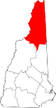
Towns Carroll | Clarksville | Colebrook | Columbia | Dalton | Dummer | Errol | Gorham | Jefferson | Lancaster | Milan | Northumberland | Pittsburg | Randolph | Shelburne | Stark | Stewartstown | Stratford | Whitefield
Townships Atkinson and Gilmanton Academy Grant | Bean's Grant | Bean's Purchase | Cambridge | Chandler's Purchase | Crawford's Purchase | Cutt's Grant | Dix's Grant | Dixville | Erving's Location | Green's Grant | Hadley's Purchase | Kilkenny | Low and Burbank's Grant | Martin's Location | Millsfield | Odell | Pinkham's Grant | Sargent's Purchase | Second College Grant | Success | Thompson and Meserve's Purchase | Wentworth's Location
Villages Bretton Woods | Cascade | Dixville Notch | Groveton | Twin Mountain | West Stewartstown
Categories:- Towns in Coos County, New Hampshire
- Berlin micropolitan area
-


Wikimedia Foundation. 2010.