- Londonderry, New Hampshire
-
Londonderry, New Hampshire — Town — 
SealLocation in Rockingham County, New Hampshire
Coordinates: 42°51′54″N 71°22′26″W / 42.865°N 71.37389°WCoordinates: 42°51′54″N 71°22′26″W / 42.865°N 71.37389°W Country United States State New Hampshire County Rockingham Incorporated 1722 Government – Town council Sean O'Keefe, Chairman
George "Tom" Dolan
John Farrell
Joe Green
Tom FredaArea – Total 41.9 sq mi (108.6 km2) – Land 41.8 sq mi (108.3 km2) – Water 0.1 sq mi (0.3 km2) 0.31% Elevation 420 ft (128 m) Population (2010) – Total 24,129 – Density 575.9/sq mi (222.3/km2) Time zone Eastern (UTC-5) – Summer (DST) Eastern (UTC-4) ZIP code 03053 Area code(s) 603 FIPS code 33-43220 GNIS feature ID 0873651 Website www.londonderrynh.org Londonderry is a town in western Rockingham County, New Hampshire, United States. The town is bordered on the north by the city of Manchester and on the east by the town of Derry. The population was 24,129 at the 2010 census.[1] Londonderry is known for its apple orchards and is partial home to Manchester-Boston Regional Airport.
The more densely settled portion of town, where 11,037 people resided at the 2010 census,[2] is defined as the Londonderry census-designated place (CDP) and roughly occupies the eastern and southern parts of town, around New Hampshire Route 102.
Contents
History
Londonderry lies in an area that was first known as "Nutfield" because of the dense woods with nut trees. The town was settled in 1718 by Scots-Irish settlers, many of whom had left their homes in Londonderry in the Province of Ulster in the north of Ireland, and arrived in Boston in 1718 to start a new life without religious wars and persecution. In 1722, the town was chartered and given the name "Londonderry".[3][4]
Early Ulster Scots settlers spread out into surrounding villages, bringing Scottish and Irish names like Antrim, Derry and Dunbarton. Londonderry was the second largest town in early colonial times, and Derry, Windham and a portion of Manchester were formed from it.
In 1719, the first American potato was grown in Derry, then a part of Londonderry.
In 1790, the first year that a census was taken in Londonderry, the population was 2,622.
Antique postcards
-

Civil War Soldiers' Monument c. 1905
-

Railroad Station in 1914
-

Col. W. S. Pillsbury residence c. 1910
Geography
According to the United States Census Bureau, the town has a total area of 41.9 square miles (108.5 km2), of which 41.8 sq mi (108.3 km2) is land and 0.1 sq mi (0.3 km2) is water, comprising 0.31% of the town. The census-designated place portion of Londonderry has a total area of 12.2 sq mi (32 km2), of which 0.16% is water.
Londonderry is drained on the east by Beaver Brook and on the west by Little Cohas Brook and Nesenkeag Brook. The town's highest point is 535 feet (163 m) above sea level, on "Number Eight Hill" (named after the old school house that used to be on it) north of the center of town.
The town is crossed by Interstate 93, New Hampshire Route 102, New Hampshire Route 128, and New Hampshire Route 28.
Neighboring cities and towns

Manchester Manchester Auburn Litchfield 
Derry  Londonderry

Litchfield Hudson Windham Demographics
As of the census[5] of 2000, there were 23,236 people, 7,623 households, and 6,319 families residing in the town. The population density was 555.8 people per square mile (214.6/km²). There were 7,718 housing units at an average density of 184.6 per square mile (71.3/km²). The racial makeup of the town was 96.92% White, 0.56% Black or African American, 0.17% Native American, 1.16% Asian, 0.03% Pacific Islander, 0.32% from other races, and 0.84% from two or more races. Hispanic or Latino of any race were 1.53% of the population.
There were 7,623 households out of which 50.3% had children under the age of 18 living with them, 70.9% were married couples living together, 8.6% had a female householder with no husband present, and 17.1% were non-families. 12.9% of all households were made up of individuals and 3.3% had someone living alone who was 65 years of age or older. The average household size was 3.05 and the average family size was 3.36.
In the town the population was spread out with 32.9% under the age of 18, 5.8% from 18 to 24, 32.7% from 25 to 44, 23.2% from 45 to 64, and 5.3% who were 65 years of age or older. The median age was 35 years. For every 100 females there were 97.0 males. For every 100 females age 18 and over, there were 95.1 males.
The median income for a household in the town was $70,501, and the median income for a family was $73,513. Males had a median income of $50,566 versus $33,821 for females. The per capita income for the town was $26,491. About 1.6% of families and 2.1% of the population were below the poverty line, including 1.2% of those under age 18 and 6.3% of those age 65 or over.
Census-designated place
As of the census[5] of 2000, there were 11,417 people, 3,832 households, and 3,130 families residing in the CDP occupying the eastern and southern parts of town. The population density was 936.0 people per square mile (361.3/km²). There were 3,881 housing units at an average density of 318.2 per square mile (122.8/km²). The racial makeup of the CDP was 97.22% White, 0.50% Black or African American, 0.15% Native American, 0.93% Asian, 0.04% Pacific Islander, 0.21% from other races, and 0.95% from two or more races. Hispanic or Latino of any race were 1.52% of the population.
There were 3,832 households out of which 48.3% had children under the age of 18 living with them, 67.7% were married couples living together, 10.3% had a female householder with no husband present, and 18.3% were non-families. 13.8% of all households were made up of individuals and 3.5% had someone living alone who was 65 years of age or older. The average household size was 2.98 and the average family size was 3.30.
In the CDP the population was spread out with 32.0% under the age of 18, 6.4% from 18 to 24, 31.8% from 25 to 44, 24.0% from 45 to 64, and 5.8% who were 65 years of age or older. The median age was 35 years. For every 100 females there were 95.0 males. For every 100 females age 18 and over, there were 92.8 males.
The median income for a household in the CDP was $68,707, and the median income for a family was $71,484. Males had a median income of $50,184 versus $31,998 for females. The per capita income for the CDP was $26,767. About 1.5% of families and 2.3% of the population were below the poverty line, including 1.6% of those under age 18 and 4.0% of those age 65 or over.
Economy
Londonderry is home to numerous businesses, many of which are located in the northern part of the town near Manchester-Boston Regional Airport (MHT), or in the southeastern part of town near I-93, on NH 102. Major businesses headquartered in town include Stonyfield Farm and Blue Seal Feeds; also a bottling facility of the Coca-Cola Bottling Co. is located in town. Mack's Apples, Sunnycrest Farm, Elwood Orchards, and Woodmont Orchards are among the several orchards in town and are emblematic of the town's important farming heritage. The town is also home to numerous chain retailers.
Education
The town is served by the Londonderry School District.
Kindergarten:
- Moose Hill School (includes LEEP, the Londonderry Early Education Program)
Elementary Schools:
- North School
- Matthew Thornton Elementary School
- South School
Middle School:
- Londonderry Middle School
High School:
- Londonderry High School (home of the Lancers), known for its exceptional marching band program, which traveled to China in the summer of 2008 to participate in pre-ceremonies for the Olympic Games.
Private Schools:
- Victory Baptist School (K-12)
- Adventures in Learning
- Applewood Learning Center
- Cozy Kid's Child Care
- Kindercare
- Pixie Preschool I
- Winnie's Creative Kindergarten
Religion
Londonderry is well served by a vibrant community of religious institutions of various faiths and practices.
- Baptist
- Christian Fellowship Baptist Church
- Londonderry Baptist Church
- Slavic Baptist Church
- Victory Baptist Church (Independent)
- Catholic
- St. Jude Parish
- St. Mark the Evangelist Catholic Church
- Episcopal
- St. Peter's Episcopal
- Methodist
- Korean Methodist Church of NH
- Londonderry United Methodist Church
- Nazarene
- Journey Church
- Presbyterian
- Londonderry Presbyterian Church
- Other Christian
- Jehovah's Witnesses
- Church of the King
- Granite State Church of Christ
- Londonderry Christian Church
- Orchard Christian Fellowship
- Trinity Bible Church
- Jewish
- Etz Hayim Synagogue
Notable inhabitants
- Ant (comedian), host of VH1 reality series Celebrity Fit Club
- John Bell, governor of New Hampshire
- Samuel Bell, governor of New Hampshire
- Silas Betton, congressman
- Dominic DiMaggio, Boston Red Sox outfielder
- John Fisher, industrialist and politician
- Arthur Livermore, congressman
- Joseph McKeen, president of Bowdoin College
- Dan Mullen, college football coach
- Ocean Born Mary, folklore legend
- William M. Oliver, congressman
- Ethan Paquin, poet
- Peter Patterson, businessman and politician
- George Reid, Revolutionary War officer
- Laura Silva, beauty queen
- William Stark, Revolutionary War officer
- Samuel Taggart, congressman
- Brian Wilson, San Francisco Giants pitcher
- James Wilson, globe maker
Sister cities
Site of interest
References
- ^ United States Census Bureau, American FactFinder, 2010 Census figures. Retrieved March 23, 2011.
- ^ United States Census Bureau, American FactFinder, 2010 Census figures. Retrieved March 23, 2011.
- ^ "The Early History of Londonderry". Londonderry Historical Society. http://www.londonderryhistory.org/townhist. Retrieved March 22, 2010.
- ^ "The History of Londonderry" The History of Londonderry by Rev Edward L. Parker page 60
- ^ a b "American FactFinder". United States Census Bureau. http://factfinder.census.gov. Retrieved 2008-01-31.
Further reading
- Rev. Edward L. Parker, History of Londonderry, Comprising the Towns of Londonderry and Derry; Perkins & Whipple; Boston 1851
- A. J. Coolidge & J. B. Mansfield, A History and Description of New England; Boston, Massachusetts 1859
External links
- Town website
- Town economic development website
- Leach Library
- Londonderry School District
- Londonderry Times - Hometown Newspaper
- Londonderry Hometown Online News
- New Hampshire Economic and Labor Market Information Bureau Profile
Municipalities and communities of Rockingham County, New Hampshire City 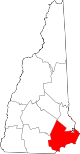
Towns Atkinson | Auburn | Brentwood | Candia | Chester | Danville | Deerfield | Derry | East Kingston | Epping | Exeter | Fremont | Greenland | Hampstead | Hampton | Hampton Falls | Kensington | Kingston | Londonderry | New Castle | Newfields | Newington | Newmarket | Newton | North Hampton | Northwood | Nottingham | Plaistow | Raymond | Rye | Salem | Sandown | Seabrook | South Hampton | Stratham | Windham
Villages Candia Four Corners | East Candia | East Derry | East Hampstead | Hampton Beach | Seabrook Beach
Categories:- Towns in Rockingham County, New Hampshire
- Populated places established in 1722
-


Wikimedia Foundation. 2010.