- Niskayuna, New York
-
Niskayuna — Town — Nickname(s): Nisky Location within Schenectady County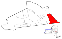 Location within the state of New York
 Niskayuna
Coordinates: 42°48′1″N 73°52′51″W / 42.80028°N 73.88083°WCoordinates: 42°48′1″N 73°52′51″W / 42.80028°N 73.88083°W Country United States State New York County Schenectady Area – Total 15.0 sq mi (39.0 km2) – Land 14.1 sq mi (36.5 km2) – Water 0.9 sq mi (2.4 km2) Elevation 404 ft (123 m) Population (2000) – Total 20,295 – Density 1,438.3/sq mi (555.3/km2) Time zone Eastern (EST) (UTC-5) – Summer (DST) EDT (UTC-4) [[ZIProxy-Connection: keep-alive Cache-Control: max-age=0
code]]12309 Area code(s) 518 FIPS code 36-51264 GNIS feature ID 0979279 Niskayuna is a town in Schenectady County, New York. The population was 20,295 at the 2000 census. The town is located in the southeast part of the county, north and east of the city of Schenectady, and is the easternmost town in the county
Contents
History
Niskayuna was formed on March 7, 1809 with an original population of 681. The name of town was derived from the term "Nis-ti-go-wo-ne" or "Co-nis-tig-i-one." The original meanings of the words translate roughly as "extensive corn flats."[1]
Tradition has preserved a few of the following names of the chiefs of the Connestigiune tribe who inhabited this section of the country: Ron-warrigh-woh-go-wa, (signifying in English, the great fault finder or grumbler), Ka-na-da-rokh-go-wa, (signifying a great eater), Ro-ya-na, (a chief), As-sa-ve-go, (big knife), and A-voon-ta-go-wa, (big tree). Of these, the first made the greatest objection to alienating lands to the whites and in each deed he was careful to have a covenant inserted by which the rights of hunting and fishing were preserved to them. It was a common saying of his that "after the whites had taken possession of our lands, they will make Kaut-sore (literally spoon-food or soup) of our bodies." Yet he was on the most friendly terms with the whites and was never backward in extending to them his powerful influence and personal aid during their expedition against the Canadians in the French War. He took great delight in instructing the boys of the settlers in the arts of war and was constantly complaining that the government did not prosecute the war against the French with sufficient vigor. The council fire of the Connestigiune band was held about a mile south of the village.
In 1687, Niskayuna was visited by a spy from the Adirondack tribe, which was an ally of the French. Hunger drove him to the house of a Dutchman by the name of Van Brakle, where he devoured an enormous quantity of the food set before him, which happened to be pork and peas. Although his movements had been made with unusual caution, the eagle eye of the "Grumbler" detected him. He waylaid him on leaving the house of his entertainer and after a short conflict, killed him. Having severed the head of the corpse from the body, he repaired to the house of Van Brakle and threw the head into the window, exclaiming to the owner: "Behold the head of your pea eater." [2]
The first settlers of this town were an independent class of Hollanders who located outside the manor line to avoid the conflicting exactions of the patrons and the trading government of the New Netherlands. It was settled at about the same time as was Schenectady.
Among the early settlers were the Clutes, Craigs, Van Vrankens, Vedders, Vroomans, Groots, Tymersons, Consauls, Pearses, Van Brookhovens, Claases, Jansens, and Kriegers. From an old document it appears that Harmon Vedder obtained a patent for some land here in 1664.
Captain Martin Cregier, who was the first burgomaster of New Amsterdam, finally settled in Niskayuna, on the banks of the Mohawk, "where the Indians carry their canoes across the stones." In this retired and romantic spot, this brave soldier and just magistrate died in the year 1712.[3]
The Knolls Atomic Power Laboratory was opened here in 1946. In 1973, the General Electric Engineering Development Center moved from downtown Schenectady to River Rd in Niskayuna. Today, it is the world headquarters of the four GE Global Research Centers.
In 2008 a massive ice storm left much of the town in the dark for one to five days and caused a million dollars of damage to property, including several old growth trees.
The following sites are listed on the National Register of Historic Places:[4] George Westinghouse Jones House, Niskayuna Railroad Station, Niskayuna Reformed Church, and Rosendale Common School.
Geography
The northern and eastern town lines are defined by the Mohawk River with Saratoga County, New York on the opposite bank. The south town line is the town of Colonie in Albany County, New York. The town borders the city of Schenectady to the west.
According to the United States Census Bureau, the town has a total area of 15.1 square miles (39.0 km²), of which, 14.1 square miles (36.5 km²) of it is land and 0.9 square miles (2.4 km²) of it (6.25%) is water.
Niskayuna previously received the designation of Tree City USA [5] though it is not listed on the current Tree City USA roster.[6]
Demographics
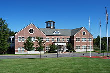 Niskayuna town hall
As of the census[7] of 2000, there were 20,295 people, 7,787 households, and 5,793 families residing in the town. The population density was 1,438.3 people per square mile (555.3/km²). There were 8,046 housing units at an average density of 570.2 per square mile (220.2/km²). The town's population was 51.7% female and 48.3% male. The racial makeup of the town was 90.7% White, 6.0% Asian, 1.6% African-American, and 1.6% "Other."[1]
There were 7,787 households out of which 36.2% had children under the age of 18 living with them, 64.2% were married couples living together, 7.6% had a female householder with no husband present, and 25.6% were non-families. 22.1% of all households were made up of individuals and 11.5% had someone living alone who was 65 years of age or older. The average household size was 2.56 and the average family size was 3.02.
In the town the population was spread out with 26.1% under the age of 18, 4.2% from 18 to 24, 25.4% from 25 to 44, 27.1% from 45 to 64, and 17.1% who were 65 years of age or older. The median age was 42 years. For every 100 females there were 93.3 males. For every 100 females age 18 and over, there were 87.8 males.
The median income for a household in the town was $70,800, and the median income for a family was $79,539. Males had a median income of $59,738 versus $39,692 for females. The per capita income for the town was $33,257. The average family income in Niskayuna is the highest in the Capital District.[2]
"Niska-Day": an Annual Community Holiday
Established in 1980 by the Niskayuna Community Action Program (N-CAP) in response to a school district report on mental health needs, "Niska-Day" is traditionally celebrated on the second Saturday of May. The festival begins in the early morning with a family foot race. This is followed by a parade and a fair. The day concludes with fireworks (weather permitting). Each year sees the selection of a new theme (e.g., in 2007: "Niska-unity"), and the day aims in general to bring the town's families together for a celebration that will help them recognize and appreciate their shared identity as residents of the town of Niskayuna.[8] New residents sometimes express surprise that, unlike many municipalities, the town of Niskayuna does not sponsor an official observation of the Fourth of July.[9] "Niska-Day" serves as the local substitute.[10]
Communities and locations in Niskayuna
- Aqueduct – A hamlet at the northern tip of the town.
- Avon Crest – A large suburban development south of Troy-Schenectady Road.
- Avon Crest North – An extension of Avon Crest to the north of Troy-Schenectady Road.
- Catherine's Woods Estates – A small neighborhood on the east side of the town near the Mohawk River.
- Edison Woods – A small, newer, upscale suburban development near the Knolls Atomic Power Laboratory.
- Forest Oaks – A small, upscale development off Pearse Road which borders Albany County.
- Niska Isle – A peninsula along the Mohawk River
- Hawthorne Hill – A suburban community east of Schenectady.
- Hexam Gardens - a small development between Balltown Rd, Rt. 7, and the Reist Bird Sanctuary.
- Karen Crest – A small development in southwestern part of town near Hillside School.
- Niskayuna – A census-designated place and hamlet in the southeast part of the town.
- "Old Niskayuna" – The area of the town west of Balltown Road and north of Union Street. The term is a misnomer; "Old Niskayuna" is actually the Niskayuna hamlet at the east end of town that once extended well into what is now the Town of Colonie.
- Orchard Park – A small neighborhood situated between GE Global Research and Niskayuna High School and bordered by Balltown Road on the west and River Road to the north.
- Rosendale Estates – A large suburban development in the central part of the town near Rosendale Elementary school and Iroquois Middle School.
- Stanford Heights – A hamlet in the southwest corner of the town that contains a historic mansion once owned by the parents of Leland Stanford and then later by their son Charles Stanford.
- Grand Blvd Estates – A neighborhood on either side of the tree-lined Grand Boulevard mall. Its center mall was once the route of a main trolley line from the Hillside Avenue trolley barns to downtown Schenectady.
- Windsor Estates – Another small, upscale development near GE Global Research and the Knolls Atomic Power Laboratory(KAPL). The front entrance leads to Van Antwerp Road, the Niskayuna High School, and Town Hall, while the back entrance leads to River Road.
Notable residents
- Jeff Blatnick – wrestler, Olympic gold medalist
- André Davis – NFL wide receiver
- Ivar Giaever – physicist, 1972 Nobel laureate
- Steve Katz, musician, Blues Project, Blood, Sweat and Tears
- Maureen O'Sullivan (1911-1998) – actress, mother of Mia Farrow
- Ron Rivest – cryptographer, co-inventor of the RSA encryption algorithm
Notes
- ^ "Niskayuna Since 1640". http://www.niskayuna.org/Public_Documents/NiskayunaNY_Historian/history2.
- ^ Howell. "History of the Township of Niskayuna". History of the county of Schenectady, N.Y., from 1662 to 1886: Its to the Close of the Nineteenth Century. http://books.google.com/books?id=eWThMMumH2QC&lpg=PA192&dq=%22behold%20the%20head%20of%20your%20pea%20eater%22&pg=PA192#v=onepage&q=&f=false.
- ^ Austin A. Yates (1902). "Towns of the County". Schenectady County, New York: Its History to the Close of the Nineteenth Century. New York History Company. http://www.schenectadyhistory.org/resources/yates/27.html#nis.
- ^ "National Register Information System". National Register of Historic Places. National Park Service. 2009-03-13. http://nrhp.focus.nps.gov/natreg/docs/All_Data.html.
- ^ "Tree City USA, NY Department of Environmental Conservation". http://www.dec.ny.gov/lands/5272.html.
- ^ "Arbor Day Foundation listing of current "Tree City USA" winners". http://www.arborday.org/programs/treeCityUSA/treecities.cfm?chosenstate=New_York.
- ^ "American FactFinder". United States Census Bureau. http://factfinder.census.gov. Retrieved 2008-01-31.
- ^ "The History of Niska-Day.". http://www.niskaday.org/History.html. Retrieved May 21, 2009.
- ^ "Website for the Town of Niskayuna.". http://www.niskayuna.org/Public_Documents/index. Retrieved May 21, 2009.
- ^ "'It's not the Fourth of July yet...it's Niska-Day!'.". http://www.spotlightnews.com/spotlightnews/article.php?article_id=tD1210189984t482208a027122. Retrieved May 21, 2009.
External links
Municipalities and communities of Schenectady County, New York City 
Towns Duanesburg | Glenville | Niskayuna | Princetown | Rotterdam
Villages CDPs Other
hamletCapital District of New York Central communities Albany (History · City Hall · Coat of Arms) · Schenectady (City Hall) · Troy (History) · List of all incorporated places
Largest communities
(over 20,000 in 2000)Bethlehem · Clifton Park · Town of Colonie · Glenville · Guilderland · Niskayuna · Queensbury · Rotterdam · Saratoga SpringsMedium-sized communities
(10,000 to 20,000 in 2000)City of Amsterdam · Brunswick · Cohoes · East Greenbush · Glens Falls · Gloversville · Halfmoon · Malta · North Greenbush · Schodack · Watervliet · WiltonSmall communities
(5,000 to 10,000 in 2000)Town of Amsterdam · Ballston Spa · Cobleskill · Village of Colonie · Duanesburg · City of Johnstown · Town of Johnstown · Kinderhook · Mechanicville · New Scotland · Rensselaer · Sand Lake · Scotia · Town of Stillwater · WaterfordCounties Albany · Columbia · Fulton · Greene · Montgomery · Rensselaer · Saratoga · Schenectady · Schoharie · Warren · WashingtonHistory Mohawks · Mahicans · Fort Orange · Rensselaerswyck · Beverwyck · Albany Plan of Union · Timeline of town creation · Toponymies of places · Tech ValleyGeography Hudson River (Valley) · Mohawk River · Erie Canal · Lake Albany · Lake George · Albany Pine Bush (Rensselaer Lake · Woodlawn Preserve) · Adirondack Mountains · Catskill Mountains · Rensselaer PlateauReligion and culture Culture in New York's Capital District · Sports in New York's Capital District · Episcopal Diocese of Albany · Roman Catholic Diocese of AlbanyEducation Public school districtsList of school districts in New York's Capital DistrictHigher educationNewspapers TV/Radio Broadcast television in the Capital District Local stations WRGB (6.1 CBS, 6.2 This TV) • WTEN (10.1 ABC, 10.2 Weather, 10.3 RTV) • WNYT (13.1 NBC, 13.2 Weather, 13.3 Weather Radar) • WMHT (17.1 PBS, 17.2 ThinkBright, 17.3 HD) • WXXA (23.1 Fox, 23.2 The Cool TV) • WNGN-LP 35 / WNGX-LP 42 (FN) • WCWN (45.1 The CW, 45.2 Uni Sp) • WNYA / WNYA-CD (51.1 MNTV, 51.2 Antenna TV) • W52DF 52 (silent)
Outlying area stations WVBK-CA 2 (RSN' Manchester, VT) • W04AJ 4 (PBS; Glens Falls) • W04BD 4 (PBS; Schoharie) •
WNCE-CA 8 (A1; Glens Falls) • WYBN-CA 14 (RSN; Cobleskill) • WCDC (19.1 ABC; Adams, MA) • WVBG-LP 25 (RSN; Greenwich) • W36AX 36 (PBS / VPT; Manchester, VT) • W47CM 47 (silent; Glens Falls) • WYPX (55.1 Ion, 55.2 qubo, 55.3 Life; Amsterdam) • W53AS 53 (PBS / VPT; Bennington, VT)Adjacent locals Cable-only stations YNN Capital Region • TW3 • YES • SNY • MSG Network
Defunct stations New York State television: Albany/Schenectady • Binghamton • Buffalo • Burlington/Plattsburgh • Elmira • New York City • Rochester • Syracuse • Utica • Watertown
Vermont Broadcast television: Albany/Schenectady • Boston, MA • Burlington/Plattsburgh
Massachusetts television: Albany • Boston • Providence • Springfield
Radio stations in the Albany / Schenectady / Troy market by FM frequency 88.3 · 89.1² · 89.7 · 89.9 · 90.3/93.1² · 90.7/94.9 · 90.7 · 90.7 · 90.9 · 91.1 · 91.5 · 92.3 · 92.9 · 93.5 · 93.7 · 94.5 · 94.7 · 95.5 · 95.9 · 96.3 · 96.7 · 97.3 · 97.5 · 97.7 · 97.9 · 98.3² · 98.5 · 98.5 · 99.1 · 99.5² · 100.3 · 100.9 · 101.3 · 101.7 · 101.9 · 102.3² · 102.7 · 103.1² · 103.5 · 103.9 · 104.5 · 104.9 · 105.7² · 106.1 · 106.5² · 107.1 · 107.7²by AM frequency NOAA Weather Radio frequency 162.550by callsign W226AC · W235AY · W256BU · W291BY · WABY · WAJZ · WAMC (AM) · WAMC-FM² · WBAR · WBPM · WCDB · WCKL · WCKM · WCQL · WCSS · WCTW · WDCD · WDCD-FM · WDDY² · WENT · WEQX · WEXT · WFFG · WFLY · WFNY · WGDJ · WGNA² · WGXC · WGY¹² · WGY-FM² · WHAZ · WHAZ-FM · WHUC · WHVP · WIZR · WJIV · WKBE · WKKF² · WKLI · WLJH · WMHT² · WMYY · WNYQ · WOFX² · WOPG · WPGL · WPYX² · WQAR · WQBJ · WQBK · WQSH² · WRIP · WROW · WRPI · WRUC · WRVE² · WSDE · WTMM · WTRY² · WUAM · WVCR · WVKZ · WVTL · WXL34 · WYAI · WYJB · WYKV · WZCR · WZMRDefunct stations New York Radio Markets: Albany-Schenectady-Troy • Binghamton • Buffalo-Niagara Falls • Elmira-Corning • Hamptons-Riverhead • Ithaca • Nassau-Suffolk (Long Island) • New York City • Newburgh-Middletown (Mid Hudson Valley) • Olean • Plattsburgh • Poughkeepsie • Rochester • Syracuse • Utica-Rome • Watertown
Other New York Radio Regions: Jamestown-Dunkirk • North Country • Saratoga
See also: List of radio stations in New YorkCategories:- Towns in New York
- Populated places in Schenectady County, New York
- Place names in New York of Native American origin


Wikimedia Foundation. 2010.