California State Route 136
- California State Route 136
Infobox road
state=CA
type=SR
route=136
section=436
maint=Caltrans
length_mi=18
length_round=0
length_ref= [ [http://www.dot.ca.gov/hq/structur/strmaint/brlog2.htm January 1, 2006 California Log of Bridges on State Highways] ]
direction_a=West
terminus_a=Jct|state=CA|US|395 at Lone Pine
direction_b=East
terminus_b=Jct|state=CA|SR|190 towards Death Valley
previous_type=SR
previous_route=135
next_type=SR
next_route=137
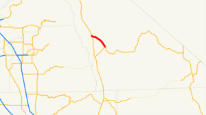
State Route 136 is a short state highway in California, USA, running from Lone Pine to State Route 190 along the northern edge of Owens Lake.
This route is part of the California Freeway and Expressway System[ [http://www.leginfo.ca.gov/cgi-bin/displaycode?section=shc&group=00001-01000&file=250-257 CA Codes (shc:250-257)] ] .]Route description
The western terminus is at U.S. Route 395 in Lone Pine. The eastern terminus is at State Route 190 which continues on to Death Valley.
Major intersections
:"Note: Except where prefixed with a letter, postmiles were measured in 1964, based on the alignment as it existed at that time, and do not necessarily reflect current mileage."
The entire route is in Inyo County.
External links
* [http://www.dot.ca.gov/hq/roadinfo/sr136 Caltrans: Route 136 highway conditions]
* [http://www.cahighways.org/129-136.html#136 California Highways: Route 136]
References
Wikimedia Foundation.
2010.
Look at other dictionaries:
California State Route 190 — State Route 190 Route information … Wikipedia
California State Route 75 — Karte … Deutsch Wikipedia
California State Route 135 — State Route 135 Route information … Wikipedia
California State Route 133 — Infobox road state=CA type=SR route=133 alternate name=Laguna Canyon Road, Laguna Freeway, length mi=13.635 length ref= length round=3 history=State highway in 1933; SR 133 in 1964 direction a=South terminus a=Jct|state=CA|SR|1 in Laguna Beach… … Wikipedia
California State Route 134 — Infobox road state=CA type=SR route=134 alternate name=Ventura Freeway section=434 maint=Caltrans length mi= 13.333 length round=0 length ref= history=1930s as a highway, 1953 as a number direction a=West terminus a=jct|state=CA|US|101|SR|170 in… … Wikipedia
California State Route 132 — Infobox road state=CA type=SR route=132 section=432 maint=Caltrans length mi=76 length round=0 length ref= [http://www.dot.ca.gov/hq/structur/strmaint/brlog2.htm January 1, 2006 California Log of Bridges on State Highways] ] direction a=West… … Wikipedia
California State Route 137 — Infobox road state=CA type=SR route=137 section=437 maint=Caltrans length mi=29 length round=0 length ref= [ [http://www.dot.ca.gov/hq/structur/strmaint/brlog2.htm January 1, 2006 California Log of Bridges on State Highways] ] direction a=West… … Wikipedia
California State Route 129 — Infobox road state=CA type=SR route=129 section=429 maint= length mi=14.095 length round=3 length ref= established=1964 direction a=West terminus a=jct|state=CA|SR|1 near Watsonville direction b=East terminus b=jct|state=CA|US|101 near San Juan… … Wikipedia
New York State Route 27 — Sunrise Highway redirects here. For the Sunrise Highway in San Diego County, California, see County Route S1 (California). NY 27 redirects here. NY 27 may also refer to New York s 27th congressional district. NYS Route 27 … Wikipedia
New York State Route 52 — This article is about the current alignment of NY 52. For the former alignment of NY 52 in the Finger Lakes region, see New York State Route 52 (1920s–1930). NYS Route 52 … Wikipedia
