- New Jersey Route 139
-
Route 139
State Highway 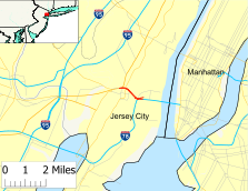
Route information Maintained by NJDOT and PANYNJ Length: 2.77 mi[1][2][3] (4.46 km) Existed: 1988 – present Major junctions West end: Upper:  CR 501 in Jersey City
Lower: US 1-9 in Jersey City
 I-78 / NJ Turnpike in Jersey City
East end: I-78 at Holland Tunnel in Jersey CityHighway system New Jersey State Highway Routes
Interstate and US←  Route 138
Route 140  →
→Route 139 is a state highway in Jersey City, New Jersey, extending the Pulaski Skyway east to the Holland Tunnel. The western portion of the route is a two level highway that is charted by the New Jersey Department of Transportation as two separate roadways: The 1.45-mile (2.33 km) lower roadway between U.S. Route 1/9 at the Tonnele Circle and Interstate 78, and the 0.83-mile (1.34 km) upper roadway running from County Route 501 (Kennedy Boulevard) to Interstate 78. The eastern 1.32 mi (2.12 km) of the route, the Holland Tunnel approach, runs concurrent with Interstate 78 on the one-way pair of 12th Street eastbound and 14th Street westbound. Including the concurrency, the total length of Route 139 is 2.77 mi (4.46 km).
What is now the upper level of Route 139 became an extension of pre-1927 Route 1 in 1922. U.S. Route 1 was also designated along the road in 1926 and a year later Route 25 replaced pre-1927 Route 1. After U.S. Route 1 was rerouted to cross the Hudson River on the George Washington Bridge, the former routing to the Holland Tunnel along Route 25 became U.S. Route 1/9 Business. In 1953, Route 25 was removed from the road in favor of the business route. By the 1990s, U.S. Route 1/9 Business was replaced by Route 139. A new freeway for Route 139 called the Bergen Arches Expressway was proposed in 1989 to connect the Jersey City Waterfront with the Meadowlands Sports Complex. This four-lane freeway, which was to follow an abandoned railroad line known as the Bergen Arches, was strongly supported by Jersey City Mayor Bret Schundler and received funding from the federal Transportation Equity Act for the 21st Century. However, the highway plan was dropped by 2002 after Schundler left office and his successors in the city government felt a mass transit proposal would work better. The 12th and 14th Street Viaducts connecting Route 139 and Interstate 78 are currently being reconstructed at a cost of $225 million; this project is expected to be complete in 2010.
Contents
Route description
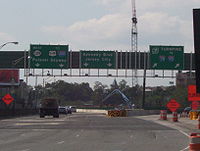 New signage and construction work at the left exit off of I-78 for Route 139. (Exit 66)
Route 139 is essentially three distinct but connected highways: the upper level, the lower level, and the Holland Tunnel approach (the Interstate 78 concurrency). NJDOT officially charts the lower and upper levels as independent highways, with the lower level considered Route 139 and the upper level considered Route 139U and a notation that the highway coincides with I-78.[1][2][3]
Lower level
The lower level of Route 139 is a four-lane freeway under Jersey City that begins at U.S. Route 1/9 at the Tonnele Circle.[1] At the Tonnele Circle, the route has ramps to both directions of U.S. Route 1/9 as well as to U.S. Route 1/9 Truck, which connects to Route 7 and Interstate 280.[4] From here, it heads east through urban neighborhoods before passing under County Route 501 (Kennedy Boulevard).[1][4] Past this bridge, the road turns to the southeast and runs under the upper level of Route 139.[4] Past Palisade Avenue, the lower level of Route 139 emerges from underground and, along with the upper level, merges into Interstate 78 at an interchange.[1][4]
Upper level
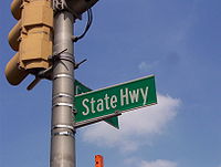 Sign designating the upper level of Route 139 as State Highway
The upper level of Route 139 (also known as State Highway and Hoboken Avenue) begins at an intersection with County Route 501 (Kennedy Boulevard), which connects to Bayonne and Union City. The road heads to the southeast through urban residential and commercial areas as a four-lane undivided road, coming to an intersection with Collard Street.[2][5] Here, the route becomes a four-lane divided road that runs above the lower level of Route 139, heading between the Heights district to the north and the Journal Square district to the south.[5] It crosses several streets, including County Route 646 (St. Pauls Avenue), County Route 617 (Summit Avenue), County Route 663 (Central Avenue), and County Route 644 (Oakland Street).[2] After intersecting a few more streets, the road meets Concord Street, where there is an eastbound left lane exit and a westbound intersection. After the intersection with Palisade Avenue and a westbound entrance from Hoboken Avenue, an upward road from Coles Street and 18th Street in Downtown Jersey City, the upper level of Route 139 merges with the lower level at an interchange with Interstate 78.[2][5]
I-78 concurrency
 Eastbound towards Holland Tunnel
The lower and upper levels of Route 139 merge at an interchange with Interstate 78, which has two viaducts along Route 139, the easbound 12th Street Viaduct and the westbound 14th Street Viaduct.[6] From here, Route 139 continues east concurrent with that route and passes through business areas as a one-way pair that follows six-lane 12th Street eastbound and six-lane 14th Street westbound. This segment of the route is under the jurisdiction of the Port Authority of New York and New Jersey and is also known as Boyle Plaza.[3][6] The first intersection is with Jersey Avenue, which heads to Downtown Jersey City and Hoboken.[6] It intersects with the one-way northbound County Route 633 (Erie Street) next before crossing one-way southbound County Route 635 (Grove Street).[3] After Grove Street, the road crosses County Route 637 (Luis Muñoz Marín Boulevard) near the Newport Centre Mall. Past this intersection, the eastbound direction comes to the toll plaza for the Holland Tunnel.[6] From here, the concurrency enters the Holland Tunnel under the Hudson River, which carries two lanes in each direction. Route 139 ends at the New Jersey/New York state line within the tunnel and Interstate 78 continues into New York City.[3][6]
History
What is now the upper level of Route 139 was originally designated as the northernmost part of pre-1927 Route 1 in 1922, a route that was to run from Trenton to Jersey City.[7] When the U.S. Highway System was established in 1926, this road was also designated as a part of U.S. Route 1.[8] In the 1927 New Jersey state highway renumbering this portion of route became a part of Route 25, a route that was to run from the Ben Franklin Bridge in Camden to the Holland Tunnel.[9][10] In 1928, the two-level portion of the road was constructed to provide a high-speed connection between the Holland Tunnel and Newark.[11] After the opening of the George Washington Bridge, U.S. Route 1 was realigned to head north along U.S. Route 9 from the Tonnele Circle to the bridge, and the former U.S. Route 1 between the Tonnele Circle and the Holland Tunnel along Route 25 became U.S. Route 1/9 Business. At the Holland Tunnel, this route connected to New York State Route 1A and New York State Route 9A.[12] In the 1953 New Jersey state highway renumbering, the Route 25 designation was dropped from the route in favor of U.S. Route 1/9 Business.[13][14] By the 1990s, U.S. Route 1/9 Business was renumbered to Route 139.[15][16]
A freeway for Route 139 called the Bergen Arches Expressway was proposed in 1989 by Governor Thomas Kean to connect the Jersey City waterfront with a new railroad line providing access to the Meadowlands Sports Complex. This proposed road, which was to be four lanes wide, was to follow an abandoned railroad line known as the Bergen Arches.[17] This proposed highway was strongly supported by Jersey City Mayor Bret Schundler, who felt that the road could bring development to urban areas as well as provide traffic relief to the current Route 139. In 1998, this project was allocated $26 million in the federal Transportation Equity Act for the 21st Century.[18] In 2001, during the race for Mayor of Jersey City, the candidates lobbied for a transit line instead of a highway along the Bergen Arches.[19] Plans for a highway along the Bergen Arches were dropped in 2002 as leaders of Jersey City, including Mayor Glenn Dale Cunningham, favored mass transit along the right-of-way instead.[19]
The New Jersey Department of Transportation is undertaking a $225 million project on the 12th and 14th Street Viaducts, built in 1927 and 1950 respectively.[20][21] The 12th Street Viaduct, which underwent a renovation in 1968, is eligible for the National Register of Historic Places.[22] The reason for this project is that the current viaducts are structurally obsolete.[20] The steel beams on the viaducts had deteriorated and the concrete was just extra weight.[23] The project includes replacement of the concrete deck, retrofitting for earthquakes, repair of the substructure and superstructure, and construction of a shoulder on westbound 14th Street.[20] The new viaducts are to also feature ornamental designs to recall the historical significance of the two viaducts.[23] This project is expected to be completed in 2010.[20][24]
Major intersections
The entire route is in Jersey City, Hudson County.
Lower level
Mile[1] Destinations Notes 0.00 


 US 1-9 Truck to I-280 – Jersey City, Kearny
Western terminus of lower level US 1-9 south (Pulaski Skyway) US 1-9 north (Tonnelle Avenue)Westbound exit and eastbound entrance, to Tonnele Circle 0.10 To CR 501 (Kennedy Boulevard) – Jersey CityUnsigned NJ 139 Upper Level to CR 501. Splits into two highways. 1.20  I-78 west / NJ Turnpike to I-95
West end of I-78 overlap 1.45  I-78 / Route 139 east (12th Street/14th Street) / Jersey Avenue
Eastern terminus of lower level, NJ 139 continues east along I-78 1.000 mi = 1.609 km; 1.000 km = 0.621 mi Upper level
Mile[2] Destinations Notes 0.00 CR 501 (Kennedy Boulevard)Western terminus of upper level 0.21  CR 646 west (St. Paul's Avenue)
0.24  CR 617 south (Summit Avenue)
0.42  CR 663 (Central Avenue)
0.49  CR 644 (Oakland Street)
0.83 Route 139 eastEastern terminus of upper level 1.000 mi = 1.609 km; 1.000 km = 0.621 mi I-78 concurrency
Mile[3] Destinations Notes 1.45 Route 139 west to US 1-9 / I-280 – Pulaski SkywayInterchange, west end of I-78 overlap 1.70 Jersey Avenue 1.79  CR 633 (Erie Street)
1.88  CR 635 (Grove Street)
1.97  CR 637 (Luis Muñoz Marín Boulevard)
2.04 Holland Tunnel toll plaza 2.77 Holland Tunnel under the Hudson River 1.000 mi = 1.609 km; 1.000 km = 0.621 mi See also
 U.S. Roads portal
 New Jersey portal
- Route 1A and Route 9A, which once continued US 1-9 Business back to its parents in New York City
References
- ^ a b c d e f "Route 139 lower roadway straight line diagram". New Jersey Department of Transportation. http://www.state.nj.us/transportation/refdata/sldiag/00000139__-.pdf. Retrieved 2009-09-01.
- ^ a b c d e f "Route 139 upper roadway straight line diagram". New Jersey Department of Transportation. http://www.state.nj.us/transportation/refdata/sldiag/00000139U_-.pdf. Retrieved 2009-09-01.
- ^ a b c d e f "Interstate 78 straight line diagram". New Jersey Department of Transportation. http://www.state.nj.us/transportation/refdata/sldiag/00000078__-.pdf. Retrieved 2009-09-01.
- ^ a b c d Google, Inc. Google Maps – overview of New Jersey Route 139 lower level (Map). Cartography by Google, Inc. http://maps.google.com/maps?f=d&source=s_d&saddr=40.73916,+-74.065&daddr=route+139+and+interstate+78+jersey+city,+nj&geocode=FVihbQIdmNuV-w%3B&hl=en&mra=ls&sll=40.731682,-74.049472&sspn=0.003699,0.006899&ie=UTF8&t=h&z=15. Retrieved 2009-09-01.
- ^ a b c Google, Inc. Google Maps – overview of New Jersey Route 139 upper level (Map). Cartography by Google, Inc. http://maps.google.com/maps?f=d&source=s_d&saddr=kennedy+boulevard+and+state+highway+jersey+city,+nj&daddr=40.733575,-74.054855+to:40.731,+-74.05&geocode=%3BFYeLbQIdOQOW-ymBh7rJN1fCiTEx4At8C1oYEw%3BFXiBbQIdMBaW-w&hl=en&mra=ls&sll=40.735096,-74.055104&sspn=0.014796,0.027595&ie=UTF8&ll=40.735389,-74.057894&spn=0.014796,0.027595&t=h&z=15&via=1. Retrieved 2009-09-01.
- ^ a b c d e Google, Inc. Google Maps – overview of New Jersey Route 139/Interstate 78 concurrency (Map). Cartography by Google, Inc. http://maps.google.com/maps?f=d&source=s_d&saddr=route+139+and+interstate+78+jersey+city,+nj&daddr=Holland+Tunnel,+New+York,+NY+10013+(Holland+Tunnel)&geocode=%3BCZG62q445cEhFRJ0bQIdwIWW-yFfgOugjuuTzg&hl=en&mra=pe&mrcr=0&sll=40.72143,-74.026681&sspn=0.059196,0.110378&ie=UTF8&t=h&z=15. Retrieved 2009-09-01.
- ^ Williams, Jimmy and Sharon. "NJ 1920s Route 1". 1920s New Jersey Highways. http://www.jimmyandsharonwilliams.com/njroads/1920s/route01.htm. Retrieved 2009-08-06.
- ^ Bureau of Public Roads (1926). United States System of Highways (Map). http://en.wikipedia.org/wiki/Image:1926us.jpg. Retrieved 2009-04-27.
- ^ State of New Jersey, Laws of 1927, Chapter 319.
- ^ Williams, Jimmy and Sharon. "1927 New Jersey Road Map". 1920s New Jersey Highways. http://www.jimmyandsharonwilliams.com/njroads/1920s/images/1927_routes.gif. Retrieved 2008-10-08.
- ^ "Jersey's Super Road to Be Opened Today" (Fee required). The New York Times. December 16, 1928. p. XX12. http://select.nytimes.com/gst/abstract.html?res=F70816F9395E1B728DDDAF0994DA415B888EF1D3.
- ^ Rand McNally (1946). Rand McNally Road Atlas (Map). p. 42. http://www.broermapsonline.org/members/NorthAmerica/UnitedStates/Midatlantic/NewYork/NewYorkCity/randmcnally_ra_1946_040.html. Retrieved 2009-08-06.
- ^ 1953 renumbering
- ^ "New Road Signs Ready in New Jersey". The New York Times. December 16, 1952. http://img123.imageshack.us/img123/6933/19521216newroadsignsreaiu6.jpg. Retrieved 2009-07-20.
- ^ State Farm Insurance (1983). State Farm Road Atlas (Map). Cartography by Rand McNally.
- ^ Rand McNally (1996). United States-Canada-Mexico Road Atlas (Map).
- ^ Kerr, Peter (June 27, 1989). "Kean Proposes Transit Plan For Waterfront". The New York Times. http://www.nytimes.com/1989/06/27/nyregion/kean-proposes-transit-plan-for-waterfront.html. Retrieved 2009-09-01.
- ^ "JERSEY PORTS:Newark-Jersey City projects". TollRoadsNews. July 4, 1998. http://www.tollroadsnews.com/node/2063. Retrieved 2009-09-01.
- ^ a b "New Jersey City Mayor Could End Bergen Arches Highway Plan". Tri-State Transportation Campaign. May 28, 2001. http://www.tstc.org/bulletin/20010528/mtr31908.htm. Retrieved 2009-09-01.
- ^ a b c d "Route 139 Rehabilitation Project Frequently Asked Questionds". New Jersey Department of Transportation. http://www.state.nj.us/transportation/commuter/roads/jcviaducts/faq.shtm. Retrieved 2009-09-01.
- ^ Kaulessar, Ricardo (September 16, 2007). "How safe are Hudson County's bridges? Hoboken/UC Viaduct, Pulaski Skyway rated 'deficient'; state report due Sept. 17". Hudson Reporter. http://www.unioncityreporter.com/pages/full_story/push?article-How+safe+are+Hudson+County-s+bridges-+Hoboken-UC+Viaduct-+Pulaski+Skyway+rated+-deficient-+state+report+due+Sept-+17%20&id=2413236. Retrieved 2009-09-16.
- ^ "12th Street Viaduct-Hudson County, New Jersey". BridgeHunter. http://bridgehunter.com/nj/hudson/904153/. Retrieved 2009-09-17.
- ^ a b Schurr, Arthur (May 2006). "Short for Success". Roads & Bridges 44 (5). http://www.roadsbridges.com/Short-for-Success-article6968. Retrieved 2009-09-17.
- ^ "Route 139 Rehabilitation Project Map". New Jersey Department of Transportation. http://www.state.nj.us/transportation/commuter/roads/jcviaducts/map.shtm. Retrieved 2006-11-28.
External links
Categories:- Transportation in Hudson County, New Jersey
- State highways in New Jersey
- Lincoln Highway
- Limited access New Jersey state routes


Wikimedia Foundation. 2010.