Forchheim (district)

Forchheim (district)

Infobox German district
name=Forchheim
state=Bavaria
capital=Forchheim
regierungsbezirk=Oberfranken
region=Oberfranken-West
area=643
population=112,500
population_as_of=2000
density=175
carsign=FO
url= [http://www.landkreis-forchheim.de landkreis-forchheim.de]

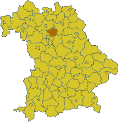
Forchheim is a district in Bavaria, Germany. It is bounded by (from the north and clockwise) the districts of Bamberg, Bayreuth, Nürnberger Land and Erlangen-Höchstadt.

History

Until 1803 the region was divided between the clerical state of Bamberg and the margravate of Brandenburg-Kulmbach centred in Bayreuth. Then it fell to Bavaria. The district in its present borders was established in 1972 by merging the former district of Forchheim with parts of the dissolved districts of Ebermannstadt and Pegnitz. The city of Forchheim lost its status as a district-free city and became the capital.

Geography

The main river is the Regnitz, which runs from south to north through the western parts of the district. East of the river the land rises to the hills of the Frankish Alb.

Coat of arms

Towns and municipalities

External links

* [http://www.landkreis-forchheim.de Official website] (German)


Wikimedia Foundation. 2010.

Игры ⚽ Поможем написать курсовую

Look at other dictionaries:

  • Forchheim am Kaiserstuhl — Forchheim am Kaiserstuhl …   Wikipédia en Français

  • Forchheim (disambiguation) — Forchheim may refer to the following places in Germany:*Forchheim, capital of the district of Forchheim, Bavaria *Forchheim am Kaiserstuhl, a municipality in Baden Württemberg *Forchheim (Beilngries), part of Beilngries, Bavaria *Forchheim… …   Wikipedia

  • District de Haute-Franconie — Regierungsbezirk Oberfranken Données générales Pays …   Wikipédia en Français

  • Forchheim — For other places called Forchheim, see Forchheim (disambiguation) Infobox German Location Name = Forchheim type = Stadt Wappen = Forchheim coat of arms.png lat deg = 49 |lat min = 43 |lat sec = 11 lon deg = 11 |lon min = 03 |lon sec = 29 Lageplan …   Wikipedia

  • Forchheim (arrondissement) — Arrondissement de Forchheim 49°43′11″N 11°03′29″E / 49.71972, 11.05806 …   Wikipédia en Français

  • Forchheim am Kaiserstuhl — Infobox Ort in Deutschland Name = Forchheim Wappen = Wappen Forchheim Kaiserstuhl.png lat deg = 48 |lat min = 09 |lat sec = 50 lon deg = 07 |lon min = 42 |lon sec = 09 Lageplan = Em forchheim.png Lageplanbeschreibung = Bundesland = Baden… …   Wikipedia

  • Haute-Franconie (district) — District de Haute Franconie District de Haute Franconie Regierungsbezirk Oberfranken Données générales Toponyme officiel ? …   Wikipédia en Français

  • Arrondissement de Forchheim — 49°43′11″N 11°03′29″E / 49.71972, 11.05806 …   Wikipédia en Français

  • Bezirksamt Forchheim — Wappen Deutschlandkarte …   Deutsch Wikipedia

  • Landkreis Forchheim — Wappen Deutschlandkarte …   Deutsch Wikipedia

Share the article and excerpts

Direct link
Do a right-click on the link above
and select “Copy Link”