- Dryden Regional Airport
-
Dryden Regional Airport 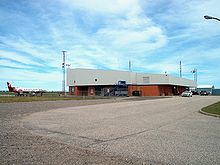
Dryden Regional Airport IATA: YHD – ICAO: CYHD
– WMO: 71527Summary Airport type Public Operator City of Dryden Location Dryden, Ontario Elevation AMSL 1,354 ft / 413 m Coordinates 49°49′54″N 092°44′39″W / 49.83167°N 92.74417°WCoordinates: 49°49′54″N 092°44′39″W / 49.83167°N 92.74417°W Website Map Location in Ontario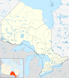
 CYHD
CYHDRunways Direction Length Surface ft m 06/24 2,000 610 Sand 12/30 6,000 1,829 Asphalt Statistics (2010) Aircraft movements 12,709 Source: Canada Flight Supplement[1]
Environment Canada[2]
Movements from Statistics Canada.[3]Dryden Regional Airport, (IATA: YHD, ICAO: CYHD), is located 4.3 NM (8.0 km; 4.9 mi) northeast of Dryden, Ontario, Canada.
Contents
Airlines and destinations
Airlines Destinations Bearskin Airlines Kenora, Red Lake, Sioux Lookout, Fort Frances, Thunder Bay, Winnipeg See also
References
- ^ Canada Flight Supplement. Effective 0901Z 20 October 2011 to 0901Z 15 December 2011
- ^ Synoptic/Metstat Station Information
- ^ Total aircraft movements by class of operation
External links
- Page about this airport on COPA's Places to Fly airport directory
- Past three hours METARs, SPECI and current TAFs for Dryden Regional Airport from NAV CANADA as available.
Airports in Canada By name A–B · C–D · E–G · H–K · L–M · N–Q · R–S · T–ZBy location indicator CA · CB · CC · CD · CE · CF · CG · CH · CI · CJ · CK · CL · CM · CN · CO · CP · CR · CS · CT · CV · CW · CY · CZBy province/territory National Airports System Calgary · Charlottetown · Edmonton · Fredericton · Gander · Halifax · Iqaluit · Kelowna · London · Moncton · Montréal-Mirabel · Montréal-Trudeau · Ottawa · Prince George · Québec · Regina · Saint John · St. John's · Saskatoon · Thunder Bay · Toronto · Vancouver · Victoria · Whitehorse · Winnipeg · YellowknifeRelated List of airports by ICAO code: C · List of defunct airports in Canada · List of heliports in Canada · List of international airports in Canada · National Airports System · Operation Yellow RibbonCategories:- Airports in Ontario
- Transportation in Kenora District, Ontario
- Dryden, Ontario
- Ontario airport stubs


Wikimedia Foundation. 2010.