- London Plan
-
For other uses, see London Plan (disambiguation).
 The geographical scope of the plan is the London region.
The London Plan is a planning document written by the Mayor of London, England in the United Kingdom and published by the Greater London Authority.[1] The plan was first published in final form on 10 February 2004 and has since been amended. The current version was published in February 2008.[2] The latest proposed amendments to the London Plan were published in April 2009[3] with consultation starting in October 2009 and the replacement plan expected to be published in 2011.[4]
Contents
Mandate
The plan replaced the previous strategic planning guidance for London issued by the Secretary of State and known as RPG3. It is a requirement of the Greater London Authority Act 1999 that the document is produced and that it deals only with matters that are of strategic importance to Greater London. The Act also requires that the London Plan includes in its scope:
- the health of Londoners,
- equality of opportunity,
- contribution to sustainable development in the United Kingdom.
Objectives
 Development must not encroach on green spaces.
The plan is a spatial development strategy for the Greater London area and has six objectives:
- To accommodate London’s growth within its boundaries without encroaching on open spaces
- To make London a better city for people to live in
- To make London a more prosperous city with strong and diverse economic growth
- To promote social inclusion and tackle deprivation and discrimination
- To improve London’s accessibility
- To make London a more attractive, well-designed and green city
Policies
Chapter Title Policy summary 1 Positioning London Analysis of forces underpinning London's past and future place in the world 2 The broad development strategy Strategic sustainable development policy 3 Thematic policies Population growth, economic growth, transport, development 4 Crosscutting policies Environment, quality of life, heritage, Blue Ribbon Network 5 The sub-regions Development of Sub-Regional Development Frameworks 6 Delivering the vision Delivery, performance indicators, monitoring Opportunity areas
The plan identifies dozens of areas of opportunity, which are where the bulk of efforts will be concentrated, with an aim at reducing social deprivation and creating sustainable development. The opportunity areas will be able to accommodate around 5,000 jobs each or about 2,500 homes, or a mixture of the two. The opportunity areas will mostly be town centres as opposed to suburban developments in the boroughs, although those are mentioned as important in terms of job growth and quality of life.
Sub regions
For the purposes of the plan, London is divided into five sub regions. The current regions were established in February 2008 as part of the Further Alterations to the London Plan. The sub regions radiate from the centre to combine inner and outer London boroughs.[5] These sub-regions, each with its own Sub Regional Implementation Framework, are:[6]
Sub region London boroughs Population Jobs Map 
North East Barking & Dagenham, City of London, Havering, Newham, Redbridge, Tower Hamlets, Waltham Forest 1.4 million 900,000 NE North Barnet, Camden, Enfield, Hackney, Haringey, Islington, Westminster 1.7 million 1.5 million N South East Bexley, Bromley, Greenwich, Lewisham, Southwark 1.3 million 500,000 SE South West Croydon, Kingston, Lambeth, Merton, Richmond, Sutton, Wandsworth 1.6 million 730,000 SW West Brent, Ealing, Hammersmith & Fulham, Harrow, Hillingdon, Hounslow, Kensington & Chelsea 1.6 million 900,000 W From 2004 to 2008 the sub regions were initially the same as the Learning and Skills Council areas set up in 1999:[7] Within this scheme there was a separate Central sub region. The London part of the Thames Gateway zone was entirely contained within the East London sub region. The 2004 to 2008 sub regions, which each had Sub-Regional Development Frameworks,[8] were:
Sub region London boroughs[9] Population (2001) 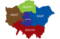
Central Camden, Kensington & Chelsea, Islington, Lambeth, Southwark, Wandsworth, Westminster. Although it is not part of the sub region Hammersmith and Fulham is often considered part of central London. 1,525,000 East Barking & Dagenham, Bexley, City of London, Greenwich, Lewisham, Hackney, Havering, Newham, Redbridge, Tower Hamlets 1,991,000 North Barnet, Enfield, Haringey, Waltham Forest 1,042,000 South Bromley, Croydon, Kingston, Merton, Richmond, Sutton 1,329,000 West Brent, Ealing, Hammersmith & Fulham, Harrow, Hillingdon, Hounslow 1,421,000 Separately defined is a Central Activities Zone which includes areas with a very high concentration of metropolitan activities.
Activity centres
All activity centres are categorised into two international centres, the West End and Knightsbridge; eleven metropolitan centres such as Bromley, Croydon, Sutton and Romford; 35 major centres such as Brixton, East Ham, Bexleyheath and Woolwich; and 156 district centres such as Hornchurch, Penge, Stoke Newington and Welling. Over 1,200 smaller neighbourhood and local centres are also identified in the plan.
Alterations
There have been a number of amendments to the London Plan which have been incorporated into the current version that was published in February 2008. Early alterations were made covering housing provision targets, waste and minerals. Further alterations to the plan covered climate change; London as a world city; The London Economy; Housing; Tackling social exclusion; Transport; London’s geography, the sub-regions and inter-regions; London’s suburbs; Liveability (including safety, security and open spaces); and the 2012 Olympic Games and Paralympic Games. The mayor gained new statutory powers following the Greater London Authority Act 2007. Following the change of mayor, a new review was initiated in July 2008.
Date Document February 2004 The London Plan October 2005 Draft Alterations to the London Plan: Housing Provision Targets Waste and Minerals December 2005 Reviewing the London Plan: Statement of Intent from the Mayor September 2006 Draft Further Alterations to the London Plan December 2006 Early Alterations to the London Plan on Housing provision targets, waste and minerals February 2008 The London Plan: Consolidated with Alterations since 2004 July 2008 Planning for a better London April 2009 A new plan for London: Proposals for the Mayor’s London Plan October 2009 The London Plan: Consultation draft replacement plan December 2009 Minor alteration to the consultation draft replacement London Plan See also
- Blue Ribbon Network - policy for London's waterways
References
- ^ Mayor of London (February 2008). "The London Plan (Consolidated with Alterations since 2004)". Greater London Authority. http://www.london.gov.uk/thelondonplan/docs/londonplan08.pdf.
- ^ Sarah Stevens and Ian Fergusson (2008). "The New Consolidated London Plan". Turley Associates. http://www.turleyassociates.co.uk/download.aspx?ID=210.
- ^ Mayor of London (April 2009). "A new plan for London: Proposals for the Mayor’s London Plan". Greater London Authority. http://www.london.gov.uk/archive/mayor/publications/2009/docs/london-plan-initial-proposals.pdf.
- ^ Mayor of London. "About the consultation: What happens next?". Greater London Authority. http://www.london.gov.uk/shaping-london/london-plan/what-next/. Retrieved 2009-10-12.
- ^ Mayor of London (February 2008). "The London Plan: Sub-regions, CAZ and government growth area policies". Greater London Authority. http://www.london.gov.uk/thelondonplan/caz/.
- ^ Mayor of London (September 2006). "Draft Further Alterations to the London Plan". Greater London Authority. http://www.london.gov.uk/archive/mayor/strategies/sds/further-alts/docs/alts-all.pdf.
- ^ Addison & Associates (June 2006). "Review of London's Sub Regional Boundaries". Greater London Authority. http://www.london.gov.uk/archive/mayor/planning/docs/review-srb.pdf.
- ^ Mayor of London (May 2006). "Sub Regional Development Frameworks". Greater London Authority. http://www.london.gov.uk/mayor/planning/srdf/index.jsp.
- ^ Mayor of London (February 2004). "The London Plan: Chapter 5". Greater London Authority. http://www.london.gov.uk/archive/mayor/strategies/sds/london_plan/lon_plan_5.pdf.
External links
- London Plan - GLA microsite
- Outer London Commission - established by Mayor "to advise how Outer London can play its full part in the city's economic success" (2009)
 Economy of the United Kingdom
World economy Companies Co-operatives · Employee-owned companies · FTSE 100 Index · FTSE 250 Index · FTSE Fledgling Index · FTSE SmallCap Index · Government-owned companiesCurrency, governance
and regulationBank of England (Governor of the Bank of England) · Budget · Company law · Competition Commission · Department for Business, Innovation and Skills · Financial Services Authority · Gilts · HM Revenue and Customs · HM Treasury (Chancellor of the Exchequer) · Monetary Policy Committee · Office for Budget Responsibility · Office of Fair Trading · Office of Gas and Electricity Markets · Pound sterling (Banknotes · Coinage) · Taxation · UK Debt Management Office · UK Financial Investments Limited · UK Statistics Authority · UK Trade & InvestmentFinancial services Baltic Exchange · Banking · Canary Wharf · The City · Euronext.liffe · Glasgow International Financial Services District · Insurance (Lloyd's of London) · LCH.Clearnet · London Interbank Offered Rate · London Metal Exchange · London Stock Exchange (Alternative Investment Market)History 1926 general strike · 2008 bank rescue package · 2009 bank rescue package · Agricultural Revolution · Big Bang · Black Wednesday · Corn Laws · Economic geography · Free trade · Gold standard · Great Depression · Industrial Revolution · Late-2000s recession · List of recessions · Long Depression · Marshall Plan · Nationalization · Navigation Acts · New Imperialism · Panic of 1796–1797 · Privatization · Second Industrial Revolution · Winter of DiscontentNations, regions and
citiesAtlantic Gateway · Birmingham (Big City Plan) · Bristol · Cornwall · Croydon (Croydon Vision 2020) · Devon · Expansion plans for Milton Keynes · Fishing · Leeds · List of counties by GVA · Liverpool · London (East London Tech City · London Plan) · M4 corridor · M11 Corridor · Manchester · Reading · Sheffield · Silicon Fen · Thames Gateway · Tourism · TransportAberdeen · Agriculture · Edinburgh · Fishing · Oil and gas · Renewable energy · Silicon Glen · Tourism · Transport · WhiskyPeople and labour Billionaires · Businesspeople · Demography · Income (Poverty) · Labour law (Equal opportunities · Minimum wage · Working Time Directive) · Pensions · Trade unions (Trades Union Congress) · Youth unemploymentSectors Agriculture · Construction · Education · Energy (North Sea oil · Renewable energy) · Forestry · Gambling · Healthcare · Internet · Manufacturing (Aerospace · Automotive · Pharmaceuticals) · Media (Cinema · Television) · Mining · Science and technology · Telecommunications · Tourism · Transport (Aviation)Trade and business
organisationsBusiness and employer associations · British Bankers' Association · British Chambers of Commerce · Confederation of British Industry · EEF the manufacturers organisation · Federation of Small Businesses · Industry trade groups · Institute of Directors · UKPA Category ·
  CommonsCategories:
- Local government in London
- United Kingdom planning policy
- London Plan
- Regional planning in London
- 2004 in London
- 2009 in London


Wikimedia Foundation. 2010.