- Gore, New Zealand
-
Gore
Maruawai (Māori)Location of Gore
 Gore
GoreCoordinates: 46°05′57″S 168°56′47″E / 46.09917°S 168.94639°E Country  New Zealand
Region Southland Territorial authority Gore District Government - Mayor Tracy Hicks - Deputy Mayor Cliff Bolger Area - Territorial 1,251.62 km2 (483.3 sq mi) Population (June 2010 estimate)[1] - Territorial 12,300 - Density 9.8/km2 (25.5/sq mi) - Urban 9,770 Time zone NZST (UTC+12) - Summer (DST) NZDT (UTC+13) Postcode(s) 9710 Area code(s) 03 Website www.GoreDC.govt.nz Gore is a town, surrounding borough, and district in the Southland region of the South Island of New Zealand.
Contents
Geography
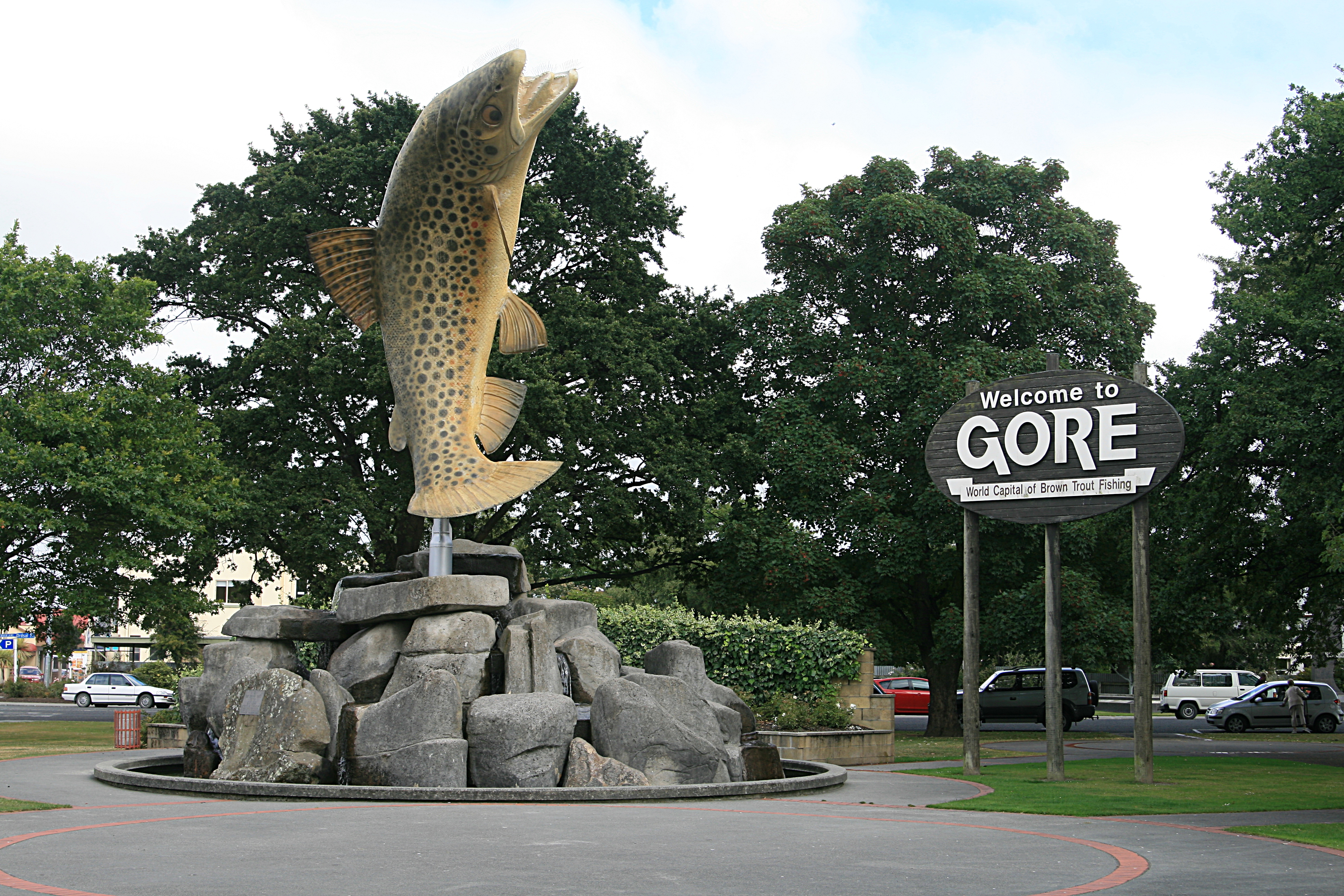
 Sculpture of Brown Trout at the northern entrance to Gore
The Gore District has a land area of 1,251.62 km² (483.25 sq mi) and a resident population of 12,300 (June 2010 estimate).[1]
The town of Gore is 64 kilometres northeast of Invercargill and 70 km west of Balclutha—Dunedin and Invercargill are the nearest cities. The urban area estimated resident population at the June 2010 estimate was 9,770, the second largest in Southland.[1] Gore is a service town for the surrounding farm communities.
It is divided by the Mataura River into Gore and East Gore, the majority of the town being situated on the western banks of the river. The Main South Line railway from Dunedin to Invercargill runs through the town, though passenger services ceased in 2003. Gore was once a busy railway junction; the Waimea Plains Railway ran west to connect with the Kingston Branch in Lumsden, while the Waikaka Branch connected with the Main South Line nearby in McNab. One of New Zealand's most famous preserved trains is the Kingston Flyer, which takes its name from a passenger express that once ran between Kingston and Gore.
Gore is known in New Zealand folklore as the home of Hokonui moonshine. During the days of prohibition, the Hokonui Hills to the west of the town gained a reputation for the production of illicit alcohol.
Gore's local radio station Hokonui Gold broadcasts from within the town.
History
Before the arrival of Europeans the current site of Gore was a part of or near the routes used by Maori travellers. Tuturau, near modern Mataura, was the nearest Maori settlement. In 1836 southern Maori repelled a raid from the north, which provided sufficient security for Europeans to purchase land and settle in the area. By the mid 1850s large tracts nearby had been converted into sheep runs.
As crossing the Mataura River involved a long fording, the locality became known as “the Long Ford”, or Longford. In 1862 a few town sections were surveyed on the west bank of the river and Longford was named Gore as a compliment to Sir Thomas Gore Browne, an early Governor of New Zealand. One of the first buildings was Long Ford House an accommodation house opened by local sawmill owner Daniel Morton[2]
A village named Gordon after Governor Sir Arthur Gordon became established on the opposite bank of the Mataura. By 1864 a road from Balclutha through Gore to Invercargill had been opened for wheeled traffic which allowed the establishment of a regular coach service between Invercargill and Dunedin.
Becomes established
By 1877 there were enough business opportunities in the area for the Bank of New Zealand to establish a branch in Gore. Within another three years both the Bank of Australasia and the Colonial Bank had also opened branches. In 1899 the Bank of New South Wales followed suit.[3]
After its construction began in the early 1870s, a railway line between Invercargill and Gore was opened on 30 August 1875. By 22 January 1879 the railway had been extended to Balclutha where it linked with an existing line to Dunedin. A private Waimea Plains railway from Gore to Lumsden was opened on 31 July 1880. This was subsequently purchased by the Government in 1886. It connected Gore with the Invercargill-Kingston branch line. By 1908 another branch had been completed via McNab to Waikaka. The extension of the railways established Gore as an important hub and had a significant effect on its development.[4]
By 1879, the “Ensign” newspaper was being published in the town, followed in 1887 by the rival “Standard”.
Becomes a borough
In 1885 Gore was constituted a borough and in 1890 Gordon, by now commonly known as East Gore, amalgamated with Gore.[5] It acquired a nickname of "Chicago of the South".[6][7]
By 1905 the population had increased to 2,354, compared with 1,618 in 1891. [8]
The establishment of the Gore Electric Light & Power Syndicate led in 1894 to Gore becoming the third town in New Zealand to install a generator and provide a public electricity supply.[9]
From the end of the Second World War until 1976 Gore enjoyed prosperity driven by record prices for agricultural produce which saw the town’s population rise from 5,000 in 1945 to 9,000 in 1976. By the late 1960s it was reputed to have the highest per-capita retail turnover of any New Zealand town.[10]
Decline
The farm sector went into decline after 1976 which lead to a corresponding decline in the population. Related businesses also closed, including the town’s iconic cereal mill, which had processed oats and other grains since 1877. Since 2000 prosperity has returned as large numbers of farms in the surrounding area were converted to dairy farms to take advantage of high prices for dairy produce. This growth lead to low employment in the town.
Jeremy Wells and Mikey Havoc falsely labelled Gore the gay capital of New Zealand in 1999, during Havoc and Newsboy's Sell-out Tour. Returning to the town to cover the 2008 election, Wells was confronted by a group of fifteen men angry over the comments. The group started harassing him at a petrol station, and followed him back to his hotel room, trapping him for ninety minutes before the police were called.[11]
Education in Gore
Gore and surrounding districts have various Primary, Intermediate & High Schools. The two secondary schools in Gore are:
- Gore High School (the largest school in Gore)
- St Peter's College, Gore a catholic school
The only intermediate school in Gore is
- Longford Intermediate
There are four primary schools in Gore:
- West Gore School (the biggest primary school)
- Gore Main School
- East Gore School
- St Marys School.
There are also another 6 primary schools in the Gore District
- Knapdale School
- Mataura School
- Otama School
- Pukerau School
- Waikaka School
- Willowbank School
Landmarks and notable features
 Fleming's Rolled Oats factory, a major landmark in central Gore.
Gore is well known for its connection with Country and Western music, with the annual New Zealand country music awards having been held in the town for 36 years.[12] It has a sister city relationship with Tamworth, New South Wales, the "Country Music Capital of Australia".
Recently Gore has also gained a reputation as a centre for the visual arts in the southern South Island. A major bequest to the town's Eastern Southland Art Gallery by Dr. John Money has left the institution with one of the country's best collections of ethnological art. This is partnered by an impressive collection of modern New Zealand work, including several notable pieces by Ralph Hotere.[13]
The Flemings "Creamoata Mill" is an iconic local building, with Flemings "Creamoata" brand of porridge once considered the National Breakfast,[14] and the mill itself considered one of the most modern cereal mills in the southern hemishphere. Production of all products was moved to Australia in 2001, and Creamoata was discontinued in 2008 after declining sales.[15] Goodman Fielder claimed that the plant was no longer viable as it was operating at less than one third of its capacity. The building's famous "Sgt Dan" remains because rights to it have been purchased by the buildings current owner "Sgt Dan Stockfoods Ltd".[15] The building has a Category I listing with the New Zealand Historic Places Trust.[16]
The former East Gore Presbyterian Church is one of the two remaining wooden Gothic churches designed by the eminent architect R.A. Lawson.[17] Built in 1881 and registered by the New Zealand Historic Places Trust,[citation needed] the main building is currently used as a performance and lecture theatre and the hall, built later, as a studio and flat for visiting artists. The latter houses the bedroom furniture from the Royal Suite commissioned for the Queen's Royal Tour to Southland in 1954.[18]
Notable residents
- Jimmy Cowan, international rugby player
- James Hargest, politician and military leader
- Luke Hurley, musician
- Hadyn Jones, television journalist[19]
- Shona McFarlane, artist and broadcaster
- Brian McKechnie international cricket and rugby player
- Justin Marshall, international rugby player
- Geoff Rabone, international cricketer
- Eric Roy, politician
- Jenny Shipley, former Prime Minister of New Zealand
- Barry Soper, political journalist
- Stu Wilson, international rugby player
- Mike Puru, radio host
See also
References
- ^ a b c "Subnational population estimates at 30 June 2010 (boundaries at 1 November 2010)". Statistics New Zealand. 26 October 2010. http://www.stats.govt.nz/~/media/Statistics/Methods%20and%20Services/Tables/Subnational%20population%20estimates/subpopest2001-10.ashx. Retrieved 7 March 2011.
- ^ http://www.teara.govt.nz/Places/Southland/SouthlandPlaces/4/en “Te Ara Encyclopedia of New Zealand“. Retrieved 16/03/09
- ^ http://www.nzetc.org/tm/scholarly/Cyc04Cycl-fig-Cyc04Cycl0771a.html “The Cyclopedia of New Zealand [Otago & Southland Provincial Districts] - Gore“. Retrieved 16/03/09
- ^ http://www.nzetc.org/tm/scholarly/Cyc04Cycl-fig-Cyc04Cycl0771a.html “The Cyclopedia of New Zealand [Otago & Southland Provincial Districts] - Gore“. Retrieved 16/03/09
- ^ http://www.teara.govt.nz/1966/G/Gore/Gore/en “Encyclopaedia of New Zealand 1966“. Retrieved 15/03/09
- ^ "A Trip to the Goldfields of Otago - Part VII". The Southland Times: p. 3. 29 May 1890. http://paperspast.natlib.govt.nz/cgi-bin/paperspast?a=d&d=ST18900529.2.23&l=en.
- ^ "Untitled". The Mataura Ensign: p. 2. 3 May 1892. http://paperspast.natlib.govt.nz/cgi-bin/paperspast?a=d&d=ME18920503.2.7&l=en.
- ^ http://www.nzetc.org/tm/scholarly/tei-Cyc04Cycl-t1-body1-d6-d1.html . “The Cyclopedia of New Zealand [Otago & Southland Provincial Districts] - Southland“. Retrieved 16/03/09.
- ^ Reilly, Helen: “Connecting the Country – New Zealand’s national grid 1886-2007”. Page 65. Steele Roberts, Wellington. ISBN 978-1-877448-40-9.
- ^ http://www.teara.govt.nz/1966/G/Gore/Gore/en Encyclopaedia of New Zealand 1966.
- ^ Lewis, Rebecca (16 November 2008). "Southern discomfort for Wells". New Zealand Herald. http://www.nzherald.co.nz/nz/news/article.cfm?c_id=1&objectid=10543283. Retrieved 2008-11-16.
- ^ "...Every year for the last 36 years Gore has hosted the New Zealand Gold Guitar Awards..."
- ^ Gallery webpage at www.gorenz.com
- ^ "Nostalgia". New Zealand Post. http://stamps.nzpost.co.nz/Cultures/en-NZ/Stamps/StampsHistoricalIssues/1999/Nostalgia.htm. Retrieved 22 January 2010.
- ^ a b McNeilly, Hamish (6 October 2008). "No Creamoata, but Dan soldiers on". The Otago Daily Times. http://www.odt.co.nz/your-town/gore/25833/no-creamoata-dan-soldiers. Retrieved 2010-01-22.
- ^ "Fleming's Creamoata Mill complex". Register of Historic Places. New Zealand Historic Places Trust. http://www.historic.org.nz/TheRegister/RegisterSearch/RegisterResults.aspx?RID=7470&m=advanced. Retrieved 2010-01-25.
- ^ J.F. McArthur (1981). From the Kirk on the Hill. Gore Publishing Company.
- ^ "Visiting Artist Programme with New Zealand". Hazelhurst Regional Gallery & Arts Centre, Sutherland Shire Council. Autumn 2004. http://www.suthentcent.com.au/ssc/rwpattach.nsf/viewasattachmentPersonal/NATALIE+VLIES~SSC~Hazelhurst+News+Spring+04.pdf/$file/Hazelhurst+News+Spring+04.pdf.
- ^ "TV's Hadyn Jones". Sunday Star Times. 1 January 2009. http://www.stuff.co.nz/sunday-star-times/entertainment/more-entertainment-stories/135359/TVs-Hadyn-Jones. Retrieved 30 April 2010.
External links
- Gore District Council
- The Golden Guitar Awards site
- http://www.library.otago.ac.nz/pdf/hoc_fr_bulletins/38_bulletin.pdf Hocken Collection Bulletin 38 - New Zealand’s ‘Little Lichfield’ - The literature of Eastern Southland.
Arthurton · Charlton · Chatton · Gore · Mandeville · Mataura · McNab · Pukerau · Waikaka · Willowbank
Coordinates: 46°05′57″S 168°56′47″E / 46.09917°S 168.94639°E
Categories:- Gore District, New Zealand
- Populated places in New Zealand


Wikimedia Foundation. 2010.