- Kingston-Port Ewen Suspension Bridge
Infobox_Bridge
bridge_name=Kingston-Port Ewen Suspension Bridge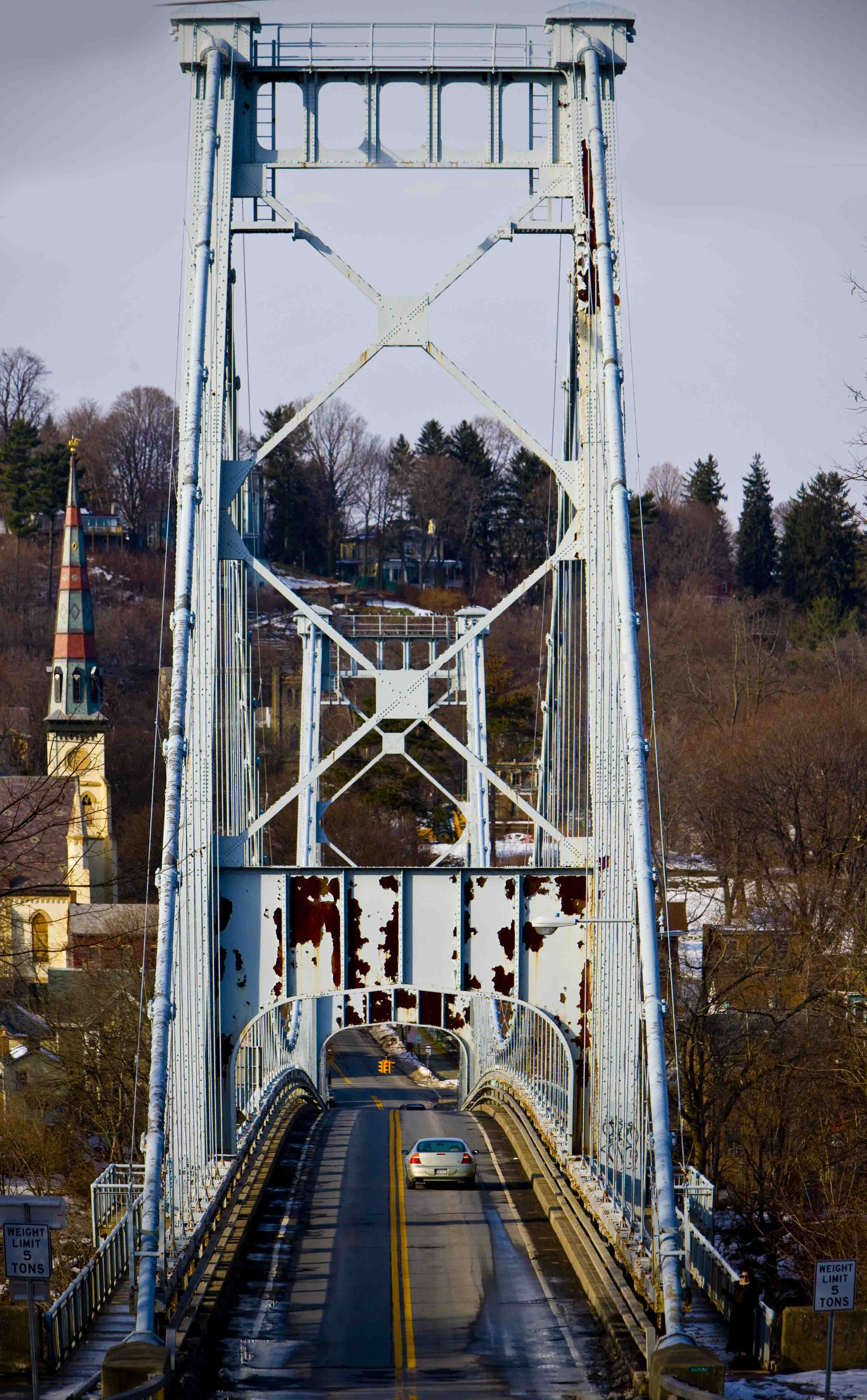
caption=Bridge looking north into Kingston, 2007.
official_name=Kingston-Port Ewen Suspension Bridge
carries=Wurts St. (Old 9W)
crosses=Rondout Creek
locale=Kingston, New York
maint=New York State Department of Transportation
id=1007350
design=Wire cableSuspension bridge
mainspan=705 feet (215 m)
length=2 side spans of 176.25 feet (54 m) each, anchorages, total length 1,145 ft (349 m)
width=2 lanes plus walkway, 37 feet (11 m)
clearance=
below=85 ft (26 m)
traffic=15,700
open=1921
closed=still open but reportedly limited to 5 tons (4.5 tonnes)
toll=no
map_cue=
map_
map_text=TIGER image, Red dot marks bridge
map_width=250px
lat=41.91716
long=-73.984165The Kingston-Port Ewen Suspension Bridge, sometimes known as the "Rondout Creek bridge", "Old Bridge" or "Wurts Street Bridge", is a steel
suspension bridge spanningRondout Creek , near where it empties into theHudson River . It connects the City of Kingston to the north, with the village of Port Ewen to the south. Completed in 1921, it was the final link in New York's first north-south highway on the West Shore of the Hudson, and is considered an important engineering accomplishment associated with the development of earlymotoring .Construction began in 1916, with a view to replacing the Rondout Creek ferry "Skillypot" [The Skillypot was a
chain ferry , named after a derivative of a Dutch (upstate New York had a heavy Dutch influence) word for tortoise. (" [http://www.cr.nps.gov/nr/travel/kingston/k22.htm National Park Service] " site)] , known for sporadic service. The bridge was designed by the firms ofHolton D. Robinson andJohn A. Roebling's Sons Company [information from theStructurae [http://en.structurae.de/structures/data/index.cfm?ID=s0007345 page] ] , with Holton D. Robinson, Daniel E. Moran, William Yates listed as chief engineers [Information from theBridgemeister.com [http://www.bridgemeister.com/bridge.php?bid=138 site] ] Construction was hampered by local political and financial difficulties, as well as material shortages caused by entry by the United States intoWorld War I , and was suspended until 1920.When construction resumed,
David B. Steinman was among the engineering staff, acting as Assistant Engineer. Completion took about a year, and local legend has it that the contractors employed a woman as a welder: commonplace during World War II, but unheard of in 1920. Ten thousand people attended the bridge's dedication on November 2, 1921. The bridge has a very hilly approach on the north side and crosses a small island in the creek. It forms a dramatic backdrop to theRondout-West Strand Historic District to the east.Although the bridge was a key
US Route 9W link when it opened, carrying 9W and Wurts Street, in1978 9W was rerouted to theJohn T. Loughran Bridge . 9W at that point is also called Frank Koenig boulevard. The weight limit on the bridge now appears to be only 5 tons [Top picture on [http://www.bridgemeister.com/pic.php?pid=33 this] Bridgemeister.com page shows a 5 ton limit sign] .Current condition
According to the U.S. Department of Transportation (“DOT”), one of every eight bridges in the nation is structurally deficient; among the most deficient is the Kingston-Port Ewen Suspension Bridge. The bridge rates consistently low in state and federal dot evaluations. It is rated as a 2 out of 100 from the federal DOT and a 3.875 out of 7 from the state. Both evaluations take away points for obsolete design, which is not really a concern since looking charmingly obsolete may be its only real function since a newer, larger bridge with wider, straighter approaches was installed less than 1/4 mile from This one. The new bridge is less ornate though perhaps more functional, but has the effect of splitting the downtown area and was made possible only by the demolition of half of the downtown
Rondout, New York historic district. The old bridge is considered structurally deficient by both agencies and for that reason it is limited to carrying vehicles of 5 tons or less. According to a structures engineer for the state DOT, an inspection of the main cables will be carried out in the spring of 2008 by the engineering firm of Modjeski & Masters which specializes in signature (unusual) & suspension bridges. A complete renovation is planned for 2009 but replacing the main cables is well is beyond the scope of that plan. In 2004 theFederal Highway Administration estimated the reconstruction cost at 3 million dollars. The original cost of the bridge was called $700,000 in 1921 which is like eight million dollars in 2007 according to theBureau of Labor Statistics .In April 2008 the main cables were inspected by the Department of Transportation of the State of New York and found to be in good condition. Test borings were made several yards from the existing anchorages on both sides to determine the feasibility of re-locating the anchor points.
References
External links
* [http://www.cr.nps.gov/nr/travel/kingston/k22.htm description] from National Park Service site
* [http://www.cr.nps.gov/nr/travel/kingston/buildings/bridge2.jpgca. 1922 image] from National Park Service site
* [http://www.bridgemeister.com/bridge.php?bid=138 listing] atBridgemeister.com
* [http://www.bridgemeister.com/pic.php?pid=33 picture gallery] atBridgemeister.com
* [http://www.bridgemeister.com/pic.php?pid=1214 another picture gallery] atBridgemeister.com
*
* [http://www.inventionfactory.com/history/RHAbridg/ Roebling's Bridge Division] main site
* [http://www.klyneesopusmuseum.org/area.html Area timeline] putting bridge opening in context
* [http://www.nynjctbotany.org/whudson/esopustown.html Another area timeline] references earlier bridge.
* [http://tiger.census.gov/cgi-bin/mapsurfer?infact=2&outfact=2&act=move&off=CITIES&on=streets&tlevel=-&tvar=-&tmeth=i&mlat=0&mlon=-73.9847183&msym=smalldot&mlabel=Kingston_Port_Ewen_Bridge&murl=&lat=41.91526&lon=-73.98463&wid=0.011&ht=0.011&conf=mapnew.con Map] fromTIGER map image generation service
Wikimedia Foundation. 2010.