- Chesil Beach
-
Coordinates: 50°36′14″N 2°30′58″W / 50.604°N 2.516°W
Chesil Beach
Chesil Bank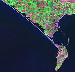
Satellite view of Chesil Beach (linear feature in blue running diagonally NW-SE) from Abbotsbury to the Isle of Portland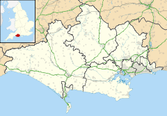
 Chesil Beach
Chesil Bank
 Chesil Beach
Chesil Bank shown within DorsetOS grid reference SY635784 List of places: UK • England • Dorset  Chesil Beach viewed from the Isle of Portland
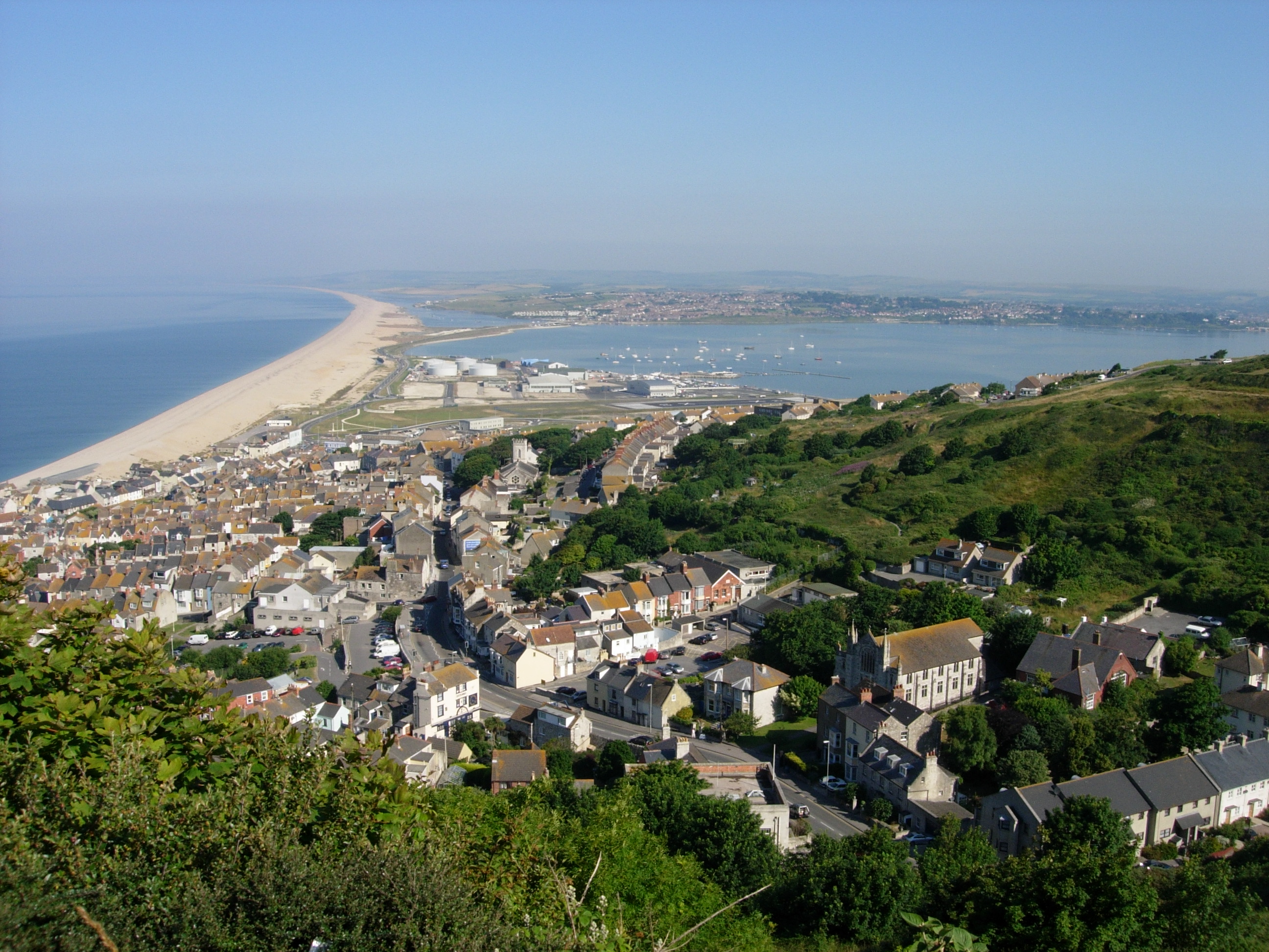
 Chesil Cove at the Portland end of Chesil Beach
Chesil Beach, sometimes called Chesil Bank, in Dorset, southern England is one of three major shingle structures in Britain.[1] Its toponym is derived from the Old English ceosel or cisel, meaning "gravel" or "shingle".
The beach is often identified as a tombolo, although research into the geomorphology of the area has revealed that it is in fact a barrier beach which has "rolled" landwards, joining the mainland with Portland Bill, giving the appearance of a tombolo.[2] The shingle beach is 29 kilometres (18 mi) long, 200 metres (660 ft) wide and 15 metres (50 ft) high. The beach and the Fleet are part of the Jurassic Coast, a UNESCO World Heritage Site, and the location for a book, On Chesil Beach by Ian McEwan.
At the eastern end of the beach at the village of Chiswell, against the cliffs of the Isle of Portland, the beach curves round sharply to form Chesil Cove. This part of the beach protects the low-lying village from flooding. Westwards the shingle forms a straight line along the coast, enclosing the Fleet, a shallow[3] tidal lagoon.
The beach provides shelter from the prevailing winds and waves for the town of Weymouth and the village of Chiswell, which would otherwise probably not exist
Varying with the Bank's unbroken increase in height, to 14.7 metres (48 ft), above mean high water, the size of the flint and chert shingle varies from pea-sized at the north-west end (by West Bay) to orange-sized at the south-east end (by Portland). It is said that smugglers who landed on the beach in the middle of the night could judge "exactly where they were" by the size of the shingle.[4]
Contents
The Fleet Lagoon
From West Bay to Cliff End the beach is piled up against the cliff. At Cliff End a hollow forms behind the beach and at Abbotsbury a stretch of saline (or brackish) water called the Fleet Lagoon begins. The Fleet is home to many wading birds and Abbotsbury Swannery, and fossils can be found in the sand and mud.
Both Chesil Beach and the Fleet Lagoon are a Site of Special Scientific Interest, and the view of the beach from Abbotsbury has been voted by Country Life magazine as Britain's third best view. The Fleet Lagoon and Chesil Beach feature in the novel Moonfleet by J. Meade Falkner (1898), in which the village of Moonfleet is based on the real village of East Fleet.
Origin
The origin of Chesil Beach has been argued over for some time.[5] Originally it was believed that beach material was from the Budleigh Salterton pebble beds to the west and later from Portland to the south east. The differences between the pebbles on the beach and nearby sources is now put down to the Flandrian isostatic sea level rise, so the feature could also be considered a barrier beach or bar, that happens to connect the mainland to an island rather than a 'true' tombolo. Normally, tombolos are created due to the effects of the island on waves (through refraction) and to sediment transport, which usually produces a beach perpendicular to the mainland rather than parallel to it.
World War Two defences
Because of the low population density of nearby areas and their proximity to the naval base on Portland, the beach and the Fleet were used for machine gun training and bouncing bomb testing for Operation Chastise in World War II.
The World War Two defences constructed on and around Chesil Beach have been documented. A double row of anti-tank blocks divides the beach near Abbotsbury. The portion of the beach to the east of this division, in front of Fleet Lagoon, had no passive defences against a landing, whereas the beach to the west was protected with miles of Admiralty scaffolding with anti-tank ditches and minefields and flame fougasse installations a little further inland. There were many pillboxes.[6]
See also
The Jurassic Coast stretches over a distance of 153 kilometres (95 mi), from Orcombe Point near Exmouth, in the west, to Old Harry Rocks on the Isle of Purbeck, in the east.[7] The coastal exposures along the coastline provide a continuous sequence of Triassic, Jurassic and Cretaceous rock formations spanning approximately 185 million years of the Earths history. The localities along the Jurassic Coast includes a large range of important fossil zones.
- List of places on the Jurassic Coast
- List of Dorset beaches
- Jurassic Coast
Gallery
 Chesil Beach, the Fleet and the Isle of Portland, from the north-west over Abbotsbury
-

Portland Bill and Chesil Beach from the air
-

Looking west down Chesil Beach by Abbotsbury
-

Shingle on Chesil Beach at Chesil Cove
-

Shoes show size of shingle near Portland entrance to beach (chert and flint)
-

Double row of anti-tank blocks near Abbotsbury.
References
- Notes
- ^ A. P. Carr and M. W. L. Blackley, "Investigations Bearing on the Age and Development of Chesil Beach, Dorset, and the Associated Area" Transactions of the Institute of British Geographers, No. 58 (March 1973) pp. 99-111.
- ^ http://www.jurassiccoast.com/380/the-coast-uncovered-30/geo-highlights-226/chesil-beach-finest-barrier-beach-in-europe-616.html
- ^ The lagoon is 3m at its deepest (Carr and Blackley 1973:99.
- ^ Portland history
- ^ The extensive literature was reviewed by W.J. Arkell, "the geology of the country around WeymouthSwanage, Corfe and Lulworth," Memoirs of the Geological Survey of Great Britain, 1947, and again, briefly, by Carr and Blackley, 1977.
- ^ Foot 2006, pp. 56-63.
- ^ "Dorset and East Devon Coast". UNESCO World Heritage Centre. 2001. http://whc.unesco.org/pg.cfm?cid=31&id_site=1029. Retrieved 2007-01-14.
- Bibliography
- Foot, William (2006). Beaches, fields, streets, and hills ... the anti-invasion landscapes of England, 1940. Council for British Archaeology. ISBN 1-902771-53-2.
External links
 Media related to Chesil Beach at Wikimedia Commons
- Website for Chesil Beach and a number of associated organisations
- Southampton University - Information and Photos
- Denver University - Overview
- Fleet Study Group
- Chesil Beach & The Fleet Special Protection Area
- The Fleet Observer - A Local Charity site providing information on the area
Ceremonial county of Dorset Unitary authorities - Bournemouth
- Poole
Boroughs or districts Major settlements Rivers Topics - Beaches
- County Council
- Flag
- Geology
- History
- Lord Lieutenants
- Museums
- People
- Places
- Settlements
- SSSIs
- Transport
Categories:- Beaches of Dorset
- Geography of Dorset
- Geography of Weymouth, Dorset
- Isle of Portland
- Jurassic Coast
- Lagoons
- Spits of England
- Nature Conservation Review sites
- Sites of Special Scientific Interest in Dorset
- Special Protection Areas in England


Wikimedia Foundation. 2010.