- Fort Apache Indian Reservation
-
White Mountain Apache Tribe of the Fort Apache Reservation 
Total population 12,429 Regions with significant populations  United States Arizona)
Languages Apache, English
Religion Christianity, Native American Church, traditional tribal religion
Related ethnic groups Western Apache, San Carlos Apache
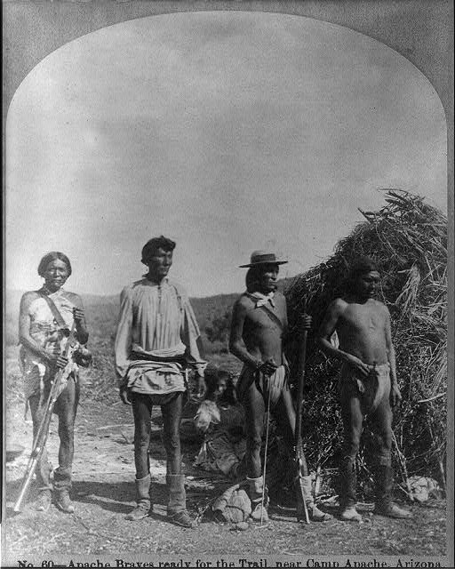
 Apache warriors near the fort, 1873
 White Mountain Apache, photographed prior to 1903 by Edward S. Curtis.
The Fort Apache Indian Reservation is an Indian reservation in Arizona, United States, encompassing parts of Navajo, Gila, and Apache counties. It is home to the federally recognized White Mountain Apache Tribe of the Fort Apache Reservation, a Western Apache tribe. It has a land area of 2,627.608 sq mi (6,805.474 km²) and a population of 12,429 people as of the 2000 census.[1] The largest community is Whiteriver.
Contents
Geography
The Fort Apache Indian Reservation is covered mostly by pine forests and is habitat to a variety of forest wildlife. It is located directly south of the Mogollon Rim. The highest point in the reservation is Baldy Peak, with an elevation of 11,403 ft (3,476 m).
Economy
 The Fort Apache Indian Reservation, south of Pinetop-Lakeside, Arizona.
The tribe operates the Sunrise ski resort and the Hon Dah Resort Casino. It has built the Apache Cultural Center & Museum, constructed in the traditional style of a gowa.
Other attractions within the reservation include the Fort Apache Historic Park, which has 27 buildings from the historic fort and a 288-acre National Historic District; and other historic sites. Kinishba Ruins, an ancient archeological site (AD1150-1350) of the western Pueblo culture, is a National Historic Landmark and is located on nearby associated tribal trust lands. Appointments may be made to visit the site.
Demographics
The demographics of the White Mountain Apache are similar to those of the people at the San Carlos Apache Indian Reservation, which is directly to the south. As at San Carlos, the median household income is around $14,000, and more than half the population lives under the poverty line.[1]
See also
- Apache
- Sunrise Park Resort
- Battle of Cibecue Creek
- Battle of Fort Apache
References
- ^ a b Fort Apache Reservation, Arizona, United States Census Bureau
Communities
- Canyon Day
- Cibecue
- East Fork
- McNary
- Whiteriver
- Carrizo
References
- Fort Apache Reservation, Arizona United States Census Bureau
External links
- White Mountain Apache Tribe - Official website
- "Fort Apache Historic Park and Kinishba Ruins", Nohwike’ Bágowa (House of Our Footprints), White Mountain Apache Culture Center & Museum
- Fort Apache Heritage Foundation
Coordinates: 33°55′43″N 110°07′55″W / 33.92861°N 110.13194°W
Categories:- American Indian reservations in Arizona
- Geography of Apache County, Arizona
- Geography of Gila County, Arizona
- Geography of Navajo County, Arizona
- Federally recognized tribes in the United States
- National Historic Districts in Arizona
- Apache tribes
- Mogollon Rim


Wikimedia Foundation. 2010.