- Counties of Estonia
-
Estonia 
This article is part of the series:
Politics and government of
Estonia- Elections: 2011 - 2007
- Political parties
- Politicians
- Counties (Maakond)
- Municipalities
- EU Politics
- Foreign relations
- Human rights
A county (Estonian: maakond) is an administrative subdivision of Estonia. Estonia is divided into 15 counties. The government (Estonian: maavalitsus) of each county is led by a county governor (Estonian: maavanem), who represents the national government at the regional level. Governors are appointed by the government for a term of five years.
Each county is further divided into municipalities which are of two types: urban municipality, or town (linn), and rural municipality, or parish (vald).
Contents
List of counties
Population figures represent 1 January 2009.[1]
Counties Capital Area Population Harjumaa Tallinn 4,333 km² 524,938 Hiiumaa Kärdla 989 km² 10,097 Ida-Virumaa Jõhvi 3,364 km² 169,688 Jõgevamaa Jõgeva 2,604 km² 36,780 Järvamaa Paide 2,623 km² 36,130 Läänemaa Haapsalu 2,383 km² 27,477 Lääne-Virumaa Rakvere 3,627 km² 67,151 Põlvamaa Põlva 2,165 km² 31,002 Pärnumaa Pärnu 4,807 km² 88,466 Raplamaa Rapla 2,980 km² 36,678 Saaremaa Kuressaare 2,673 km² 34,723 Tartumaa Tartu 2,993 km² 149,605 Valgamaa Valga 2,044 km² 34,135 Viljandimaa Viljandi 3,422 km² 55,657 Võrumaa Võru 2,305 km² 37,888 History
Main article: History of Estonia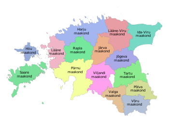

50 km  Map of south Baltic region circa 1705.
In the first centuries AD political and administrative subdivisions began to emerge in Estonia. Two larger subdivisions appeared: the parish (kihelkond) and the county (maakond). The parish consisted of several villages. Nearly all parishes had at least one fortress. The defense of the local area was directed by the highest official, the parish elder. The county was composed of several parishes, also headed by an elder. By the 13th century the following major counties had developed in Estonia: Saaremaa (Osilia), Läänemaa (Rotalia or Maritima), Harjumaa (Harria), Rävala (Revalia), Virumaa (Vironia), Järvamaa (Jervia), Sakala (Saccala), and Ugandi (Ugaunia).[2] Additionally there were several smaller elderships in central Estonia where danger of war was smaller – Vaiga, Mõhu, Nurmekund and Alempois. The exact number and borders of some elderships are disputed.
The first documented mentioning of Estonian political and administrative subdivisions comes from the Chronicle of Henry of Livonia, written in the 13th Century during the Northern Crusades.
The Autonomy of the Estonia counties and parishes ended after conquered and divided between Denmark, Livonian Order, Bishopric of Dorpat and Bishopric of Ösel-Wiek. The name of Rävala became Reval, replacing the name of an Estonian town Lindanisse, later Tallinn. Ugandi, Sakala and the smaller elderships disappeared from common usage.
In the 1580s, after the Livonian war as Sweden had conquered Northern Estonia, Harju, Järva, Lääne and Viru counties were officially formed there. Southern Estonia, which belonged to Poland 1582-1625, was divided into voivodships of Pärnu and Tartu; the island of Saaremaa belonged to Denmark until 1645. They all became counties as they went under Swedish rule.
This administrative system mostly remained as Estonia went under Russian rule as a result of the Northern War. In 1793 were formed Võru County in the south of Tartumaa, Viljandi County between Tartu and Pärnu counties, and Paldiski County in the west of Harjumaa. In 1796 Paldiski County was joined with Harjumaa again. Until 1888 Võrumaa and Viljandimaa were not completely independent from Tartumaa and Pärnumaa respectively.
Several changes were made to the borders of countis after Estonia became independent, most notably the formation of Valga County (from parts of Võru, Tartu and Viljandi counties) and Petseri County (area acquired from Russia with the 1920 Tartu peace treaty).
During the Soviet rule, Petseri County once again became a part of Russia in 1945. Hiiumaa seceded from Läänemaa in 1946, Jõgevamaa from Tartumaa in 1949 and Jõhvimaa (modern Ida-Virumaa) from Virumaa in 1949. Counties were completely dissolved in 1950 as Estonian SSR was divided into regions (rajoonid) and (until 1953) oblasts. Until the 1960s the borders of regions changed often until 15 of them were left. Out of them, Põlva and Rapla regions became separate, while the others were roughly corresponding to the pre-1950 counties.
Counties were re-established in 1 January 1990 in the borders of the Soviet-era regions. Due to the numerous differences between the current and historical (pre-1940) layouts, the historical borders are still used in ethnology, representing cultural and linguistical differences better.
See also
- Ranked list of Estonian counties
- Flags of Estonian Counties
- Coats of arms of Estonian Counties
- ISO 3166-2:EE
- Municipalities of Estonia
References
- ^ "Population by sex, ethnic nationality and county, 1 January". stat.ee. Statistics Estonia. 1 January 2009. http://pub.stat.ee/px-web.2001/Dialog/varval.asp?ma=PO0222&path=../I_Databas/Population/01Population_indicators_and_composition/04Population_figure_and_composition/&lang=1. Retrieved 2009-10-18.
- ^ Estonia and the Estonians (Studies of Nationalities) Toivo U. Raun p.11 ISBN 0-8179-2852-9
External links
- Local Government Reform Estonian Institute publication
Counties of Estonia Harjumaa · Hiiumaa · Ida-Virumaa · Järvamaa · Jõgevamaa · Läänemaa · Lääne-Virumaa · Pärnumaa · Põlvamaa · Raplamaa · Saaremaa · Tartumaa · Valgamaa · Viljandimaa · Võrumaa

First-level administrative divisions in Europe Sovereign
statesAlbania · Andorra · Armenia2 · Austria · Azerbaijan3 · Belarus · Belgium · Bosnia and Herzegovina · Bulgaria · Croatia · Cyprus2 · Czech Republic · Denmark · Estonia · Finland · France1 · Georgia3 · Germany · Greece · Hungary · Iceland · Ireland · Italy · Kazakhstan2 · Latvia · Liechtenstein · Lithuania · Luxembourg · Republic of Macedonia · Malta · Moldova · Monaco · Montenegro · Netherlands · Norway · Poland · Portugal · Romania · Russia1 · San Marino · Serbia · Slovakia · Slovenia · Spain · Sweden · Switzerland · Turkey1 · Ukraine · United Kingdom
States with limited
recognitionAbkhazia3 · Kosovo · Northern Cyprus2 · South Ossetia3
1 Has part of its territory outside Europe. 2 Considered European for cultural, political and historical reasons but is geographically in West Asia. 3 Partially or entirely in Asia, depending on the definition of the border.Table of administrative country subdivisions by country Categories:- Counties of Estonia
- Subdivisions of Estonia
- Lists of country subdivisions
- Country subdivisions of Europe
- First-level administrative country subdivisions
- Estonia-related lists


Wikimedia Foundation. 2010.